
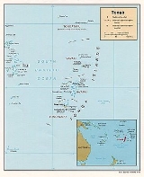
Geography of Tonga
Encyclopedia
Geology
Though administratively divided into the three main island groups of Tongatapu, Ha'apai, and Vava'u (excluding the outlying islands), the Tonga archipelago is actually made of two geologically different parallel chains of islands.The western islands, such as 'Ata, Fonuafo'ou, Tofua
Tofua
Tofua Caldera, in Tonga, is the summit caldera of a steep-sided composite cone that forms Tofua Island. Tofua Island is in Tonga's Ha'apai island group. Pre-caldera activity is recorded by a sequence of pyroclastic deposits and lavas constituting the older cone, followed on the northern part of the...
, Kao
Kao (island)
Kao is an island and stratovolcano in Tonga. It reaches above sea level, the highest point in Tonga. The date of its last eruption is unknown, and fresh lava flows are not seen, but the absence of deep erosional gullies or high sea cliffs suggests a very recent origin. It lies about north of...
, Lata'iki, Late
Late (Tonga)
Late Island is an uninhabited volcanic island southwest of Vavau in the kingdom of Tonga.The small, 6-km-wide circular island of Late, lying along the Tofua volcanic arc about 55 km WSW of the island of Vavau, contains a 400-m-wide, 150-m-deep summit crater with an ephemeral lake...
, Fonualei, Toku, Niuatoputapu
Niuatoputapu
For the 2009 tsunami, see the main article: 2009 Samoa tsunami.Niuatoputapu is an island in the island nation of Tonga, Pacific Ocean. Its name means sacred island. Older European names for the island are Traitors island or Keppel island.Niuatoputapu is located in the north of the country,...
, and Tafahi
Tafahi
Tafahi is a small island in the north of the Tonga archipelago, in fact closer to Savaii than the main islands of Tonga. It is only north-northeast away from Niuatoputapu, and fishermen communicate in small outboard motorboats almost daily between the two.Other names for Tafahi are Cocos Eylant ...
, make up the Tongan Volcanic Arch and are all of volcanic origin. They were created from the subduction
Subduction
In geology, subduction is the process that takes place at convergent boundaries by which one tectonic plate moves under another tectonic plate, sinking into the Earth's mantle, as the plates converge. These 3D regions of mantle downwellings are known as "Subduction Zones"...
of the western-moving Pacific plate
Pacific Plate
The Pacific Plate is an oceanic tectonic plate that lies beneath the Pacific Ocean. At 103 million square kilometres, it is the largest tectonic plate....
under the Australia-India plate at the Tonga Trench. The Tongan Islands sit on the Australia-India plate just west of the Tonga Trench
Tonga Trench
The Tonga Trench is located in the South Pacific Ocean and is deep at its deepest point, known as the Horizon Deep.The Tonga Trench is a convergent plate boundary. The trench lies at the northern end of the Kermadec-Tonga Subduction Zone, an active subduction zone where the Pacific Plate is being...
. These volcanoes are formed when materials in the descending Pacific plate heat and rise to the surface. There is only limited coral reef development on these islands, except for Niuatoputapu, which has inhibited human settlement.
The eastern islands are nonvolcanic and sit above the mostly submerged Tonga ridge that runs parallel to the Tongan Volcanic Arch and the Tongan Trench. Of these islands, only 'Eua
'Eua
Eua is a smaller but still major island in the kingdom of Tonga. It is close to Tongatapu, but forms a separate administrative division. It has an area of 87.44 km2, and a population in 2006 of 5,165 people.- Geography :...
has risen high enough to expose its underlying Eocene
Eocene
The Eocene Epoch, lasting from about 56 to 34 million years ago , is a major division of the geologic timescale and the second epoch of the Paleogene Period in the Cenozoic Era. The Eocene spans the time from the end of the Palaeocene Epoch to the beginning of the Oligocene Epoch. The start of the...
volcanic bedrock, the rest are either low coral limestone islands (Tongatapu
Tongatapu
Tongatapu is the main island of the Kingdom of Tonga and the location of its capital Nukualofa. It is located in Tonga's southern island group, to which it gives its name, and is the country's most populous island, with approximately 71,260 residents , 70.5% of the national population...
, Vava'u
Vava'u
Vavau is an island chain of one large island and 40 smaller ones in Tonga. According to tradition Maui fished both Tongatapu and Vavau but put a little more effort into the former. Vavau rises 204 meters above sea level...
, Lifuka
Lifuka
Lifuka is an island in the Kingdom of Tonga. It is located within the Haapai Group in the centre of the country, to northeast of the national capital of Nukualofa...
) or sand cay islands ('Uoleva
Uoleva
Uoleva is an sand-cay island in Lifuka district, in the Haªapai islands of Tonga. Almost uninhabited, it is known for its three small resorts and clean, quiet beaches. -The Resort Island:...
, [[ʻUiha|'Uiha]]). These islands are surrounded by "a protective and resource-rich labyrinth of fringing, apron and off-shore barrier reefs" that have supported most of the human settlement in Tonga ever since the first Lapita People arrived approximately circa 900 BCE.
The Tongan Volcanic Arc has been important in supplying the islands on the Tonga ridge with an andesite
Andesite
Andesite is an extrusive igneous, volcanic rock, of intermediate composition, with aphanitic to porphyritic texture. In a general sense, it is the intermediate type between basalt and dacite. The mineral assemblage is typically dominated by plagioclase plus pyroxene and/or hornblende. Magnetite,...
tephra
Tephra
200px|thumb|right|Tephra horizons in south-central [[Iceland]]. The thick and light coloured layer at center of the photo is [[rhyolitic]] tephra from [[Hekla]]....
soil that has resulted in "an extremely rich soil capable of supporting a high-yield, short-fallow agricultural system." Also, the andesite/basalt from the volcanoes were initially used as "hammerstones, weaving weights, cooking stones, and decorative pebbles for grave decoration." Tafahi island in the far north provided volcanic glass to initial human settlers.
Facts
Geographic coordinates: 20°S 175°WMap references:
Oceania
Area:
total:748 km² (289 sq mi)
land:718 km² (277 sq mi)
water:
30 km² (12 sq mi)
Land boundaries:
0 km (0 mi)
Coastline:
419 km (260.4 mi)
Maritime claims:
continental shelf:
200 m (656 ft) depth or to the depth of exploitation
exclusive economic zone:
200 nmi (370.4 km; 230.2 mi)
territorial sea:
12 nmi (22.2 km; 13.8 mi)
Climate:
tropical; modified by trade winds; warm season (December to May), cool season (May to December)
Terrain:
most islands have limestone base formed from uplifted coral formation; others have limestone overlying volcanic base
Elevation extremes:
lowest point:
Pacific Ocean 0 m (0 ft)
highest point:
unnamed location on Kao
Kao (island)
Kao is an island and stratovolcano in Tonga. It reaches above sea level, the highest point in Tonga. The date of its last eruption is unknown, and fresh lava flows are not seen, but the absence of deep erosional gullies or high sea cliffs suggests a very recent origin. It lies about north of...
1033 m (3,389 ft)
Natural resources:
fish, fertile soil
Land use:
arable land:
24%
permanent crops:
43%
permanent pastures:
6%
forests and woodland:
11%
other:
16% (1993 est.)
Irrigated land:
NA km²
Natural hazards:
cyclones (October to April); earthquakes and volcanic activity at Fonuafo'ou (Falcon Shoal/Island) and Late'iki (Metis Shoal
Metis Shoal
Metis Shoal is a shoal at the top of a submarine volcano, located between the islands of Kao and Late in Tonga. When the volcano erupted in 1995 a 43 metre high island formed, composed of a solid lava dome above the surface...
/Island)
Environment - current issues:
deforestation results as more and more land is being cleared for agriculture and settlement; some damage to coral reefs from starfish and indiscriminate coral and shell collectors; overhunting threatens native sea turtle populations
Environment - international agreements:
party to:
Biodiversity, Climate Change, Desertification, Law of the Sea, Marine Life Conservation, Nuclear Test Ban, Ozone Layer Protection, Ship Pollution
signed, but not ratified:
none of the selected agreements
Geography - note:
archipelago of 170 islands (36 inhabited)