
Geography of Jersey
Encyclopedia
This article describes the geography
of Jersey
, an island territory in the English Channel
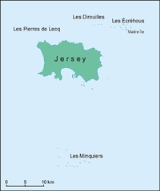
. The island of Jersey has an area of 116 square kilometres, with 70 kilometres of coastline. Jersey claims a territorial sea of 3 nmi (5.6 km; 3.5 mi) and an exclusive fishing zone of 12 nmi (22.2 km; 13.8 mi).
Jersey is the largest and southernmost of the Channel Islands
. It is located north of Brittany
and west of the Cotentin Peninsula
in Normandy
. About 30% of the population of the island is concentrated in Saint Helier
.
, Les Minquiers
, Les Pierres de Lecq
, Les Dirouilles
.
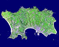
The lowest point in the island is the Atlantic Ocean
, and the highest is Les Platons
, at 136 metres (446 ft). The terrain is generally low-lying on the south coast, with some rocky headland
s, rising gradually to rugged cliffs along the north coast. On the west coast there are sand dunes. Small valleys run north to south across the island. Very large tidal variation exposes large expanses of sand and rock to the southeast at low tide.
. 66% of the island's land is used as such, and the remaining 34% is used for other purposes.

Geography
Geography is the science that studies the lands, features, inhabitants, and phenomena of Earth. A literal translation would be "to describe or write about the Earth". The first person to use the word "geography" was Eratosthenes...
of Jersey
Jersey
Jersey, officially the Bailiwick of Jersey is a British Crown Dependency off the coast of Normandy, France. As well as the island of Jersey itself, the bailiwick includes two groups of small islands that are no longer permanently inhabited, the Minquiers and Écréhous, and the Pierres de Lecq and...
, an island territory in the English Channel
English Channel
The English Channel , often referred to simply as the Channel, is an arm of the Atlantic Ocean that separates southern England from northern France, and joins the North Sea to the Atlantic. It is about long and varies in width from at its widest to in the Strait of Dover...
. The island of Jersey has an area of 116 square kilometres, with 70 kilometres of coastline. Jersey claims a territorial sea of 3 nmi (5.6 km; 3.5 mi) and an exclusive fishing zone of 12 nmi (22.2 km; 13.8 mi).
Jersey is the largest and southernmost of the Channel Islands
Channel Islands
The Channel Islands are an archipelago of British Crown Dependencies in the English Channel, off the French coast of Normandy. They include two separate bailiwicks: the Bailiwick of Guernsey and the Bailiwick of Jersey...
. It is located north of Brittany
Brittany
Brittany is a cultural and administrative region in the north-west of France. Previously a kingdom and then a duchy, Brittany was united to the Kingdom of France in 1532 as a province. Brittany has also been referred to as Less, Lesser or Little Britain...
and west of the Cotentin Peninsula
Cotentin Peninsula
The Cotentin Peninsula, also known as the Cherbourg Peninsula, is a peninsula in Normandy, forming part of the north-western coast of France. It juts out north-westwards into the English Channel, towards Great Britain...
in Normandy
Normandy
Normandy is a geographical region corresponding to the former Duchy of Normandy. It is in France.The continental territory covers 30,627 km² and forms the preponderant part of Normandy and roughly 5% of the territory of France. It is divided for administrative purposes into two régions:...
. About 30% of the population of the island is concentrated in Saint Helier
Saint Helier
Saint Helier is one of the twelve parishes of Jersey, the largest of the Channel Islands in the English Channel. St. Helier has a population of about 28,000, roughly 31.2% of the total population of Jersey, and is the capital of the Island . The urban area of the parish of St...
.
Physical geography
Besides the main island, the bailiwick includes other islets and reefs with no permanent population: Les ÉcréhousÉcréhous
The Écréhous are a group of islands and rocks situated six miles north-east of Jersey . They form part of the Bailiwick of Jersey and are administratively part of the Parish of St...
, Les Minquiers
Minquiers
The Minquiers are a group of islands and rocks situated 9 miles south of Jersey forming part of the Bailiwick of Jersey....
, Les Pierres de Lecq
Pierres de Lecq
Les Pierres de Lecq or the Paternosters are a group of uninhabitable rocks or a reef in the Bailiwick of Jersey between Jersey and Sark, 6 km north of Grève de Lecq in Saint Mary, and 22.4 km west of the Cotentin Peninsula in Normandy.Only three of the rocks remain visible at high tide: L'Êtaîthe...
, Les Dirouilles
Les Dirouilles
Les Dirouilles are a range of rocks to the North-East of Jersey.They have a large range of names, taken individually, and are also known as just Les Pièrres .-External links:*...
.
The lowest point in the island is the Atlantic Ocean
Atlantic Ocean
The Atlantic Ocean is the second-largest of the world's oceanic divisions. With a total area of about , it covers approximately 20% of the Earth's surface and about 26% of its water surface area...
, and the highest is Les Platons
Les Platons
Les Platons is the highest point of Jersey, a British Crown Dependency, with an altitude of 136 metres . It is located in the parish of Trinity.-External links: , Planet Ware....
, at 136 metres (446 ft). The terrain is generally low-lying on the south coast, with some rocky headland
Headland
A headland is a point of land, usually high and often with a sheer drop, that extends out into a body of water.Headland can also refer to:*Headlands and bays*headLand, an Australian television series...
s, rising gradually to rugged cliffs along the north coast. On the west coast there are sand dunes. Small valleys run north to south across the island. Very large tidal variation exposes large expanses of sand and rock to the southeast at low tide.
Natural resources
The main natural resource on ths island is arable landArable land
In geography and agriculture, arable land is land that can be used for growing crops. It includes all land under temporary crops , temporary meadows for mowing or pasture, land under market and kitchen gardens and land temporarily fallow...
. 66% of the island's land is used as such, and the remaining 34% is used for other purposes.
Environment
Current environmental issues for Jersey include waste disposal, air pollution and traffic.External links
- Jersey Tourism: Island Maps: all roads and features, and when magnified includes Parish borders
- Jersey Meteorological Department
- Jersey Tourism Coastal Microsite
- Prehistoric Jersey