
General Bathymetric Chart of the Oceans
Encyclopedia
The General Bathymetric Chart of the Oceans (GEBCO) is a publicly available bathymetry
of the world's ocean
s. The project was conceived with the aim of preparing a global series of charts showing the general shape of the seafloor. Over the years it has become a reference map of the bathymetry of the world’s oceans for scientists and others.
(IOC) of UNESCO and the International Hydrographic Organization
(IHO). Its work is done by an international group of experts in seafloor mapping who develop a range of bathymetric data sets and data products.
 Although originally GEBCO published paper contour charts
, today it has moved into the digital age and collects digital depths of the ocean from wherever they are available. GEBCO provides a range of bathymetric data sets and data products, including:
The grids are available to download from the British Oceanographic Data Centre
(BODC) in the form of netCDF files, along with free software for displaying and accessing data in ASCII and netCDF. The grids can be used with the Generic Mapping Tools (GMT) system.
s and oceanographers, under the leadership of Prince Albert I of Monaco. At that time there was an explosion of interest in the study of the natural world and this group recognized the importance of a set of maps describing the shape of the ocean floor. The first hundred years of the project were described in the book The History of GEBCO 1903-2003 published by GITC in 2003. Nowadays GEBCO’s role has become increasingly important, due to the increased interest in the oceans for scientific research and for the exploitation and conservation of resources.
Since 1903, five separate editions of paper, bathymetric contour charts covering the whole world have been produced. GEBCO is now maintained in digital form as the GEBCO Digital Atlas.
of Japan has provided funding for GEBCO to train a new generation of scientists and hydrographers in ocean bathymetry. The 12-month course, leading to a Postgraduate Certificate in Ocean Bathymetry (PCOB), has been held at the University of New Hampshire
, USA, since 2004. 24 GEBCO scholars from 16 different countries have completed the course and are supporting GEBCO programs.
Bathymetry
Bathymetry is the study of underwater depth of lake or ocean floors. In other words, bathymetry is the underwater equivalent to hypsometry. The name comes from Greek βαθύς , "deep", and μέτρον , "measure"...
of the world's ocean
Ocean
An ocean is a major body of saline water, and a principal component of the hydrosphere. Approximately 71% of the Earth's surface is covered by ocean, a continuous body of water that is customarily divided into several principal oceans and smaller seas.More than half of this area is over 3,000...
s. The project was conceived with the aim of preparing a global series of charts showing the general shape of the seafloor. Over the years it has become a reference map of the bathymetry of the world’s oceans for scientists and others.
Organisation
GEBCO operates under the joint auspices of the Intergovernmental Oceanographic CommissionIntergovernmental Oceanographic Commission
The Intergovernmental Oceanographic Commission was established by resolution 2.31 adopted by the General Conference of UNESCO. It first met in Paris at Unesco Headquarters from 19 to 27 October 1961. Initially, 40 States became members of the Commission.The IOC is composed of its Member States ,...
(IOC) of UNESCO and the International Hydrographic Organization
International Hydrographic Organization
The International Hydrographic Organization is the inter-governmental organisation representing the hydrographic community. It enjoys observer status at the UN and is the recognised competent authority on hydrographic surveying and nautical charting...
(IHO). Its work is done by an international group of experts in seafloor mapping who develop a range of bathymetric data sets and data products.
Data sets and products
Contour line
A contour line of a function of two variables is a curve along which the function has a constant value. In cartography, a contour line joins points of equal elevation above a given level, such as mean sea level...
, today it has moved into the digital age and collects digital depths of the ocean from wherever they are available. GEBCO provides a range of bathymetric data sets and data products, including:
- Global gridded bathymetric data sets:
- GEBCO_08 Grid — a global bathymetric grid with 30 arc-second spacing, generated by combining quality-controlled ship depth soundings with interpolation between sounding points guided by satellite-derived gravity data.
- GEBCO One Minute Grid — a global grid at one arc-minute intervals, based largely on the most recent set of bathymetric contours contained within the GEBCO Digital Atlas.
The grids are available to download from the British Oceanographic Data Centre
British Oceanographic Data Centre
The British Oceanographic Data Centre is a national facility for looking after and distributing data about the marine environment. BODC deal with a range of physical, chemical and biological data, which help scientists provide answers to both local questions and global issues...
(BODC) in the form of netCDF files, along with free software for displaying and accessing data in ASCII and netCDF. The grids can be used with the Generic Mapping Tools (GMT) system.
- The GEBCO Digital Atlas — a two volume CDROM set which contains:
- The GEBCO One Minute Grid
- A global set of digital bathymetric contours and coastlines
- The GEBCO Gazetteer of Undersea Feature Names: a digital gazetteer of undersea feature names.
- A software interface for viewing and accessing the data sets
- The GEBCO Gazetteer of Undersea Feature Names — a digital gazetteer of undersea feature names used on sheets and products of GEBCO and Regional International Bathymetric Charts (IBC) projects, and on international (INT) nautical charts. It is available to be downloaded from the International Hydrographic Organization (IHO).
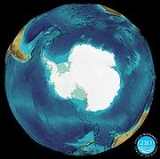
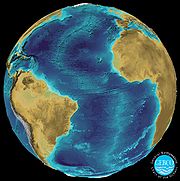
- The GEBCO world map — a global, coloured, paper map of the bathymetry of the world’s oceans based upon the GEBCO One Minute Grid. The map is available to be downloaded in the form of jpeg file.
Project history
The GEBCO chart series was initiated in 1903 by an international group of geographerGeographer
A geographer is a scholar whose area of study is geography, the study of Earth's natural environment and human society.Although geographers are historically known as people who make maps, map making is actually the field of study of cartography, a subset of geography...
s and oceanographers, under the leadership of Prince Albert I of Monaco. At that time there was an explosion of interest in the study of the natural world and this group recognized the importance of a set of maps describing the shape of the ocean floor. The first hundred years of the project were described in the book The History of GEBCO 1903-2003 published by GITC in 2003. Nowadays GEBCO’s role has become increasingly important, due to the increased interest in the oceans for scientific research and for the exploitation and conservation of resources.
Since 1903, five separate editions of paper, bathymetric contour charts covering the whole world have been produced. GEBCO is now maintained in digital form as the GEBCO Digital Atlas.
Training
The Nippon FoundationNippon Foundation
is a private, non-profit grant-making organization. It was established in 1962 by Ryoichi Sasakawa, the late statesman and businessman who, following World War II, was accused, albeit not convicted, of class A war crimes...
of Japan has provided funding for GEBCO to train a new generation of scientists and hydrographers in ocean bathymetry. The 12-month course, leading to a Postgraduate Certificate in Ocean Bathymetry (PCOB), has been held at the University of New Hampshire
University of New Hampshire
The University of New Hampshire is a public university in the University System of New Hampshire , United States. The main campus is in Durham, New Hampshire. An additional campus is located in Manchester. With over 15,000 students, UNH is the largest university in New Hampshire. The university is...
, USA, since 2004. 24 GEBCO scholars from 16 different countries have completed the course and are supporting GEBCO programs.
External links
- GEBCO Digital Atlas
- GEBCO's gridded data sets
- GEBCO world map
- The Academy Of Positioning Marine And Bathymetry (APOMAB)- is an independent, no-profit, no-governmental. It provides a forum for all those involved in activities related to the disciplines of marine positioning and bathymetry members who live or work anywhere in the world.