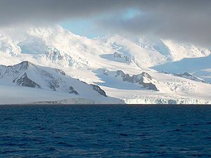
Gela Point
Encyclopedia

Rozhen Peninsula
Rozhen Peninsula extends 9 km in the southwest direction towards Barnard Point, Livingston Island in the South Shetland Islands, Antarctica, and 8.8 km wide. It is bounded by False Bay to the west, Bransfield Strait to the southeast and Brunow Bay to the east...
on Livingston Island, Antarctica formed by an offshoot of Yambol Peak
Yambol Peak
Yambol Peak is a rocky peak rising to 300 m in the south extremity of Friesland Ridge, Tangra Mountains on Livingston Island in the South Shetland Islands, Antarctica and overlooking Tarnovo Ice Piedmont to the west and Prespa Glacier to the northeast. The ice-free surface area of the peak is . ...
. Situated on the coast of Bransfield Strait
Bransfield Strait
Bransfield Strait is a body of water about wide extending for in a general northeast-southwest direction between the South Shetland Islands and Antarctic Peninsula. It was named in about 1825 by James Weddell, Master, Royal Navy, for Edward Bransfield, Master, RN, who charted the South Shetland...
5.1 km east-northeast of Botev Point
Botev Point
Botev Point is the south extremity of both Rozhen Peninsula and Livingston Island in the South Shetland Islands, Antarctica formed by an offshoot of Botev Peak in the Veleka Ridge of Tangra Mountains....
, 700 m east-southeast of Yambol Peak
Yambol Peak
Yambol Peak is a rocky peak rising to 300 m in the south extremity of Friesland Ridge, Tangra Mountains on Livingston Island in the South Shetland Islands, Antarctica and overlooking Tarnovo Ice Piedmont to the west and Prespa Glacier to the northeast. The ice-free surface area of the peak is . ...
, and 4.1 km west-southwest of Samuel Point
Samuel Point
Samuel Point is on the coast of Bransfield Strait forming the southwest side of the entrance to Brunow Bay on Livingston Island in the South Shetland Islands, Antarctica...
. Formed as a result of recent retreat of the adjacent Prespa Glacier
Prespa Glacier
Prespa Glacier on Rozhen Peninsula, Livingston Island in the South Shetland Islands, Antarctica is bounded to the east by Needle Peak and Ludogorie Peak, to the northwest by St. Cyril Peak and St. Methodius Peak, and to the southwest by Shumen Peak and Yambol Peak, and flows southeastward into...
to the northeast. Bulgaria
Bulgaria
Bulgaria , officially the Republic of Bulgaria , is a parliamentary democracy within a unitary constitutional republic in Southeast Europe. The country borders Romania to the north, Serbia and Macedonia to the west, Greece and Turkey to the south, as well as the Black Sea to the east...
n topographic survey Tangra 2004/05
Tangra 2004/05
The Tangra 2004/05 Expedition was commissioned by the Antarctic Place-names Commission at the Ministry of Foreign Affairs of Bulgaria, managed by the Manfred Wörner Foundation, and supported by the Bulgarian Antarctic Institute, the Institute of Mathematics and Informatics at the Bulgarian Academy...
. Named after the settlement of Gela in the central Rhodope Mountains
Rhodope Mountains
The Rhodopes are a mountain range in Southeastern Europe, with over 83% of its area in southern Bulgaria and the remainder in Greece. Its highest peak, Golyam Perelik , is the seventh highest Bulgarian mountain...
, Bulgaria
Bulgaria
Bulgaria , officially the Republic of Bulgaria , is a parliamentary democracy within a unitary constitutional republic in Southeast Europe. The country borders Romania to the north, Serbia and Macedonia to the west, Greece and Turkey to the south, as well as the Black Sea to the east...
.
Maps
- L.L. Ivanov et al. Antarctica: Livingston Island and Greenwich Island, South Shetland Islands. Scale 1:100000 topographic map. Sofia: Antarctic Place-names Commission of Bulgaria, 2005.
- L.L. Ivanov. Antarctica: Livingston Island and Greenwich, Robert, Snow and Smith Islands. Scale 1:120000 topographic map. Troyan: Manfred Wörner Foundation, 2009. ISBN 978-954-92032-6-4

