
Gassaway, West Virginia
Encyclopedia
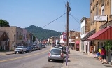
Gassaway is a town in Braxton County, West Virginia
, in the United States
. The population was 901 at the 2000 census. Gassaway was incorporated in 1905 and named for Henry Gassaway Davis. The center of population
of West Virginia is located approximately 7 miles (11 km) north of Gassaway.
was listed on the National Register of Historic Places
in 1994.
.
According to the United States Census Bureau
, the town has a total area of 1.2 square miles (3.2 km²), all land.
of 2000, there were 901 people, 420 households, and 243 families residing in the town. The population density
was 741.5 inhabitants per square mile (285.1/km²). There were 506 housing units at an average density of 416.4 per square mile (160.1/km²). The racial makeup of the town was 98.34% White, 0.55% African American, 0.55% Native American, 0.11% from other races
, and 0.44% from two or more races. Hispanic or Latino of any race were 1.00% of the population.
There were 420 households out of which 21.7% had children under the age of 18 living with them, 45.2% were married couples
living together, 10.0% had a female householder with no husband present, and 42.1% were non-families. 38.8% of all households were made up of individuals and 21.7% had someone living alone who was 65 years of age or older. The average household size was 2.15 and the average family size was 2.87.
In the town the population dispersal was 20.0% under the age of 18, 6.5% from 18 to 24, 23.3% from 25 to 44, 25.0% from 45 to 64, and 25.2% who were 65 years of age or older. The median age was 45 years. For every 100 females there were 82.4 males. For every 100 females age 18 and over, there were 79.8 males. The median income for a household in the town was $23,009, and the median income for a family was $31,667. Males had a median income of $28,125 versus $17,396 for females. The per capita income
for the town was $15,965. About 10.8% of families and 13.9% of the population were below the poverty line, including 10.9% of those under age 18 and 16.9% of those age 65 or over.
weekend features live music, a parade, car show, and fireworks. Visit the link for a schedule of events.
West Virginia
West Virginia is a state in the Appalachian and Southeastern regions of the United States, bordered by Virginia to the southeast, Kentucky to the southwest, Ohio to the northwest, Pennsylvania to the northeast and Maryland to the east...
, in the United States
United States
The United States of America is a federal constitutional republic comprising fifty states and a federal district...
. The population was 901 at the 2000 census. Gassaway was incorporated in 1905 and named for Henry Gassaway Davis. The center of population
Center of population
In demographics, the center of population of a region is a geographical point that describes a centerpoint of the region's population...
of West Virginia is located approximately 7 miles (11 km) north of Gassaway.
History
The Gassaway DepotGassaway Depot
Gassaway Depot, also known as Coal & Coke Railway Company Depot, is a historic railway depot located at Gassaway, Braxton County, West Virginia. It was built in 1914, by the Coal and Coke Railway and later acquired by the Baltimore and Ohio Railroad. It is a two story, brick and stone, Romanesque...
was listed on the National Register of Historic Places
National Register of Historic Places
The National Register of Historic Places is the United States government's official list of districts, sites, buildings, structures, and objects deemed worthy of preservation...
in 1994.
Geography
Gassaway is located at 38°40′15"N 80°46′13"W (38.670712, -80.770413), along the Elk RiverElk River (West Virginia)
The Elk River is a tributary of the Kanawha River, long, in central West Virginia in the United States. Via the Kanawha and Ohio Rivers, it is part of the watershed of the Mississippi River.-Course:...
.
According to the United States Census Bureau
United States Census Bureau
The United States Census Bureau is the government agency that is responsible for the United States Census. It also gathers other national demographic and economic data...
, the town has a total area of 1.2 square miles (3.2 km²), all land.
2000 Census data
As of the censusCensus
A census is the procedure of systematically acquiring and recording information about the members of a given population. It is a regularly occurring and official count of a particular population. The term is used mostly in connection with national population and housing censuses; other common...
of 2000, there were 901 people, 420 households, and 243 families residing in the town. The population density
Population density
Population density is a measurement of population per unit area or unit volume. It is frequently applied to living organisms, and particularly to humans...
was 741.5 inhabitants per square mile (285.1/km²). There were 506 housing units at an average density of 416.4 per square mile (160.1/km²). The racial makeup of the town was 98.34% White, 0.55% African American, 0.55% Native American, 0.11% from other races
Race (United States Census)
Race and ethnicity in the United States Census, as defined by the Federal Office of Management and Budget and the United States Census Bureau, are self-identification data items in which residents choose the race or races with which they most closely identify, and indicate whether or not they are...
, and 0.44% from two or more races. Hispanic or Latino of any race were 1.00% of the population.
There were 420 households out of which 21.7% had children under the age of 18 living with them, 45.2% were married couples
Marriage
Marriage is a social union or legal contract between people that creates kinship. It is an institution in which interpersonal relationships, usually intimate and sexual, are acknowledged in a variety of ways, depending on the culture or subculture in which it is found...
living together, 10.0% had a female householder with no husband present, and 42.1% were non-families. 38.8% of all households were made up of individuals and 21.7% had someone living alone who was 65 years of age or older. The average household size was 2.15 and the average family size was 2.87.
In the town the population dispersal was 20.0% under the age of 18, 6.5% from 18 to 24, 23.3% from 25 to 44, 25.0% from 45 to 64, and 25.2% who were 65 years of age or older. The median age was 45 years. For every 100 females there were 82.4 males. For every 100 females age 18 and over, there were 79.8 males. The median income for a household in the town was $23,009, and the median income for a family was $31,667. Males had a median income of $28,125 versus $17,396 for females. The per capita income
Per capita income
Per capita income or income per person is a measure of mean income within an economic aggregate, such as a country or city. It is calculated by taking a measure of all sources of income in the aggregate and dividing it by the total population...
for the town was $15,965. About 10.8% of families and 13.9% of the population were below the poverty line, including 10.9% of those under age 18 and 16.9% of those age 65 or over.
External links
Gassaway Days celebration on the 4th of JulyIndependence Day (United States)
Independence Day, commonly known as the Fourth of July, is a federal holiday in the United States commemorating the adoption of the Declaration of Independence on July 4, 1776, declaring independence from the Kingdom of Great Britain...
weekend features live music, a parade, car show, and fireworks. Visit the link for a schedule of events.