

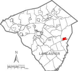
Gap, Pennsylvania
Encyclopedia
Census-designated place
A census-designated place is a concentration of population identified by the United States Census Bureau for statistical purposes. CDPs are delineated for each decennial census as the statistical counterparts of incorporated places such as cities, towns and villages...
and town in Salisbury Township
Salisbury Township, Lancaster County, Pennsylvania
Salisbury Township is a township in east central Lancaster County, Pennsylvania, United States. The population was 10,012 at the 2000 census.Salisbury Township was carved out of Pequea Township in 1729 and named for Salisbury, England...
, Lancaster County, Pennsylvania
Lancaster County, Pennsylvania
Lancaster County, known as the Garden Spot of America or Pennsylvania Dutch Country, is a county located in the southeastern part of the Commonwealth of Pennsylvania, in the United States. As of 2010 the population was 519,445. Lancaster County forms the Lancaster Metropolitan Statistical Area, the...
with a zip code
ZIP Code
ZIP codes are a system of postal codes used by the United States Postal Service since 1963. The term ZIP, an acronym for Zone Improvement Plan, is properly written in capital letters and was chosen to suggest that the mail travels more efficiently, and therefore more quickly, when senders use the...
of 17527. The population was 1,611 at the 2000 census. It is the terminus for four Pennsylvania highways: 772
Pennsylvania Route 772
Pennsylvania Route 772 or is an east–west long state highway located in Lancaster County, Pennsylvania. It is a scenic alternative to U.S. Route 30 as it roughly parallels the main highway to the north. The highway is mostly named Newport Road...
, 741
Pennsylvania Route 741
Pennsylvania Route 741 is a long state highway that runs through western and southern Lancaster County in the U.S. state of Pennsylvania. The eastern terminus is at Pennsylvania Route 41 in Gap...
, 897
Pennsylvania Route 897
Pennsylvania Route 897 is a long north–south route in eastern Pennsylvania, United States. The southern terminus is at an intersection with U.S. Route 30 in Gap. The northern terminus is at U.S. Route 422 east of Lebanon. Like most Pennsylvania highways, PA 897 has no expressway...
, and the heavily-used 41
Pennsylvania Route 41
Pennsylvania Route 41 is a major long state highway located in southeastern Pennsylvania. The southern terminus of the route is at the Delaware state line in New Garden Township, where it continues as Delaware Route 41. The northern terminus is at U.S...
, which goes toward Wilmington, DE.
History
Gap has a history which can be dated as far back as William Penn's first visits to the area. Isaac Taylor erected the first house in what would become the Gap in 1747. The area around Gap had a copper mine and what at the time was the only nickel mines in the United States. The town was named after The Gap in the Appalachian MountainsAppalachian Mountains
The Appalachian Mountains #Whether the stressed vowel is or ,#Whether the "ch" is pronounced as a fricative or an affricate , and#Whether the final vowel is the monophthong or the diphthong .), often called the Appalachians, are a system of mountains in eastern North America. The Appalachians...
.
A stretch of railroad line was laid through areas of Sadsbury Township and Salisbury Township, which portions of each township share the Gap ZIP code
ZIP Code
ZIP codes are a system of postal codes used by the United States Postal Service since 1963. The term ZIP, an acronym for Zone Improvement Plan, is properly written in capital letters and was chosen to suggest that the mail travels more efficiently, and therefore more quickly, when senders use the...
(17527) and the town name of Gap.
Roads
Pequea Avenue is among the most heavily-traveled roads in Gap. The Gap Fire Co. is located along this street. Gap Fire Company. The fire company was originally located atop Pequea Avenue by their water refilling area. The original fire house was renovated into a home that is leased out. A new facility was built to house all of the rescue trucks. the fire house is also used to host many fundraisers and civic gatherings. Up the street another block is a very historic building which was used for the Pequea Feeds Company. The building is located directly next to the Gap Railroad station. About another block away you would find the previous home of community radio station WLRI 92.9 "WLRI 93FM". Until July 2008 WLRI Studios were used to broadcast local news, weather and traffic information.Pennsylvania Route 41
Pennsylvania Route 41
Pennsylvania Route 41 is a major long state highway located in southeastern Pennsylvania. The southern terminus of the route is at the Delaware state line in New Garden Township, where it continues as Delaware Route 41. The northern terminus is at U.S...
connects central Gap to Newport, Delaware
Newport, Delaware
Newport is a town in New Castle County, Delaware, United States. It is located on the Christina River. It is best known for being the home of colonial inventor Oliver Evans. The population was 1,055 at the 2010 census...
and begins a block east of Pequea Avenue at the intersection of US 30, also known as the Lincoln Highway
Lincoln Highway
The Lincoln Highway was the first road across the United States of America.Conceived and promoted by entrepreneur Carl G. Fisher, the Lincoln Highway spanned coast-to-coast from Times Square in New York City to Lincoln Park in San Francisco, originally through 13 states: New York, New Jersey,...
. PA 41 is the highway that connects the North to the South. It is a very relied-on route for commercial transporters who do not want to travel out to Philadelphia's bridges to deliver goods to the Northern states. In 1997 a study was conducted which said that PA 41 is the 3rd most deadly highway in the United States. Following a PennDOT conducted survey, improvements have been planned starting in 2014.
Pennsylvania Route 772
Pennsylvania Route 772
Pennsylvania Route 772 or is an east–west long state highway located in Lancaster County, Pennsylvania. It is a scenic alternative to U.S. Route 30 as it roughly parallels the main highway to the north. The highway is mostly named Newport Road...
Starts in Gap about 5 blocks west from the intersection of PA 41 and US 30 along Lincoln Highway
Lincoln Highway
The Lincoln Highway was the first road across the United States of America.Conceived and promoted by entrepreneur Carl G. Fisher, the Lincoln Highway spanned coast-to-coast from Times Square in New York City to Lincoln Park in San Francisco, originally through 13 states: New York, New Jersey,...
Route 772 is popular with visitors to view local farms and farm lands. The road will take you northwest near Mount Joy
Mount Joy, Pennsylvania
Mount Joy is a borough in Lancaster County, Pennsylvania, United States. The population was 6,765 at the 2000 census.-Name and origin:Mount Joy is often named in lists of "delightfully-named towns" in Pennsylvania Dutchland, along with Intercourse, Blue Ball, PenisPallooza, Amish Land, Dick-in-Hand...
. As you travel along PA 772 you will go through towns such as Intercourse
Intercourse, Pennsylvania
Intercourse, Pennsylvania is an unincorporated village in Leacock Township, Lancaster County in the U.S. state of Pennsylvania, ten miles east of Lancaster on PA 340. As with the nearby towns of Bird-in-Hand, Blue Ball, and Paradise, Intercourse is a popular site for tourists because of its...
; Leola; New Holland
New Holland, Pennsylvania
New Holland is a borough in Lancaster County in Pennsylvania, USA. The population was 5,092 at the 2000 census. New Holland was settled in 1728 by John Michael and John Phillip Ranc . Before it became known as New Holland, it had been called Hog Swamp, Earltown and New Design...
; and Ephrata
Ephrata, Pennsylvania
Ephrata is a borough in Lancaster County, Pennsylvania, United States, south east of Harrisburg and about west by north of Philadelphia. It is named after Ephrath, a biblical town in what is now Israel. Ephrata's sister city is Eberbach, Germany, the city where its founders originated. In its...
.
Pennsylvania Route 897
Pennsylvania Route 897
Pennsylvania Route 897 is a long north–south route in eastern Pennsylvania, United States. The southern terminus is at an intersection with U.S. Route 30 in Gap. The northern terminus is at U.S. Route 422 east of Lebanon. Like most Pennsylvania highways, PA 897 has no expressway...
starts in Gap one block east from PA 41 at the intersection of US 30. Many residents and merchants choose to avoid this route simply because of the Welsh mountain of which the highway was paved upon. Many tourists use the PA 897 corridor to travel North to Reading
Reading, Pennsylvania
Reading is a city in southeastern Pennsylvania, USA, and seat of Berks County. Reading is the principal city of the Greater Reading Area and had a population of 88,082 as of the 2010 census, making it the fifth most populated city in the state after Philadelphia, Pittsburgh, Allentown and Erie,...
. PA 897 travels through such towns as: Cambridge, Narvon and Myerstown.
Pennsylvania Route 741
Pennsylvania Route 741
Pennsylvania Route 741 is a long state highway that runs through western and southern Lancaster County in the U.S. state of Pennsylvania. The eastern terminus is at Pennsylvania Route 41 in Gap...
starts at the intersection of PA 41 and Bridge Street. The route extends westbound to Millersville
Millersville, Pennsylvania
Millersville is a borough in Lancaster County, Pennsylvania, United States. At the 2000 census the population was 7,774.-Geography:Millersville is located at ....
.
The Gap Gang
In the mid 19th century there was a group of men known as "The Gap Gang". They would engage in raids and robberies of citizens traveling the Lancaster Philadelphia Turnpike. They were notoriously known for kidnapping free blacks, and escaped slaves and selling them back to slave traders in Maryland, Delaware, and Virginia. The Gap Gang were most noted for their involvement in the Christiana Riot.(For further reading of the Christiana Riot and "The Gap Gang", please see this NY Times article from August 15, 1888 TRIED FOR HIGH TREASON; A CELEBRATED INCIDENT OF THE FUGITIVE SLAVE LAW. CITIZENS OF LANCASTER COUNTY, PENN., WILL CELEBRATE AN EVENT WHICH HAS BECOME HISTORICAL. )
Geography
Gap is located at 39°59′14"N 76°1′9"W (39.987360, -76.019254).According to the United States Census Bureau
United States Census Bureau
The United States Census Bureau is the government agency that is responsible for the United States Census. It also gathers other national demographic and economic data...
, the CDP has a total area of 2.8 square miles (7.3 km²), all of it land.
Demographics
Census
A census is the procedure of systematically acquiring and recording information about the members of a given population. It is a regularly occurring and official count of a particular population. The term is used mostly in connection with national population and housing censuses; other common...
of 2000, there were 1,611 people, 572 households, and 459 families residing in the CDP. The population density
Population density
Population density is a measurement of population per unit area or unit volume. It is frequently applied to living organisms, and particularly to humans...
was 576.5 people per square mile (222.9/km²). There were 597 housing units at an average density of 213.6/sq mi (82.6/km²). The racial makeup of the CDP was 97.89% White, 0.43% Black or African American
Race (United States Census)
Race and ethnicity in the United States Census, as defined by the Federal Office of Management and Budget and the United States Census Bureau, are self-identification data items in which residents choose the race or races with which they most closely identify, and indicate whether or not they are...
, 0.06% Native American, 1.06% Asian, 0.12% Pacific Islander, 0.12% from other races
Race (United States Census)
Race and ethnicity in the United States Census, as defined by the Federal Office of Management and Budget and the United States Census Bureau, are self-identification data items in which residents choose the race or races with which they most closely identify, and indicate whether or not they are...
, and 0.31% from two or more races. 0.81% of the population were Hispanic or Latino of any race.
There were 572 households out of which 38.8% had children under the age of 18 living with them, 68.7% were married couples
Marriage
Marriage is a social union or legal contract between people that creates kinship. It is an institution in which interpersonal relationships, usually intimate and sexual, are acknowledged in a variety of ways, depending on the culture or subculture in which it is found...
living together, 7.2% had a female householder with no husband present, and 19.6% were non-families. 16.4% of all households were made up of individuals and 5.8% had someone living alone who was 65 years of age or older. The average household size was 2.82 and the average family size was 3.14.
In the CDP the population was spread out with 29.4% under the age of 18, 7.1% from 18 to 24, 29.7% from 25 to 44, 23.7% from 45 to 64, and 10.1% who were 65 years of age or older. The median age was 36 years. For every 100 females there were 98.2 males. For every 100 females age 18 and over, there were 95.9 males.
The median income for a household in the CDP was $46,036, and the median income for a family was $51,181. Males had a median income of $38,958 versus $24,803 for females. The per capita income
Per capita income
Per capita income or income per person is a measure of mean income within an economic aggregate, such as a country or city. It is calculated by taking a measure of all sources of income in the aggregate and dividing it by the total population...
for the CDP was $18,052. About 4.4% of families and 4.3% of the population were below the poverty line, including none of those under age 18 and 19.5% of those age 65 or over.
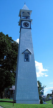
Attractions
The Gap Town Clock, built in 1892, is a Lancaster County Historic Preservation Trust Site located in Gap. According to the Gap Clock Tower Association, "The clock's face, long telling the time to passing multitudes, overlooks, at the gap, William Penns' entrance into Conestoga, now Lancaster County, in 1701."Media
Gap is served by the radio station WLRIWLRI-LP
WLRI-LP is a low-power FM radio station licensed to serve Gap, Pennsylvania. The station is owned by LanChester Radio Information, Inc., and the broadcast license is held by Octave Communications Association...
93FM, a Licensed Non-Commercial Educational outlet for Community based Public Media. The station is the region, county and state's only 24 Hour All News station with funding provided by local businesses.