
GR 20
Encyclopedia
GR footpath
The Grande Randonnée , Grote Routepaden or Lange-afstand-wandelpaden , Grande Rota or Gran Recorrido is a network of long-distance footpaths in Europe, mostly in France, Belgium, the Netherlands and Spain. In France alone, the trails cover approximately 60,000 km...
that crosses the Mediterranean
Mediterranean Sea
The Mediterranean Sea is a sea connected to the Atlantic Ocean surrounded by the Mediterranean region and almost completely enclosed by land: on the north by Anatolia and Europe, on the south by North Africa, and on the east by the Levant...
island
Island
An island or isle is any piece of sub-continental land that is surrounded by water. Very small islands such as emergent land features on atolls can be called islets, cays or keys. An island in a river or lake may be called an eyot , or holm...
of Corsica
Corsica
Corsica is an island in the Mediterranean Sea. It is located west of Italy, southeast of the French mainland, and north of the island of Sardinia....
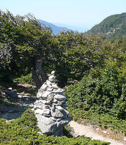
running approximately north-south, described by the outdoor writer Paddy Dillon as "one of the top trails in the world". The GR 20 is marked regularly with distinctive red and white waymarks, which in good weather are simple to follow, yet in the early and late season when the ground is usually still covered in snow, or when walking in cloud, the path may become harder to follow. In some of the more exposed scrambles, ladders and steel ropes have been fixed into the rock surface to aid walkers (though this is only for a very short section in the "Cirque de la Solitude"). Although the northern section of the route requires some moderate scrambling, the majority of the GR 20 is a well worn footpath and its main challenge comes not from its ruggedness, but from its length. Being at high altitude, some snow can come late and early in the year and fog can bring a bitter chill and make it difficult to find one's way also some of the ridges are prone to very high winds. Despite the main path being marked by waymarks and being well worn, there are also routes that lead down from the main path into villages, or up from the path to peaks.
 |
 |
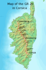
The whole trail is about 180 km long, clearly waymarked throughout, the walk for most people takes around 15 days. The trail is usually considered as two parts: the northern part, between Calenzana
Calenzana
Calenzana is a commune in the Haute-Corse department of France on the island of Corsica.In 1732 it was the site of an uprising by Corsican nationalists against the island's Genoese rulers....
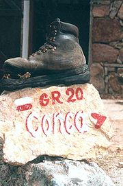
and Vizzavona and the southern part, between Vizzavona and Conca
Conca, Corse-du-Sud
Conca is a commune in the Corse-du-Sud department of France on the island of Corsica.-Population:-References:*...
.
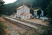
Vizzavona is considered the middle as there is a train station, and therefore is an accessible point for walkers beginning or ending a walk consisting of half the route. From Vizzavona, the train can be taken to Bastia
Bastia
Bastia is a commune in the Haute-Corse department of France located in the northeast of the island of Corsica at the base of Cap Corse. It is also the second-largest city in Corsica after Ajaccio and the capital of the department....
or Ajaccio
Ajaccio
Ajaccio , is a commune on the island of Corsica in France. It is the capital and largest city of the region of Corsica and the prefecture of the department of Corse-du-Sud....
as well as many smaller towns and villages such as Corte
Corte
Corte is a commune in the Haute-Corse department of France on the island of Corsica. It is the fourth-largest commune in Corsica .-Administration:Corte is a subprefecture of the Haute-Corse department.-History:...
. The northern part is considered by some the more difficult part, because of the steep and rocky paths, though this could be an effect of many walkers beginning in the north and not being as fit for this section. The southern part of the trail is often considered easier though the lower altitude may give rise to higher temperatures in summer and so provide more difficult walking conditions.
Along the trail there are mountain huts described as "refuges" or gîte
Gîte
"Gîte" is a French term which refers to a specific type of holiday accommodation. A "Gîte" is a holiday home that is available for rent. Gîtes are usually fully furnished and equipped for self-catering...
s. The standard and price of accommodations and food varies from refuge to refuge. One can sleep in a tent near the refuge, but it is not permitted to pitch tents along the trail.
The GR 20 is an advanced trail. Of the less difficult but beautiful trails on the island two Mare e monti (from sea to mountain) and three Mare a mare (from sea to sea) trails are the best known.
Route
- Northern part: CalenzanaCalenzanaCalenzana is a commune in the Haute-Corse department of France on the island of Corsica.In 1732 it was the site of an uprising by Corsican nationalists against the island's Genoese rulers....
- Ortu di Piobbu or Bonifatu (alternative route) - Carozzu - Asco Stagnu - Tighjettu - Ciottulu di I Mori (or Castel de Vergio) - Manganu - Petra Piana - L'Onda - Vizzavona
- Southern part: Vizzavona - E Capenelle - I Prati - Usciulu - Asinao - I Paliri - ConcaConca, Corse-du-SudConca is a commune in the Corse-du-Sud department of France on the island of Corsica.-Population:-References:*...
External links
- www.gr20.be
- GR 20 on the official website of the Parc naturel régional de Corse (in French)
- GR 20 route planning - comprehensive information for hikers, maps, GPS files, photos and a very informative video (on the northern section of the GR 20): Memories of a Trekker
- An index (in French) of the multiple personal pages relating a trek along GR 20
- An index (in Italian) of the handbook for a trek "GR 20"
- GR20 in October