
Fulham Railway Bridge
Encyclopedia
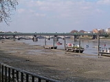
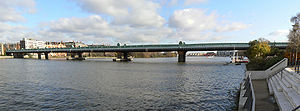
Fulham Railway Bridge crosses the River Thames
in London
. It is very close to Putney Bridge
, and carries the London Underground
District Line
between Putney Bridge station
on the North, and East Putney station
on the South. Fulham Railway Bridge can also be crossed on foot, on the downstream (east) side.
's former assistant William Jacomb, built by Head Wrightson and opened in 1889.
which are the nearest rail bridges upstream and downstream respectively, Fulham Railway Bridge is absent from many global online mapping services such as Google Maps . Consequently any users of these services planning a journey by foot which sees them cross the river near Putney Railway Bridge are liable to take an unnecessary detour to nearby Putney Bridge
. The bridge is however visible on online mapping services based on Ordnance Survey
data, such as Bing Maps UK .
River Thames
The River Thames flows through southern England. It is the longest river entirely in England and the second longest in the United Kingdom. While it is best known because its lower reaches flow through central London, the river flows alongside several other towns and cities, including Oxford,...
in London
London
London is the capital city of :England and the :United Kingdom, the largest metropolitan area in the United Kingdom, and the largest urban zone in the European Union by most measures. Located on the River Thames, London has been a major settlement for two millennia, its history going back to its...
. It is very close to Putney Bridge
Putney Bridge
Putney Bridge is a bridge crossing of the River Thames in west London, linking Putney on the south side with Fulham to the north. Putney Bridge tube station is located near the north side of the bridge.-History:...
, and carries the London Underground
London Underground
The London Underground is a rapid transit system serving a large part of Greater London and some parts of Buckinghamshire, Hertfordshire and Essex in England...
District Line
District Line
The District line is a line of the London Underground, coloured green on the Tube map. It is a "sub-surface" line, running through the central area in shallow cut-and-cover tunnels. It is the busiest of the sub-surface lines. Out of the 60 stations served, 25 are underground...
between Putney Bridge station
Putney Bridge tube station
Putney Bridge is a London Underground station on the branch of the District Line. It is between and stations and is in Zone 2. The station is located in the south of Fulham, adjacent to Fulham High Street and New Kings Road and is a short distance from the north end of Putney Bridge from which...
on the North, and East Putney station
East Putney tube station
East Putney is a London Underground station on the branch of the District line. It is between to the north, and to the south. The station is on Upper Richmond Road...
on the South. Fulham Railway Bridge can also be crossed on foot, on the downstream (east) side.
History
The bridge is of lattice girder construction and 418 metres long, with 5 spans totalling 301 metres actually across the river, two further spans on the southern shore, and one on the north. It was designed by BrunelIsambard Kingdom Brunel
Isambard Kingdom Brunel, FRS , was a British civil engineer who built bridges and dockyards including the construction of the first major British railway, the Great Western Railway; a series of steamships, including the first propeller-driven transatlantic steamship; and numerous important bridges...
's former assistant William Jacomb, built by Head Wrightson and opened in 1889.
Absence from Online Mapping services
Unlike Barnes Railway Bridge and Battersea Railway BridgeBattersea Railway Bridge
The Battersea Railway Bridge - properly called the Cremorne Bridge, after the pleasure grounds in Chelsea and originally commonly referred to as the Battersea New Bridge - is a bridge across the River Thames in London, between Battersea and Chelsea and forming part of the West London Line of the...
which are the nearest rail bridges upstream and downstream respectively, Fulham Railway Bridge is absent from many global online mapping services such as Google Maps . Consequently any users of these services planning a journey by foot which sees them cross the river near Putney Railway Bridge are liable to take an unnecessary detour to nearby Putney Bridge
Putney Bridge
Putney Bridge is a bridge crossing of the River Thames in west London, linking Putney on the south side with Fulham to the north. Putney Bridge tube station is located near the north side of the bridge.-History:...
. The bridge is however visible on online mapping services based on Ordnance Survey
Ordnance Survey
Ordnance Survey , an executive agency and non-ministerial government department of the Government of the United Kingdom, is the national mapping agency for Great Britain, producing maps of Great Britain , and one of the world's largest producers of maps.The name reflects its creation together with...
data, such as Bing Maps UK .
Further reading
- Chris Roberts: Cross River Traffic: A history of London's Bridges, Granta 2006 ISBN 1-86207-884-X, ISBN 978-1-86207-884-0