
Frankfort, Michigan
Encyclopedia
Frankfort is a city in Benzie County
in the U.S. state
of Michigan
. The population was 1,513 at the 2000 census
. The elevation of Frankfort is 600 ft (182.9 m) above sea level. The city is situated with Lake Michigan
to the west, Lake Betsie, formed by the Betsie River
before flowing into Lake Michigan, on the south and Crystal Lake Township
to the north and east. The city is on M-22
just north of Elberta
. M-115
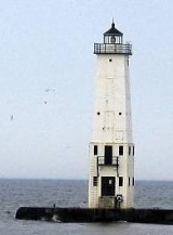
has its western terminus in the city. The Frankfort North Breakwater Lighthouse is at the end of the northern breakwater in Lake Michigan.
of 2000, there were 1,513 people, 665 households, and 395 families residing in the city. The population density
was 1,084.4 per square mile (417.3/km²). There were 873 housing units at an average density of 625.7 per square mile (240.8/km²). The racial makeup of the city was 95.84% White, 0.33% African American, 2.31% Native American, 0.26% Asian, 0.13% from other races
, and 1.12% from two or more races. Hispanic or Latino of any race were 1.78% of the population.
There were 665 households out of which 20.9% had children under the age of 18 living with them, 46.9% were married couples
living together, 9.6% had a female householder with no husband present, and 40.6% were non-families. 36.1% of all households were made up of individuals and 21.4% had someone living alone who was 65 years of age or older. The average household size was 2.11 and the average family size was 2.71.
In the city the population was spread out with 17.9% under the age of 18, 6.3% from 18 to 24, 20.8% from 25 to 44, 23.7% from 45 to 64, and 31.2% who were 65 years of age or older. The median age was 49 years. For every 100 females there were 78.2 males. For every 100 females age 18 and over, there were 76.2 males.
The median income for a household in the city was $33,821, and the median income for a family was $43,375. Males had a median income of $29,205 versus $21,389 for females. The per capita income
for the city was $20,132. About 6.6% of families and 10.2% of the population were below the poverty line, including 13.6% of those under age 18 and 9.1% of those age 65 or over.
History
Father Jacques Marquette, one of the first Jesuit missionaries to the Great Lakes Indians, may have died and been buried in Frankfort in May of 1675. Very limited and inexact records make the death site a matter of considerable debate among historians. Frankfort is one of two locations attributed as the death site by the natives since the earliest settlers arrived in northern Michigan and one of at least two sites claimed by historians. In any case within two years the remains were taken to the church at St. Ignace and given a traditional Indian burial.
The land which was to become the City of Frankfort was recognized at an early date for its economic and commercial potential because it was nearly all purchased by the contractors who surveyed the land for the United States - - the Risdon family. The first known settler in Frankfort was Joseph Oliver who purchased the 14 acres (56,656 m²) between Lake Aux Becs Scies and Lake Michigan in 1852 and built a small cabin. Oliver was a woodsman who lived off the land: fishing, hunting, trapping and cutting timber. In 1855 a schooner owned by George W. Tifft of Cleveland was caught in a gale on Lake Michigan and driven before the wind. Imagine the surprise of Captain Snow when he found a previously little known river outlet and harbor which provided a safe refuge. Thus, Aux Becs Scies Lake was discovered by an outside investor, George W. Tifft, who purchased most of the land around and adjoining the lake (more than a thousand acres (4 km²) all together). In 1859 a company from Detroit owned by Ransom Gardiner, George S. Frost, and others purchased the Tifft lands and commenced development of Frankfort within the year. In September, Louis A. Doby moved to the area as agent of the developers with John H. Adams to oversee the work. They sent along a sawmill and A.S. Dow to manage that phase of the development. Descendants of the Dow family—founders of the Dow Chemical Company—are unaware of any relationship to A.S. Dow. Doby held a contract to dredge a new channel so the harbor would be available for navigation by all types of craft. He also constructed a building for the firm which served as a hotel and store. The first lot in the development near the west end of Forest Avenue was sold to William H. Cogshall. He built a large home for his family but his dwelling also served the fledgling community as a hotel and for religious and political meetings. The second lot, also at the west end of Forest Avenue, was purchased by Dr. Alonzo J. Slyfield, who served for 22 years as keeper of the Point Betsie Light House. Although the development had a promising start there was relatively little activity during the Civil War years. Virtually all of this early development took place in the area of First, Second, Third, Fourth, and Main Streets and Forest Avenue.
By 1867 the United States government recognized the importance of Aux Becs Scies harbor and commenced improvements. Doby’s work from 1859 had completely disappeared and a channel was dredged at the south end of the strip of land dividing the two lakes. Shortly an enthusiastic newspaperman reported four to ten vessel arrivals a day and new settlers in droves. Stores were built and a large hotel, the Delbridge House, opened for business. A post office had been established in 1860 with Cogshall as postmaster but was eventually closed for want of business. This was reopened in 1867 with N.W. Nelson postmaster. Among the other early settlers were Jacob and Charles Voorhies, J.B. Delbridge, Dr. T. Harvey, and J.B. Collins who opened his drug store in 1869.
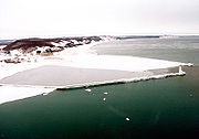
Although the initial opening of the harbor was in 1867 the work was actually ongoing for several years. By 1870 the channel was 200 feet (61 m) wide and had a south pier of 600 feet (182.9 m) while the north one measured 550 feet (167.6 m). A depth of about nine feet was maintained which allowed most of the vessels on the Great Lakes to enter the harbor. In 1873, the United States Lighthouse Service established the first pier head light to mark the entrance. In 1887 a United States Life Saving Station was established on the south side of the harbor. In 1934, as the United States Coast Guard, this station was moved to large new quarters on the Frankfort side of the channel. The original piers had been extended until they reached a length of 2000 feet (609.6 m) in 1912. Between 1929 and 1932 the breakwaters were built to protect the harbor at a cost of over a million dollars and the old piers were reduced in length.
Crystal Lake Township was organized in 1859 and initially included all of the present Benzie County. The first Township meeting was held in the spring of 1860 at Frankfort in Doby’s (the development company) store. The Benzie County government was organized by Public Act 385 of 1869 and local citizens set off in search of a county seat and a courthouse. After two elections, Frankfort was chosen and the Supervisors met in the community for the first time in April 1870. Although the first session was held in the Saterlee Hotel later sessions were held in a two story commercial building on the corner of Second and Main Streets. However, in 1872 new elections were held and citizens of the county decided to move the county seat into the country side east of Benzonia. Frankfort contested the move and managed to retain the seat of government, at least in name, until 1876. Following another election in 1894, the county seat returned to the community and a large school building was converted to a courthouse. Although the matter was frequently debated the county seat remained in Frankfort until 1908 when citizens voted to move it to an abandoned church in the Village of Honor.
In October 1873, the citizens of Frankfort unanimously petitioned the circuit court to become a village under a new act of the State Legislature. The petition was granted but the effort failed when the State Act was declared unconstitutional. In 1885 the citizens petitioned the State Legislature in the normal fashion and the incorporated village of Frankfort was established by Local Act No. 352 of 1885 on April 1 and by Local Act No. 352 of 1885 on May 14. (Legal boundaries of Frankfort are: Government Lots 2, 3, and 4 of Section 21; the Southeast Quarter of the Northeast Quarter of Section 21; the South Half of the North Half of Section 22; Government Lots 1, 2, 3, and 4 of Section 27; and the Northwest Fractional Quarter of Section 28 of Township No. 26 North of Range No. 16 West.)
Frankfort has enjoyed a steady growth over the years and by the 1930s had reached a population whereby they could become a city. Accordingly, voters of the village elected to become a city of the fifth class on March 11, 1935, with 229 votes in favor and 127 against. There was no change in the boundaries of the original village.
Benzie County, Michigan
-Demographics:As of the 2000 census, there were 15,998 people, 6,500 households, and 4,595 families residing in the county. The population density was 50 people per square mile . There were 10,312 housing units at an average density of 32 per square mile...
in the U.S. state
U.S. state
A U.S. state is any one of the 50 federated states of the United States of America that share sovereignty with the federal government. Because of this shared sovereignty, an American is a citizen both of the federal entity and of his or her state of domicile. Four states use the official title of...
of Michigan
Michigan
Michigan is a U.S. state located in the Great Lakes Region of the United States of America. The name Michigan is the French form of the Ojibwa word mishigamaa, meaning "large water" or "large lake"....
. The population was 1,513 at the 2000 census
United States Census, 2000
The Twenty-second United States Census, known as Census 2000 and conducted by the Census Bureau, determined the resident population of the United States on April 1, 2000, to be 281,421,906, an increase of 13.2% over the 248,709,873 persons enumerated during the 1990 Census...
. The elevation of Frankfort is 600 ft (182.9 m) above sea level. The city is situated with Lake Michigan
Lake Michigan
Lake Michigan is one of the five Great Lakes of North America and the only one located entirely within the United States. It is the second largest of the Great Lakes by volume and the third largest by surface area, after Lake Superior and Lake Huron...
to the west, Lake Betsie, formed by the Betsie River
Betsie River
The Betsie River is a stream in the northwest part of the U.S. state of Michigan. The name is derived from the French Riviere Aux Bec Scies, meaning river of sawbill ducks . Other alternate names include Aug-sig-o-sebe, Aux Buscies, Betsey's River, Black Robe, Gay-she-say-ing, Riviere du Pere...
before flowing into Lake Michigan, on the south and Crystal Lake Township
Crystal Lake Township, Michigan
Crystal Lake Township is a civil township of Benzie County in the U.S. state of Michigan. The population was 960 at the 2000 census. The township has an irregular shape running along Lake Michigan north of city of Frankfort to Crystal Lake, running southeast through the lake to Benzonia Township,...
to the north and east. The city is on M-22
M-22 (Michigan highway)
M-22 is a state trunkline highway in the US state of Michigan. It is long and follows the Lake Michigan shoreline of the Leelanau Peninsula, making up a portion of the Lake Michigan Circle Tour. It also passes through the Sleeping Bear Dunes National Lakeshore...
just north of Elberta
Elberta, Michigan
Elberta is a village in Benzie County in the U.S. state of Michigan. The population was 457 at the 2000 census. The village located in the east of Gilmore Township, on the south side of Lake Betsie, which is formed by the Betsie River before flowing into Lake Michigan. The village is on M-22 just...
. M-115
M-115 (Michigan highway)
M-115 is a state trunkline highway in the northwestern part of the Lower Peninsula of the US state of Michigan. The highway takes a generally southeast-to-northwest direction between Clare and Frankfort on Lake Michigan...
has its western terminus in the city. The Frankfort North Breakwater Lighthouse is at the end of the northern breakwater in Lake Michigan.
Geography
- According to the United States Census BureauUnited States Census BureauThe United States Census Bureau is the government agency that is responsible for the United States Census. It also gathers other national demographic and economic data...
, the city has a total area of 1.6 square miles (4.1 km²), of which, 1.4 square miles (3.6 km²) of it is land and 0.2 square mile (0.517997622 km²) of it (11.95%) is water. - Frankfort bills itself as the gateway to the Sleeping Bear Dunes National LakeshoreSleeping Bear Dunes National LakeshoreSleeping Bear Dunes National Lakeshore is a United States National Lakeshore located along the northwest coast of the Lower Peninsula of Michigan in Leelanau County and Benzie County....
. - Frankfort is considered to be part of Northern MichiganNorthern MichiganNorthern Michigan, also known as Northern Lower Michigan , is a region of the U.S. state of Michigan...
. - The Point Betsie LightPoint Betsie Light-Specialized further reading:* Hawley, Jonathon P., Point Betsie: Lightkeeping and Lifesaving on Northeastern Lake Michigan 264 p., 61 B&W photos ISBN 9780472033188.- External links :* * * * * by LighthousesRus...
is in the area and has been in operation for 150 years. It and is locally operated and maintained, and is undergoing a complete renovation. - The town is close to the Interlochen State ParkInterlochen State ParkInterlochen State Park is the State of Michigan's first officially recognized state park. Situated between two freshwater lakes , it is a popular camping destination. It was established by the Michigan Legislature in 1917; $60,000 was paid for the land...
, which is one of two remaining stands of virgin Eastern White PineEastern White PinePinus strobus, commonly known as the eastern white pine, is a large pine native to eastern North America, occurring from Newfoundland west to Minnesota and southeastern Manitoba, and south along the Appalachian Mountains to the northern edge of Georgia.It is occasionally known as simply white pine,...
in the Lower Peninsula.
Highways
 M-22M-22 (Michigan highway)M-22 is a state trunkline highway in the US state of Michigan. It is long and follows the Lake Michigan shoreline of the Leelanau Peninsula, making up a portion of the Lake Michigan Circle Tour. It also passes through the Sleeping Bear Dunes National Lakeshore...
 M-115M-115 (Michigan highway)M-115 is a state trunkline highway in the northwestern part of the Lower Peninsula of the US state of Michigan. The highway takes a generally southeast-to-northwest direction between Clare and Frankfort on Lake Michigan...
Demographics
As of the censusCensus
A census is the procedure of systematically acquiring and recording information about the members of a given population. It is a regularly occurring and official count of a particular population. The term is used mostly in connection with national population and housing censuses; other common...
of 2000, there were 1,513 people, 665 households, and 395 families residing in the city. The population density
Population density
Population density is a measurement of population per unit area or unit volume. It is frequently applied to living organisms, and particularly to humans...
was 1,084.4 per square mile (417.3/km²). There were 873 housing units at an average density of 625.7 per square mile (240.8/km²). The racial makeup of the city was 95.84% White, 0.33% African American, 2.31% Native American, 0.26% Asian, 0.13% from other races
Race (United States Census)
Race and ethnicity in the United States Census, as defined by the Federal Office of Management and Budget and the United States Census Bureau, are self-identification data items in which residents choose the race or races with which they most closely identify, and indicate whether or not they are...
, and 1.12% from two or more races. Hispanic or Latino of any race were 1.78% of the population.
There were 665 households out of which 20.9% had children under the age of 18 living with them, 46.9% were married couples
Marriage
Marriage is a social union or legal contract between people that creates kinship. It is an institution in which interpersonal relationships, usually intimate and sexual, are acknowledged in a variety of ways, depending on the culture or subculture in which it is found...
living together, 9.6% had a female householder with no husband present, and 40.6% were non-families. 36.1% of all households were made up of individuals and 21.4% had someone living alone who was 65 years of age or older. The average household size was 2.11 and the average family size was 2.71.
In the city the population was spread out with 17.9% under the age of 18, 6.3% from 18 to 24, 20.8% from 25 to 44, 23.7% from 45 to 64, and 31.2% who were 65 years of age or older. The median age was 49 years. For every 100 females there were 78.2 males. For every 100 females age 18 and over, there were 76.2 males.
The median income for a household in the city was $33,821, and the median income for a family was $43,375. Males had a median income of $29,205 versus $21,389 for females. The per capita income
Per capita income
Per capita income or income per person is a measure of mean income within an economic aggregate, such as a country or city. It is calculated by taking a measure of all sources of income in the aggregate and dividing it by the total population...
for the city was $20,132. About 6.6% of families and 10.2% of the population were below the poverty line, including 13.6% of those under age 18 and 9.1% of those age 65 or over.
Economy and recreational opportunities
- The area is designed for tourists, and provides a wide variety of recreational opportunities, both on and off the water. Local activities, attractions, and its location near rivers, lakes, and Lake Michigan, plus forests, make it a four season destination. This claim is proudly advertised on the arch above the town's entrance, though some find the winters to be a difficult sell.
- It is highly recommended by a report in the New York Times as a starting point for bicycling, whether for a day trip or longer.
- Shopping and antiquing in the historic downtown are a significant portion of the economic base.
- Frankfort is close to the Interlochen Center for the ArtsInterlochen Center for the ArtsInterlochen Center for the Arts is a privately owned, 1,200 acre arts education institution in Interlochen, Michigan, roughly 15 miles southwest of Traverse City...
.
History
Father Jacques Marquette, one of the first Jesuit missionaries to the Great Lakes Indians, may have died and been buried in Frankfort in May of 1675. Very limited and inexact records make the death site a matter of considerable debate among historians. Frankfort is one of two locations attributed as the death site by the natives since the earliest settlers arrived in northern Michigan and one of at least two sites claimed by historians. In any case within two years the remains were taken to the church at St. Ignace and given a traditional Indian burial.
The land which was to become the City of Frankfort was recognized at an early date for its economic and commercial potential because it was nearly all purchased by the contractors who surveyed the land for the United States - - the Risdon family. The first known settler in Frankfort was Joseph Oliver who purchased the 14 acres (56,656 m²) between Lake Aux Becs Scies and Lake Michigan in 1852 and built a small cabin. Oliver was a woodsman who lived off the land: fishing, hunting, trapping and cutting timber. In 1855 a schooner owned by George W. Tifft of Cleveland was caught in a gale on Lake Michigan and driven before the wind. Imagine the surprise of Captain Snow when he found a previously little known river outlet and harbor which provided a safe refuge. Thus, Aux Becs Scies Lake was discovered by an outside investor, George W. Tifft, who purchased most of the land around and adjoining the lake (more than a thousand acres (4 km²) all together). In 1859 a company from Detroit owned by Ransom Gardiner, George S. Frost, and others purchased the Tifft lands and commenced development of Frankfort within the year. In September, Louis A. Doby moved to the area as agent of the developers with John H. Adams to oversee the work. They sent along a sawmill and A.S. Dow to manage that phase of the development. Descendants of the Dow family—founders of the Dow Chemical Company—are unaware of any relationship to A.S. Dow. Doby held a contract to dredge a new channel so the harbor would be available for navigation by all types of craft. He also constructed a building for the firm which served as a hotel and store. The first lot in the development near the west end of Forest Avenue was sold to William H. Cogshall. He built a large home for his family but his dwelling also served the fledgling community as a hotel and for religious and political meetings. The second lot, also at the west end of Forest Avenue, was purchased by Dr. Alonzo J. Slyfield, who served for 22 years as keeper of the Point Betsie Light House. Although the development had a promising start there was relatively little activity during the Civil War years. Virtually all of this early development took place in the area of First, Second, Third, Fourth, and Main Streets and Forest Avenue.
By 1867 the United States government recognized the importance of Aux Becs Scies harbor and commenced improvements. Doby’s work from 1859 had completely disappeared and a channel was dredged at the south end of the strip of land dividing the two lakes. Shortly an enthusiastic newspaperman reported four to ten vessel arrivals a day and new settlers in droves. Stores were built and a large hotel, the Delbridge House, opened for business. A post office had been established in 1860 with Cogshall as postmaster but was eventually closed for want of business. This was reopened in 1867 with N.W. Nelson postmaster. Among the other early settlers were Jacob and Charles Voorhies, J.B. Delbridge, Dr. T. Harvey, and J.B. Collins who opened his drug store in 1869.
Although the initial opening of the harbor was in 1867 the work was actually ongoing for several years. By 1870 the channel was 200 feet (61 m) wide and had a south pier of 600 feet (182.9 m) while the north one measured 550 feet (167.6 m). A depth of about nine feet was maintained which allowed most of the vessels on the Great Lakes to enter the harbor. In 1873, the United States Lighthouse Service established the first pier head light to mark the entrance. In 1887 a United States Life Saving Station was established on the south side of the harbor. In 1934, as the United States Coast Guard, this station was moved to large new quarters on the Frankfort side of the channel. The original piers had been extended until they reached a length of 2000 feet (609.6 m) in 1912. Between 1929 and 1932 the breakwaters were built to protect the harbor at a cost of over a million dollars and the old piers were reduced in length.
Crystal Lake Township was organized in 1859 and initially included all of the present Benzie County. The first Township meeting was held in the spring of 1860 at Frankfort in Doby’s (the development company) store. The Benzie County government was organized by Public Act 385 of 1869 and local citizens set off in search of a county seat and a courthouse. After two elections, Frankfort was chosen and the Supervisors met in the community for the first time in April 1870. Although the first session was held in the Saterlee Hotel later sessions were held in a two story commercial building on the corner of Second and Main Streets. However, in 1872 new elections were held and citizens of the county decided to move the county seat into the country side east of Benzonia. Frankfort contested the move and managed to retain the seat of government, at least in name, until 1876. Following another election in 1894, the county seat returned to the community and a large school building was converted to a courthouse. Although the matter was frequently debated the county seat remained in Frankfort until 1908 when citizens voted to move it to an abandoned church in the Village of Honor.
In October 1873, the citizens of Frankfort unanimously petitioned the circuit court to become a village under a new act of the State Legislature. The petition was granted but the effort failed when the State Act was declared unconstitutional. In 1885 the citizens petitioned the State Legislature in the normal fashion and the incorporated village of Frankfort was established by Local Act No. 352 of 1885 on April 1 and by Local Act No. 352 of 1885 on May 14. (Legal boundaries of Frankfort are: Government Lots 2, 3, and 4 of Section 21; the Southeast Quarter of the Northeast Quarter of Section 21; the South Half of the North Half of Section 22; Government Lots 1, 2, 3, and 4 of Section 27; and the Northwest Fractional Quarter of Section 28 of Township No. 26 North of Range No. 16 West.)
Frankfort has enjoyed a steady growth over the years and by the 1930s had reached a population whereby they could become a city. Accordingly, voters of the village elected to become a city of the fifth class on March 11, 1935, with 229 votes in favor and 127 against. There was no change in the boundaries of the original village.
External links
- Clarke Historical Library, Central Michigan University, Bibliography for Benzie County
- City of Frankfort official website
- Frankfort-Elberta Area Chamber of Commerce
- Live webcam of Frankfort Beach and the light.
- Friends of the Point Betsie Lighthouse.
- Michigan Geology -- Clarke Historical Library, Central Michigan University.
- Michigan's Official Economic Development and Travel Site.
- Michigan Historic Markers