
Forest Heath
Encyclopedia
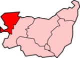
Forest Heath is a local government district
in Suffolk
, England
. Its council is based in Mildenhall
. Other towns in the district include Newmarket.
The district's name reflects the fact that it contains parts of both Thetford Forest
and the heathlands of Breckland
. The district was formed on 1 April 1974, under the Local Government Act 1972
, by a merger of the Newmarket urban district
and Mildenhall Rural District.
Forest Heath is the home to two of the largest USAF air bases in the UK, RAF Lakenheath
and RAF Mildenhall
, as well as the headquarters of British horse racing, Newmarket Racecourse
.
Non-metropolitan district
Non-metropolitan districts, or colloquially shire districts, are a type of local government district in England. As created, they are sub-divisions of non-metropolitan counties in a so-called "two-tier" arrangement...
in Suffolk
Suffolk
Suffolk is a non-metropolitan county of historic origin in East Anglia, England. It has borders with Norfolk to the north, Cambridgeshire to the west and Essex to the south. The North Sea lies to the east...
, England
England
England is a country that is part of the United Kingdom. It shares land borders with Scotland to the north and Wales to the west; the Irish Sea is to the north west, the Celtic Sea to the south west, with the North Sea to the east and the English Channel to the south separating it from continental...
. Its council is based in Mildenhall
Mildenhall, Suffolk
Mildenhall is a small market town and civil parish in Suffolk, England. It is run by Forest Heath District Council and has a population of 9,906 people. The town is near the A11 and is located north-west of county town, Ipswich. The large Royal Air Force base, RAF Mildenhall as well as RAF...
. Other towns in the district include Newmarket.
The district's name reflects the fact that it contains parts of both Thetford Forest
Thetford Forest
Thetford Forest is the largest lowland pine forest in Britain, Thetford Forest Park is located in a region straddling the north of Suffolk and the south of Norfolk in England...
and the heathlands of Breckland
Breckland
The Breckland as a landscape region is an unusual natural habitat of England. It comprises the gorse-covered sandy heath that exists in the north of the county of Suffolk and the south of Norfolk. An area of considerable interest for its unusual flora and fauna, it lies to the south east of another...
. The district was formed on 1 April 1974, under the Local Government Act 1972
Local Government Act 1972
The Local Government Act 1972 is an Act of Parliament in the United Kingdom that reformed local government in England and Wales on 1 April 1974....
, by a merger of the Newmarket urban district
Urban district
In the England, Wales and Ireland, an urban district was a type of local government district that covered an urbanised area. Urban districts had an elected Urban District Council , which shared local government responsibilities with a county council....
and Mildenhall Rural District.
Forest Heath is the home to two of the largest USAF air bases in the UK, RAF Lakenheath
RAF Lakenheath
RAF Lakenheath, is a Royal Air Force military airbase near Lakenheath in Suffolk, England. Although an RAF station, it hosts United States Air Force units and personnel...
and RAF Mildenhall
RAF Mildenhall
RAF Mildenhall is a Royal Air Force station located at Mildenhall in Suffolk, England. Despite its status as an RAF station, it primarily supports United States Air Force operations and is currently the home of the 100th Air Refueling Wing...
, as well as the headquarters of British horse racing, Newmarket Racecourse
Newmarket Racecourse
The town of Newmarket, in Suffolk, England, is the headquarters of British horseracing, home to the largest cluster of training yards in the country and many key horse racing organisations. Newmarket Racecourse has two courses - the Rowley Mile Course and the July Course. Both are wide, galloping...
.
Communities
The district contains three market towns and twenty civil parishes.Towns
- MildenhallMildenhall, SuffolkMildenhall is a small market town and civil parish in Suffolk, England. It is run by Forest Heath District Council and has a population of 9,906 people. The town is near the A11 and is located north-west of county town, Ipswich. The large Royal Air Force base, RAF Mildenhall as well as RAF...
- Newmarket
- BrandonBrandon, SuffolkBrandon is a small town and civil parish in the English county of Suffolk. It is in the Forest Heath local government district.Brandon is located in the Breckland area on the border of Suffolk with the adjoining county of Norfolk...
Civil parishes
- Barton MillsBarton MillsBarton Mills is a village and civil parish in the Forest Heath district of Suffolk, England. The village is on the south bank of the River Lark...
- Beck Row, Holywell Row and Kenny HillBeck Row, Holywell Row and Kenny HillThe villages of Beck Row, Holywell Row, Kenny Hill and Burnt Fen are a civil parish in the Forest Heath district of Suffolk, England. According to the 2001 census, it had a population of 4,048. The parish covers an area to the north of Mildenhall, including Beck Row, Holywell Row and Kenny Hill...
- CavenhamCavenhamCavenham is a civil parish in Suffolk, England, northwest of Bury St Edmunds. It is in the local government district of Forest Heath, and the electoral ward of Icini. The parish includes Cavenham Heath, a Site of Special Scientific Interest with a sand and gravel quarry. At the 2001 UK census,...
- DalhamDalhamDalham is a small settlement in Suffolk, England. It is west of the town of Bury St Edmunds.-Dalham Hall:In 1901 the estate of Dalham Hall was bought by Cecil Rhodes...
- ElvedenElvedenElveden is a village and civil parish in the Forest Heath district of Suffolk in eastern England. In 2005 it had a population of 270.The village is located on the A11 between Cambridge and Norwich and experiences a high volume of traffic...
- EriswellEriswellEriswell is a village and civil parish of Forest Heath in the English county of Suffolk.About forty scattered Archaeological finds have been made here, including Bronze Age battle axes, palstaves and rapiers....
- ExningExningExning is a village in Suffolk, England.It lies just off the A14 trunk road, roughly east-northeast of Cambridge, and south-south-east of Ely...
- FreckenhamFreckenhamFreckenham is a small rural village located in Suffolk, East Anglia, in the country of England.Geographically, it is relatively flat and has the River Kennet, a tributary of the River Lark locally known as the Lee Brook, cutting through the centre of the village...
- GazeleyGazeleyGazeley is a village and civil parish in the Forest Heath district of Suffolk in eastern England. In 2005 it had a population of 740. A house converted windmill survives in the village....
- HerringswellHerringswellHerringswell is a village and civil parish in the Forest Heath district of Suffolk in eastern England. In 2005 it had a population of 190.-External links:** Suffolk Churches...
- HighamHigham, Forest HeathHigham is a village and civil parish in the Forest Heath district of Suffolk in the east of England. Located midway between Bury St Edmunds and Newmarket, in 2005 its population was 140. Higham is split into three parts: Upper Green, Middle Green and Lower Green.Prior to the Beeching Axe, the...
- IcklinghamIcklinghamIcklingham is a village in Suffolk, England.It takes its name from an Iron Age tribe, the Iceni, who lived in the area and has the remains of a Roman settlement to the South...
- KentfordKentfordKentford is a village and civil parish in the Forest Heath district of Suffolk in eastern England. In 2005 it had a population of 420. Located just off the A14, close to the border with Cambridgeshire, it is served by nearby Kennett railway station....
- LakenheathLakenheathLakenheath is a village in Suffolk, England. It has around 8,200 residents, and is situated in the Forest Heath district of Suffolk, close to the county boundaries of both Norfolk and Cambridgeshire, and at the meeting point of the The Fens and the Breckland natural environments.Lakenheath is host...
- MoultonMoulton, SuffolkMoulton is a village in the Forest Heath district of Suffolk in England. In 2005, it had a population of 1090.The village pre-dates the Domesday book of 1086 and is older than the now larger town of Newmarket. It is famous for its fifteenth century packhorse bridge which spans the River Kennett....
- Red LodgeRed Lodge, SuffolkRed Lodge is a village situated in rural Suffolk between Mildenhall and Newmarket, and very close to the A11 and A14.-The town:Much development has taken place here over the last couple of years and it is still ongoing. This development consists of new homes from a variety of building companies and...
- Santon DownhamSanton DownhamSanton Downham is a village and civil parish in the Forest Heath district of Suffolk in eastern England. In 2005 it had a population of 240. The village is located within Thetford Forest on a meander of the River Little Ouse on the Norfolk-Suffolk border....
- TuddenhamTuddenhamTuddenham is a village and civil parish in the Forest Heath district of Suffolk in eastern England. In 2005 it had a population of 450.Between 1943 and 1963, RAF Tuddenham was a Royal Air Force airfield close to the village...
- WangfordWangfordWangford is a village in Suffolk, England, just off the A12 trunk road on the edge of the Henham Park estate just outside Southwold. .Wangford is connected to the rest of Suffolk by two main roads...
- WorlingtonWorlington, SuffolkWorlington is a village and civil parish in the English county of Suffolk and in the old Hundreds of Suffolk of Lackford.It is recorded in the Domesday Book as Wirilintona....