
Five Ponds Wilderness Area
Encyclopedia
Forest Preserve (New York)
New York's Forest Preserve is all the land owned by the state within the Adirondack and Catskill parks, managed by its Department of Environmental Conservation. These properties are required to be kept "forever wild" by Article 14 of the state constitution, and thus enjoy the highest degree of...
, is located in the towns of Fine
Fine, New York
Fine is a town in St. Lawrence County, New York, United States. The population was 1,622 at the 2000 census. The town is named after Judge John Fine, a businessman involved in settling the town....
and Clifton
Clifton, New York
Clifton is a town in St. Lawrence County, New York, United States. The population was 791 at the 2000 census. The town takes its name from a mining company.The Town of Clifton is in the south part of the county, within the Adirondack Park....
in St. Lawrence County
St. Lawrence County, New York
St. Lawrence County is a county located in the U.S. state of New York. As of the 2010 census, the population was 111,944. The county seat is Canton. The county is named for the Saint Lawrence River, which in turn was named for the Catholic saint on whose Feast day the river was discovered by...
, the town of Webb
Webb, New York
Webb is a the northernmost town in Herkimer County, New York, United States. The town is named after William Seward Webb, President of the Raquette Lake Transportation Company, the Fulton Chain Railway Company, Fulton Navigation Company, and the Mohawk and Malone Railway; his railroads were...
in Herkimer County
Herkimer County, New York
Herkimer County is a county located in the U.S. state of New York. It was created in 1791 north of the Mohawk River out of part of Montgomery County. As of the 2010 census, the population was 64,519. It is named after General Nicholas Herkimer, who died from battle wounds in 1777 after taking part...
and the town of Long Lake
Long Lake, New York
Long Lake is a town in Hamilton County, New York in the United States. The population was 852 at the 2000 census. The town is named for long Long Lake beside which it sits. The town is entirely within the Adirondack Park and is the most northerly town in the county. It is a summer tourism...
in Hamilton County
Hamilton County, New York
Hamilton County is a county located in the U.S. state of New York. It is named after Alexander Hamilton, the only member of the New York State delegation who signed the United States Constitution in 1787 and later the first United States Secretary of the Treasury. Its county seat is Lake Pleasant...
. It includes 1,064 acres (4.3 km2) of private inholdings, 99 bodies of water covering 1,964 acres (7.9 km2), 57.9 miles (93.2 km) of trails, and 14 lean-to
Lean-to
A lean-to is a term used to describe a roof with a single slope. The term also applies to a variety of structures that are built using a lean-to roof....
s.
Geography
The area is bounded on the north by Cranberry LakeCranberry Lake
Cranberry Lake is a lake on the Oswegatchie River in the Adirondack Park in New York in the United States. It is the third largest lake in the Adirondack Park Cranberry Lake is a lake on the Oswegatchie River in the Adirondack Park in New York in the United States. It is the third largest lake in...
, a portion of the Oswegatchie River
Oswegatchie River
The Oswegatchie River is a river in northern New York that flows north from the Adirondack Mountains to the Saint Lawrence River at the city of Ogdensburg. The river mouth was the site of a Jesuit mission, Fort de La Présentation, founded in 1749. Also a fur trading post, the village had 3,000...
, the road leading to lnlet
Inlet, New York
Inlet is a town in Hamilton County, New York in the United States of America. The population was 406 at the 2000 census. The name is derived from its location on an adjacent lake.The Town of Inlet is on the western edge of the county.- History :...
and private lands; on the east by the Colton
Colton, New York
Colton is a town in St. Lawrence County, New York, USA. The population was 1,453 at the 2000 census. The town, originally named Matildaville, is named after early settler Jesse Colton Higley....
town line and private lands in the vicinity of Gull Lake, a road leading to Gull Lake and the Remsen
Remsen, New York
Remsen, New York is the name of two locations in Oneida County, New York, USA:* Remsen , New York* Remsen , New York...
to Lake Placid
Lake Placid, New York
Lake Placid is a village in the Adirondack Mountains in Essex County, New York, United States. As of the 2000 census, the village had a population of 2,638....
railroad; on the south by Stillwater Reservoir; on the southwest by the Pepperbox Wilderness Area
Pepperbox Wilderness Area
The Pepperbox Wilderness Area, an Adirondack Park unit of the New York Forest Preserve, lies entirely within the town of Webb in Herkimer County. Stillwater Reservoir and the Beaver River Primitive Area form the southern boundary, while the north bank of the West Branch of the Oswegatchie River...
and on the west by private lands and the Aldrich Pond Wild Forest. In the vicinity of Young's Road the wild forest and wilderness boundary is the Streeter Lake snowmobile trail. Land south and east of this boundary will be classified wilderness upon acquisition of inholdings.
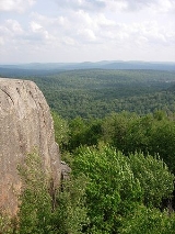
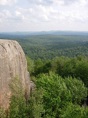
The terrain is low, rolling and interspersed with many small ponds. Swamp areas and small brooks are numerous. The forest cover varies from pole-size hardwoods in the sections that were heavily logged and burned more than forty years ago to virgin pine and spruce stands.
Forest
This is one of the few locations in the northeastern United StatesNortheastern United States
The Northeastern United States is a region of the United States as defined by the United States Census Bureau.-Composition:The region comprises nine states: the New England states of Connecticut, Maine, Massachusetts, New Hampshire, Rhode Island and Vermont; and the Mid-Atlantic states of New...
where stands of virgin timber
Old growth forest
An old-growth forest is a forest that has attained great age , and thereby exhibits unique ecological features. An old growth forest has also usually reached a climax community...
can be found. The Rich Lumber Company owned the land tract north of the St. Lawrence County line from 1903 to 1914. Although, some logging was done before 1903, the bulk of it occurred during this time period, when a railroad was put in to remove the large white pine logs. Part of Gatsby Creek was not logged and some of the tall white pines still stand along the State Trail. The East Branch Oswegatchie on the parts across from High Rock still has very tall white pines, across it on an adjacent tract of state land, that was acquired by New York State in a tax sale in 1884.
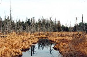
Several fires burned large areas south of Cranberry Lake
Cranberry Lake
Cranberry Lake is a lake on the Oswegatchie River in the Adirondack Park in New York in the United States. It is the third largest lake in the Adirondack Park Cranberry Lake is a lake on the Oswegatchie River in the Adirondack Park in New York in the United States. It is the third largest lake in...
. The blowdown
Blowdown
Blowdown may refer to:* Windthrow* Blowdown stack* Boiler blowdown* The sudden release of the contents of a nuclear power plant's reactor pressure vessel due to a materials failure, such as a crack in that vessel....
s of 1950 and 1995 did considerably more damage. South of the St. Lawrence County Line was owned by William Seward Webb
William Seward Webb
William Seward Webb, M.D. was a businessman, and Inspector General of the Vermont militia with the rank of Colonel. He was a founder and former President of the Sons of the American Revolution.-Biography:...
, and was never commercially lumbered; this area was sold to New York State in 1896. It holds the largest unlogged tract anywhere in the Eastern United States. It has been considerably damaged by both blowdowns, including over half of the esker at Five Ponds. The old growth pine and red spruce stand on the esker between Big Five, Little Five and Big Shallow, Little Shallow and Washbowl ponds is an example of this virgin timber.
Slightly south of the St. Lawrence
St. Lawrence County, New York
St. Lawrence County is a county located in the U.S. state of New York. As of the 2010 census, the population was 111,944. The county seat is Canton. The county is named for the Saint Lawrence River, which in turn was named for the Catholic saint on whose Feast day the river was discovered by...
-Herkimer
Herkimer County, New York
Herkimer County is a county located in the U.S. state of New York. It was created in 1791 north of the Mohawk River out of part of Montgomery County. As of the 2010 census, the population was 64,519. It is named after General Nicholas Herkimer, who died from battle wounds in 1777 after taking part...
-Hamilton
Hamilton County, New York
Hamilton County is a county located in the U.S. state of New York. It is named after Alexander Hamilton, the only member of the New York State delegation who signed the United States Constitution in 1787 and later the first United States Secretary of the Treasury. Its county seat is Lake Pleasant...
county marker stands what is (arguably) the largest virgin White Pine
Eastern White Pine
Pinus strobus, commonly known as the eastern white pine, is a large pine native to eastern North America, occurring from Newfoundland west to Minnesota and southeastern Manitoba, and south along the Appalachian Mountains to the northern edge of Georgia.It is occasionally known as simply white pine,...
in the Adirondacks. Recent tree surveys have found one white pine standing at 144 feet tall, however, none over 150 feet tall have been found there yet. The virgin pine stand at Pine Ridge near the East Branch of the Oswegatchie
Oswegatchie
Oswegatchie may refer to:In New York:*Oswegatchie, New York, a town in St. Lawrence County*Oswegatchie River, a tributary of the Saint Lawrence River*Oswegatchie , a native people of northern New York...
is another well known spot where examples of original growth timber may be seen. However, portions of the Pine Ridge
Pine Ridge
Pine Ridge may refer to:*Pine Ridge , of northwestern Nebraska and southwestern South Dakota*Pine Ridge Indian Reservation of southwestern South Dakota*Pine Ridge Campaign of the United States Army*Pine Ridge, Alabama...
stand were completely blown down in the 1950 hurricane. Most of the remainder of Pine Ridge
Pine Ridge
Pine Ridge may refer to:*Pine Ridge , of northwestern Nebraska and southwestern South Dakota*Pine Ridge Indian Reservation of southwestern South Dakota*Pine Ridge Campaign of the United States Army*Pine Ridge, Alabama...
was destroyed in the blowdown of 1995. The Adirondack Park Agency
Adirondack Park Agency
The Adirondack Park Agency was created in 1971 by New York Governor Nelson Rockefeller as a governmental agency that performs long-range planning for the future of the Adirondack Park. It oversees development plans of private land-owners as well as activities within the Adirondack Forest Preserve...
ruled to leave the downed timber untouched. Camp Johnny, a nearby rise of land and popular camping spot remained untouched. There is extreme blowdown in the Cat Mountain area and in the very remote and nearly untraveled Reilly Ponds section of the Five Ponds Wilderness Area.
Extremely difficult traveling conditions remain, where crisscrossing blowdown exists, with bushes and small trees and Witchobble grown up through. The Toad Pond area, on the very remote Robinson River area, has piles of Spruce blowdown. Not all areas have this extreme of blowdown— the southern portion of the Five Ponds Wilderness on the Red Horse Chain of Lakes (Salmon Lake, Witchopple Lake, and Clear Lake) has much of the forest in the valley areas still intact. Many white pines are standing on the Red Horse Creek, where the State Trail follows, forming a kind of double canopy in places. Very large Yellow Birch and Black Cherries can be found in places, near Clear Lake on Covey Pond Hill. Most of the large spruce around Mud Pond and the Clear Lake area have died off or have been blown down. One, on the northwest side of Clear Lake is over one hundred feet tall.
There are places that are seldom travelled, especially southeast of Sand Lake, west of Crooked Lake, and north of the Middle Branch of the Oswegatchie River. A large Carpet Spruce swamp exists in this area, intermixed with blowdown and rocks. The Middle Branch of the Oswegatchie, west of Willy's Lake and north of a private inholding at Bear Pond is not canoeable.
Recreation
Oswegatchie River
The Oswegatchie River is a river in northern New York that flows north from the Adirondack Mountains to the Saint Lawrence River at the city of Ogdensburg. The river mouth was the site of a Jesuit mission, Fort de La Présentation, founded in 1749. Also a fur trading post, the village had 3,000...
; Cat Mountain; Sand Lake; Wolf Pond; Big Deer Pond
Big Deer Pond
Big Deer Pond is located approximately 1.5 west of Lows Lake in the Five Ponds Wilderness Area and the Adirondacks "Bob Marshall Wilderness" area . It serves as a 1/2 mile water-portage between Lows Lake and the upper Oswegatchie River. The portage is a total of 3.5 miles through blowdown of...
; Nicks Pond; "The Plains," which are very similar in soil and cover type to that of the Moose River
Moose River (New York)
The Moose River is a mountain waterway which consists of three branches: the North Branch, the Middle Branch and the South Branch. The outlet of Big Moose Lake forms the North Branch in northern Herkimer County. The Middle Branch originates at the Fulton Chain Lakes in Old Forge. And the Southern...
Plains; and the numerous, clear, spring-fed ponds, most of which support brook trout.
Fishing
The East Branch of the Oswegatchie River was long considered the top brook troutBrook trout
The brook trout, Salvelinus fontinalis, is a species of fish in the salmon family of order Salmoniformes. In many parts of its range, it is known as the speckled trout or squaretail. A potamodromous population in Lake Superior are known as coaster trout or, simply, as coasters...
stream in the state, with catches of three to four pound brook trout common during the summer months. This distinction was lost when perch
Perch
Perch is a common name for fish of the genus Perca, freshwater gamefish belonging to the family Percidae. The perch, of which there are three species in different geographical areas, lend their name to a large order of vertebrates: the Perciformes, from the Greek perke meaning spotted, and the...
were apparently introduced accidentally or otherwise into Cranberry Lake several years ago, with adverse impacts to the brook trout population. At the present time, the area is popular with hunters and fishermen who frequent the interior ponds.
Canoeing
The East Branch of the Oswegatchie is a fine canoeingCanoeing
Canoeing is an outdoor activity that involves a special kind of canoe.Open canoes may be 'poled' , sailed, 'lined and tracked' or even 'gunnel-bobbed'....
stream and is used as such to reach interior wilderness points of interest. The river has received increasing use in recent years and care must be taken that such use does not result in resource degradation. There is a 3.5 mile canoe carry at approximately 18 miles upstream that leads the traveler to Lows Lake
Lows Lake
Lows Lake is a reservoir in the Adirondack Park in northeastern New York. It is located in the Five Ponds Wilderness Area, southwest of Tupper Lake. The lake is part of the Bog River Flow. While it is largely surrounded by New York State Forest Preserve, the northeast shore is privately held,...
via Big Deer Pond
Big Deer Pond
Big Deer Pond is located approximately 1.5 west of Lows Lake in the Five Ponds Wilderness Area and the Adirondacks "Bob Marshall Wilderness" area . It serves as a 1/2 mile water-portage between Lows Lake and the upper Oswegatchie River. The portage is a total of 3.5 miles through blowdown of...
.The existing lean-tos on the river will be phased out and ultimately replaced by primitive tent sites.There is also a canoe carry from Chair Rock Creeks' inlet on Cranberry Lake to Grass Pond on Lows Lake
Public access
The Five Ponds area is accessible to the public from the north and also from the south if one has a boat or canoe, from the east from the vicinity of Lake LilaLake Lila
Lake Lila is a 1,400 acre Lake in the William C. Whitney Wilderness Area, in the town of Long Lake, in the west-central portion of the Adirondack Park....
in the William C. Whitney Wilderness Area
William C. Whitney Wilderness Area
The William C. Whitney Wilderness Area, an Adirondack Park unit of New York's Forest Preserve, is located in the town of Long Lake, Hamilton County...
and along the Remsen to Lake Placid railroad. The area can also be reached from the southwest via the Raven Lake primitive corridor, and from the east, by boat or canoe, via the Bog River
Bog River
The Bog River, also called the Bog River Flow is a river that originates near the sources of the Oswegatchie River, in Hamilton County, New York in the Adirondacks, and flows through Lows Lake and Hitchens Pond, ending at the Bog River Falls at the entrance to Tupper Lake. For much of its...
/Low's Lake tract. The western boundary in Herkimer County is accessible from the Bear Pond Road in the Aldrich Pond Wild Forest.