
Five Creek
Encyclopedia
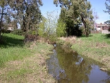
Five Creek is a westward flowing stream that rises in the city of Rohnert Park, California
, United States
and discharges to the Laguna de Santa Rosa
. The creek is channelized as it flows through the city and runs in an artificially rectilinear fashion. Considered waters of the United States as a jurisdictional matter, Five Creek has potential habitat for the California red-legged frog
and the Western pond turtle
.
The name probably originated as a misreading of "Fire Creek," the name found on older maps.
topographic map shows an unnamed westward-flowing creek circling north of Wilfred like Five Creek does today. At that time, the creek's headwaters lay in the Sonoma Mountains
just north of Crane Creek
. The Geographic Names Information System
(GNIS) gives Five Creek's source coordinates as 38.3552778°N 122.6894444°W, currently a channel on the east edge of Eagle Park. However, satellite photos show this channel connecting to Hinebaugh Creek
north of San Mateo Court. A recent topographic map shows Five Creek emerging near the corner of Golf Course Drive and Country Club Drive, its former headwaters having been diverted to Crane Creek.
From Golf Course Drive, Five Creek flows northwest, paralleling Country Club Drive to Fairway Drive. It crosses the golf course, emerging near the end of Fauna Avenue. North of the city limits, it turns abruptly westward and flows under U.S. Route 101
at the Santa Rosa Avenue interchange. West of U.S. Route 101, the channel turns to the southwest, crossing under Millbrae Avenue, Whistler Avenue, Wilfred Avenue, and Rohnert Park Expressway before entering the Laguna de Santa Rosa
just east of Stony Point Road.
The GNIS gives the mouth coordinates of Five Creek as 38.3499144°N 122.7322104°W. However, satellite images and United States Geological Survey
topographic maps, show Hinebaugh Creek entering the Laguna at those coordinates. The Five Creek confluence lies about 0.5 mi (0.80467 km) further west.
Rohnert Park, California
Rohnert Park is a city in Sonoma County, California, United States, located approximately north of San Francisco. The population at the 2010 United States Census was 40,971. It is an early planned city, modeled directly after Levittown, New York and Levittown, Pennsylvania. Rohnert Park is the...
, United States
United States
The United States of America is a federal constitutional republic comprising fifty states and a federal district...
and discharges to the Laguna de Santa Rosa
Laguna de Santa Rosa
The Laguna de Santa Rosa is a long wetland complex that drains a 254-square mile watershed encompassing most of the Santa Rosa Plain in Sonoma County, California, USA.-Description:...
. The creek is channelized as it flows through the city and runs in an artificially rectilinear fashion. Considered waters of the United States as a jurisdictional matter, Five Creek has potential habitat for the California red-legged frog
California Red-legged Frog
The California red-legged frog, Rana draytonii, is a moderate to large species of frog. It is known under the scientific name Rana draytonii, after being long included with the northern red-legged frog The California red-legged frog, Rana draytonii, is a moderate to large (4.4–14 cm) species...
and the Western pond turtle
Western pond turtle
The western pond turtle , or Pacific pond turtle is a small to medium-sized turtle growing to approximately 20 cm in carapace length. It is limited to the west coast of the United States of America and Mexico, ranging from western Washington state to northern Baja California...
.
The name probably originated as a misreading of "Fire Creek," the name found on older maps.
Course
The route of Five Creek has been obscured by the development of Rohnert Park. A 1916 United States Geological SurveyUnited States Geological Survey
The United States Geological Survey is a scientific agency of the United States government. The scientists of the USGS study the landscape of the United States, its natural resources, and the natural hazards that threaten it. The organization has four major science disciplines, concerning biology,...
topographic map shows an unnamed westward-flowing creek circling north of Wilfred like Five Creek does today. At that time, the creek's headwaters lay in the Sonoma Mountains
Sonoma Mountains
The Sonoma Mountains are a northwest-southeast trending formation of California Coast Ranges in Sonoma County, California, USA. The range is approximately fourteen miles long and separates the Sonoma Creek watershed from the Petaluma River and Tolay Creek watersheds...
just north of Crane Creek
Crane Creek (California)
Crane Creek is a stream in Sonoma County, California, USA which rises in the northern Sonoma Mountains. This watercourse flows through Crane Canyon and the Crane Creek Regional Park situated on the northwestern flank of Sonoma Mountain...
. The Geographic Names Information System
Geographic Names Information System
The Geographic Names Information System is a database that contains name and locative information about more than two million physical and cultural features located throughout the United States of America and its territories. It is a type of gazetteer...
(GNIS) gives Five Creek's source coordinates as 38.3552778°N 122.6894444°W, currently a channel on the east edge of Eagle Park. However, satellite photos show this channel connecting to Hinebaugh Creek
Hinebaugh Creek
Hinebaugh Creek is a westward-flowing stream in western Sonoma County within the Laguna de Santa Rosa watershed. As this watercourse proceeds westerly through the city of Rohnert Park, it has largely been channelized and courses in an artificially straight alignment...
north of San Mateo Court. A recent topographic map shows Five Creek emerging near the corner of Golf Course Drive and Country Club Drive, its former headwaters having been diverted to Crane Creek.
From Golf Course Drive, Five Creek flows northwest, paralleling Country Club Drive to Fairway Drive. It crosses the golf course, emerging near the end of Fauna Avenue. North of the city limits, it turns abruptly westward and flows under U.S. Route 101
U.S. Route 101
U.S. Route 101, or U.S. Highway 101, is an important north–south U.S. highway that runs through the states of California, Oregon, and Washington, on the West Coast of the United States...
at the Santa Rosa Avenue interchange. West of U.S. Route 101, the channel turns to the southwest, crossing under Millbrae Avenue, Whistler Avenue, Wilfred Avenue, and Rohnert Park Expressway before entering the Laguna de Santa Rosa
Laguna de Santa Rosa
The Laguna de Santa Rosa is a long wetland complex that drains a 254-square mile watershed encompassing most of the Santa Rosa Plain in Sonoma County, California, USA.-Description:...
just east of Stony Point Road.
The GNIS gives the mouth coordinates of Five Creek as 38.3499144°N 122.7322104°W. However, satellite images and United States Geological Survey
United States Geological Survey
The United States Geological Survey is a scientific agency of the United States government. The scientists of the USGS study the landscape of the United States, its natural resources, and the natural hazards that threaten it. The organization has four major science disciplines, concerning biology,...
topographic maps, show Hinebaugh Creek entering the Laguna at those coordinates. The Five Creek confluence lies about 0.5 mi (0.80467 km) further west.