

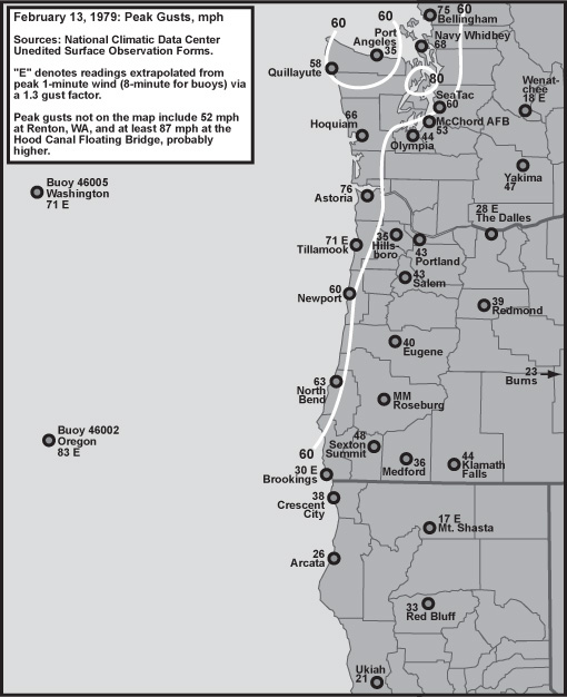
February 13, 1979 Windstorm
Encyclopedia
Cyclone
In meteorology, a cyclone is an area of closed, circular fluid motion rotating in the same direction as the Earth. This is usually characterized by inward spiraling winds that rotate anticlockwise in the Northern Hemisphere and clockwise in the Southern Hemisphere of the Earth. Most large-scale...
moved across southern Vancouver Island
Vancouver Island
Vancouver Island is a large island in British Columbia, Canada. It is one of several North American locations named after George Vancouver, the British Royal Navy officer who explored the Pacific Northwest coast of North America between 1791 and 1794...
, British Columbia
British Columbia
British Columbia is the westernmost of Canada's provinces and is known for its natural beauty, as reflected in its Latin motto, Splendor sine occasu . Its name was chosen by Queen Victoria in 1858...
. South of the low center, a strong atmospheric pressure gradient was carried across Washington, with associated high winds. With a cold airflow moving toward the northeast interacting with the high terrain of the Olympic Mountains
Olympic Mountains
The Olympic Mountains is a mountain range on the Olympic Peninsula of western Washington in the United States. The mountains, part of the Pacific Coast Ranges, are not especially high - Mount Olympus is the highest at - but the western slopes of the Olympics rise directly out of the Pacific...
, a lee low developed east of the Olympics. The mesoscale
Mesoscale meteorology
Mesoscale meteorology is the study of weather systems smaller than synoptic scale systems but larger than microscale and storm-scale cumulus systems. Horizontal dimensions generally range from around 5 kilometers to several hundred kilometers...
low caused a particularly intense pressure gradient to develop across the Kitsap Peninsula
Kitsap Peninsula
The Kitsap Peninsula is an arm of land that is part of the larger Olympic Peninsula in Washington state that lies west of Seattle across Puget Sound. Hood Canal separates Kitsap Peninsula from the rest of the Olympic Peninsula...
region.
Wind velocity
At 6 mbar over 8 miles, the geostrophicGeostrophic
A geostrophic current is an oceanic flow in which the pressure gradient force is balanced by the Coriolis force. The direction of geostrophic flow is parallel to the isobars, with the high pressure to the right of the flow in the Northern Hemisphere, and the high pressure to the left in the...
wind potential easily exceeded 200 knots (which roughly translates to about 100 knots in ageostrophic flow over the Earth's rough surface, or 115 mph). As reported by the crew of the Hood Canal Bridge
Hood Canal Bridge
The Hood Canal Bridge is a floating bridge located in the U.S. state of Washington that carries Washington State Route 104 across Hood Canal and connects the Olympic and Kitsap Peninsulas. At long, The Hood Canal Bridge (officially William A. Bugge Bridge) is a floating bridge located in the U.S....
, average winds reached at least 80 mph out of the south, with gusts into the triple digits. These wind velocities were cross-checked on two different anemometers at the bridge control tower.
Damage
Extensive damage to trees on surrounding private timberland also corroborate the extreme intensity of this tempest. The pressure of wind and wave on the Hood Canal BridgeHood Canal Bridge
The Hood Canal Bridge is a floating bridge located in the U.S. state of Washington that carries Washington State Route 104 across Hood Canal and connects the Olympic and Kitsap Peninsulas. At long, The Hood Canal Bridge (officially William A. Bugge Bridge) is a floating bridge located in the U.S....
stressed the structure enough to cause catastrophic failure. It is suspected that a severe list in the bridge exposed pontoon access hatches to the waves, which subsequently tore the covers loose and allowed water to enter the flotation devices, causing sections to sink. It took nearly three years and over $140 million U.S. to rebuild the lost bridge.
Further reading
- Richard J. Reed, "Destructive Wind Caused by an Orographically Induced Mesoscale Cyclone," in Monthly Weather Review, Vol. 61, No. 11, November 1980.