

Fall River Government Center
Encyclopedia
Fall River, Massachusetts
Fall River is a city in Bristol County, Massachusetts, in the United States. It is located about south of Boston, southeast of Providence, Rhode Island, and west of New Bedford and south of Taunton. The city's population was 88,857 during the 2010 census, making it the tenth largest city in...
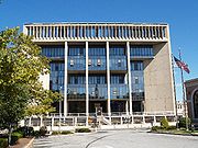
, United States. Located at One Government Center, and constructed directly over Interstate 195
Interstate 195 (Rhode Island-Massachusetts)
Interstate 195 is an Interstate Highway running a combined 40.1 miles in the U.S. states of Massachusetts and Rhode Island. It travels from a junction with Interstate 95 in Providence, Rhode Island east to a junction with Interstate 495 and Route 25 in Wareham, Massachusetts...
, it was the first public building built over a Federal interstate highway. It replaced the city's historic 19th century city hall which had been demolished in the early 1960s as part of the construction of Interstate 195
Interstate 195 (Rhode Island-Massachusetts)
Interstate 195 is an Interstate Highway running a combined 40.1 miles in the U.S. states of Massachusetts and Rhode Island. It travels from a junction with Interstate 95 in Providence, Rhode Island east to a junction with Interstate 495 and Route 25 in Wareham, Massachusetts...
, which cuts through the center of the city's downtown area. Delayed and plagued by problems during construction, the new city hall opened in 1976. In 2008, the building and site underwent a multi-million dollar exterior renovation.
Location
The current Fall River Government Center is located at the historic "crossroads" of the city, at the intersection of Central Street (Bedford Street) and Main Street. Fall River's first town hall was destroyed in the first great downtown fire of 1843, which destroyed over 200 buildings in the center of town.Old city hall
The city's historic 19th century city hall was demolished in the early 1960s for construction of Interstate 195Interstate 195 (Rhode Island-Massachusetts)
Interstate 195 is an Interstate Highway running a combined 40.1 miles in the U.S. states of Massachusetts and Rhode Island. It travels from a junction with Interstate 95 in Providence, Rhode Island east to a junction with Interstate 495 and Route 25 in Wareham, Massachusetts...
, which cut through the heart of downtown Fall River
Fall River
-Cities and towns:In Canada:*Fall River, Nova ScotiaIn the United States:*Fall River, Kansas*Fall River, Massachusetts, the largest city with this name*Fall River, Tennessee*Fall River, Wisconsin*Fall River County, South Dakota-Rivers:In Canada:...
. It was a time of so-called "urban renewal" in the city after the tough years since the collapse of the city's textile industry in the 1920s and 1930s. Several other 19th and early 20th century buildings were also demolished as part of the new highway construction. The old city hall, which had survived two fires was constructed directly over the Quequechan River
Quequechan River
The Quequechan River , is a river in Fall River, Massachusetts that flows in a northwesterly direction from the South Watuppa Pond to the Taunton River. The word Quequechan means "falling water" in Wampanoag, hence the city's name....
, the source of power for the early textile mills. As part of the highway project, the river was diverted into an underground culvert which parallels the highway, along the south side of the current city hall. Two granite columns from the front of the old city hall are located across from the current building, along Sullivan Drive, next to the Academy Building.
Current building
The new Government Center (city hall), constructed of reinforced concrete and glass, in the popular Brutalist style of the 1960s and 1970s opened in 1976, after years of construction delays and quality control problems. The main buildings occupies a space further east than the original city hall, which was closer to South Main Street. A wing of the current building, which contains the city council chambers is located at the west end of the site, closer to South Main Street. A plaza was created north of the new city hall, between the adjacent United States Post Office. The original scheme for the new city hall included a parking garage, that was later eliminated from the design.The main building is a concrete cube, approximately 144 feet (44 m) square, with a smaller glass-enclosed cube forming the middle floors. The building is set atop an elevated "basement" containing mechanical and storage areas constructed atop the steel platform which spans the highway. The platform also includes South Main Street to the west and Second Street to the east, creating a 900 foot (274 m) long tunnel.
Recent history
In March 1999, concrete slabs forming the ceiling of the tunnel beneath Government Center fell onto the westbound lanes of Interstate 195Interstate 195 (Rhode Island-Massachusetts)
Interstate 195 is an Interstate Highway running a combined 40.1 miles in the U.S. states of Massachusetts and Rhode Island. It travels from a junction with Interstate 95 in Providence, Rhode Island east to a junction with Interstate 495 and Route 25 in Wareham, Massachusetts...
, causing a six-vehicle accident in which a minivan overturned. Amazingly nobody was killed in the incident which was later determine to have resulted from corrosion of the support brackets which held the concrete slabs. As a result, state highway officials ordered the immediate removal of all the concrete ceiling slabs beneath Government Center. This however, left the underside of the building vulnerable to fire, in the event of an accident within the tunnel.
As a result of the fire protection panels being removed from beneath Government Center, it was decided by state and local officials that all trucks carrying hazardous cargo (gasoline, oil, etc.) could not pass under the building along Interstate 195. For several years, these vehicles were detoured through the city streets around Government Center. In May 2008, with the replacement of the concrete panels complete, this restriction was removed.
See also
- Fall River, MassachusettsFall River, MassachusettsFall River is a city in Bristol County, Massachusetts, in the United States. It is located about south of Boston, southeast of Providence, Rhode Island, and west of New Bedford and south of Taunton. The city's population was 88,857 during the 2010 census, making it the tenth largest city in...
- History of Fall River, MassachusettsHistory of Fall River, MassachusettsFor much of its history, the city of Fall River, Massachusetts has been defined by the rise and fall of its cotton textile industry. From its beginnings as a rural outpost of the Plymouth Colony, the city grew to become the largest textile producing center in the United States during the 19th...
- Interstate 195Interstate 195 (Rhode Island-Massachusetts)Interstate 195 is an Interstate Highway running a combined 40.1 miles in the U.S. states of Massachusetts and Rhode Island. It travels from a junction with Interstate 95 in Providence, Rhode Island east to a junction with Interstate 495 and Route 25 in Wareham, Massachusetts...