

Eureka Valley Sand Dunes
Encyclopedia
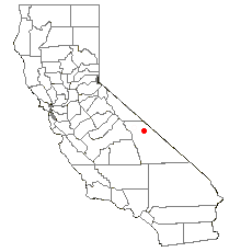
Eureka Valley, Inyo County
Eureka Valley is located in Inyo County, in eastern California in the southwestern United States. It is approximately 28 miles long and up to 10 miles wide, with elevations varying from 2870 feet up to 8456 feet...
, in northern Inyo County
Inyo County, California
-National protected areas:* Death Valley National Park * Inyo National Forest * Manzanar National Historic Site-Major highways:* U.S. Route 6* U.S. Route 395* State Route 127* State Route 136* State Route 168* State Route 178...
in eastern California
California
California is a state located on the West Coast of the United States. It is by far the most populous U.S. state, and the third-largest by land area...
, in the southwestern United States
United States
The United States of America is a federal constitutional republic comprising fifty states and a federal district...
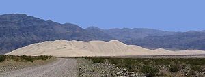
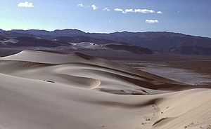
. Although covering an area of only 3 square miles (8 km²), the dunes rise approximately 680 feet (207 m) above the surrounding valley floor, making them one of the highest dune fields in North America.
Big Pine, California
Big Pine is a census-designated place in Inyo County, California, United States. Big Pine is located south-southeast of Bishop, at an elevation of 3990 feet . The population was 1,756 at the 2010 census, up from 1,350 at the 2000 census...
to the Grapevine section of Death Valley
Death Valley
Death Valley is a desert valley located in Eastern California. Situated within the Mojave Desert, it features the lowest, driest, and hottest locations in North America. Badwater, a basin located in Death Valley, is the specific location of the lowest elevation in North America at 282 feet below...
), the dunes became part of the Death Valley National Park
Death Valley National Park
Death Valley National Park is a national park in the U.S. states of California and Nevada located east of the Sierra Nevada in the arid Great Basin of the United States. The park protects the northwest corner of the Mojave Desert and contains a diverse desert environment of salt-flats, sand dunes,...
as part of its expansion in 1994. Foot travel in the dunes is permitted, but vehicle access is prohibited. A primitive campground is located at the north end of the dune field.
The Eureka Dunes are the home of several unique (and protected) plant species. The Eureka Dune Grass (Swallenia alexandrae), the Eureka Evening Primrose
Oenothera californica
Oenothera californica is a species of flowering plant in the evening primrose family known by the common name California evening primrose...
(Oenothera californica eurekensis), and the Shining Locoweed
Astragalus lentiginosus
Astragalus lentiginosus is a species of legume known by the common names spotted locoweed and freckled milkvetch. It is native to western North America where it grows in many habitat types. There are a great number of wild varieties of this species, and they vary in appearance...
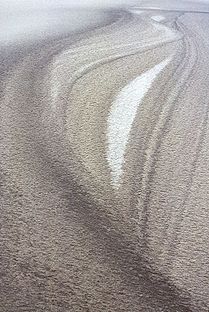
(Astragalus lentiginosus micans) are only found in this area. Visitors to the dunes may also experience other unique aspects of these dunes. The Eureka Dunes are known as singing dunes because in dry weather, slipping of the sand can produce
Singing sand
Singing sand, whistling sand or barking sand is sand that produces sound. The sound emission may be caused by wind passing over dunes or by walking on the sand.Certain conditions have to come together to create singing sand:...
a 'booming' sound. Conversely, in wet weather, patterns can be seen in the sand that reveals its diverse sources, and the complex Aeolian process by which these dunes are formed (and re-formed).
Sand dunes also exist in Death Valley near Stovepipe Wells
Stovepipe Wells, California
Stovepipe Wells is a small way-station in the northern part of Death Valley, in unincorporated Inyo County, California.-Geography and names:Stovepipe Wells is located at and is US Geological Survey feature ID 235564. It is entirely inside Death Valley National Park and along State Route 190 at...
.