

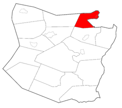
Esperance (town), New York
Encyclopedia
Town
A town is a human settlement larger than a village but smaller than a city. The size a settlement must be in order to be called a "town" varies considerably in different parts of the world, so that, for example, many American "small towns" seem to British people to be no more than villages, while...
in Schoharie County
Schoharie County, New York
As of the census of 2000, there were 31,582 people, 11,991 households and 8,177 families residing in the county. The population density was 51 people per square mile . There were 15,915 housing units at an average density of 26 per square mile...
, New York
New York
New York is a state in the Northeastern region of the United States. It is the nation's third most populous state. New York is bordered by New Jersey and Pennsylvania to the south, and by Connecticut, Massachusetts and Vermont to the east...
, USA. The population was 2,043 at the 2000 census. The town was given the name of the principal village, which was named for "hope" in French
French language
French is a Romance language spoken as a first language in France, the Romandy region in Switzerland, Wallonia and Brussels in Belgium, Monaco, the regions of Quebec and Acadia in Canada, and by various communities elsewhere. Second-language speakers of French are distributed throughout many parts...
.
The Town of Esperance contains a village called Esperance
Esperance (village), New York
Esperance is a village in Schoharie County, New York, USA. The population was 380 at the 2000 census. The village was given the French name for "hope."The Village of Esperance is in eastern part of the Town of Esperance...
. The town is in the northeast part of Schoharie County and is west of Schenectady
Schenectady, New York
Schenectady is a city in Schenectady County, New York, United States, of which it is the county seat. As of the 2010 census, the city had a population of 66,135...
.
History
The town was first settled around 1739.Esperance village was incorporated in 1819 and rechartered in 1835, before the Town of Esperance was established.
The town was formed in 1846 from the Town of Schoharie
Schoharie (town), New York
Schoharie is a town in Schoharie County, New York. The population was 3,299 at the 2000 census. The village is named after a native word for driftwood.The Town of Schoharie has a village, also called Schoharie...
.
Geography
According to the United States Census BureauUnited States Census Bureau
The United States Census Bureau is the government agency that is responsible for the United States Census. It also gathers other national demographic and economic data...
, the town has a total area of 20.0 square miles (51.9 km²), of which, 19.6 square miles (50.7 km²) of it is land and 0.5 square miles (1.2 km²) of it (2.29%) is water.
The east town line, partly marked by the Schoharie Creek
Schoharie Creek
Schoharie Creek in New York, USA flows north from the foot of Indian Head Mountain in the Catskill Mountains through the Schoharie Valley to the Mohawk River. It is twice impounded north of Prattsville to create New York City's Schoharie Reservoir and the Blenheim-Gilboa Power Project.Two notable...
, is the border of Schenectady County
Schenectady County, New York
Schenectady County is a county located in the U.S. state of New York. As of the 2010 census, the population was 154,727. It is part of the Albany-Schenectady-Troy Metropolitan Statistical Area. The county seat is Schenectady. The name is from a Mohawk Indian word meaning "on the other side of the...
, and the north town line is the border of Montgomery County
Montgomery County, New York
As of the census of 2000, there were 49,708 people, 20,038 households, and 13,104 families residing in the county. The population density was 123 people per square mile . There were 22,522 housing units at an average density of 56 per square mile...
. Cripplebush Creek flows into Schoharie Creek south of Sloansville.
US Route 20 is an east-west highway through the town. New York State Route 30A
New York State Route 30A
New York State Route 30A is a state highway in the Capital District of New York in the United States. It serves as a westerly alternate route of NY 30 from near the Schoharie County village of Schoharie to the Fulton County hamlet of Riceville, south of the village of Mayfield...
is a north-south highway, intersecting US-20 at Sloansville. New York State Route 162
New York State Route 162
New York State Route 162 is a state highway in eastern New York, United States. It runs from the hamlet of Sloansville within the town of Esperance, Schoharie County to the hamlet of Sprakers within the town of Root, Montgomery County, west of the village of Canajoharie...
intersects NY-30A near Dwelly Corners.
Demographics
As of the censusCensus
A census is the procedure of systematically acquiring and recording information about the members of a given population. It is a regularly occurring and official count of a particular population. The term is used mostly in connection with national population and housing censuses; other common...
of 2000, there were 2,043 people, 776 households, and 571 families residing in the town. The population density
Population density
Population density is a measurement of population per unit area or unit volume. It is frequently applied to living organisms, and particularly to humans...
was 104.3 people per square mile (40.3/km²). There were 856 housing units at an average density of 43.7 per square mile (16.9/km²). The racial makeup of the town was 98.14% White, 0.34% Black or African American
Race (United States Census)
Race and ethnicity in the United States Census, as defined by the Federal Office of Management and Budget and the United States Census Bureau, are self-identification data items in which residents choose the race or races with which they most closely identify, and indicate whether or not they are...
, 0.15% Native American, 0.39% Asian, 0.05% from other races
Race (United States Census)
Race and ethnicity in the United States Census, as defined by the Federal Office of Management and Budget and the United States Census Bureau, are self-identification data items in which residents choose the race or races with which they most closely identify, and indicate whether or not they are...
, and 0.93% from two or more races. Hispanic or Latino of any race were 0.83% of the population.
There were 776 households out of which 35.2% had children under the age of 18 living with them, 59.1% were married couples
Marriage
Marriage is a social union or legal contract between people that creates kinship. It is an institution in which interpersonal relationships, usually intimate and sexual, are acknowledged in a variety of ways, depending on the culture or subculture in which it is found...
living together, 9.5% had a female householder with no husband present, and 26.3% were non-families. 20.2% of all households were made up of individuals and 7.7% had someone living alone who was 65 years of age or older. The average household size was 2.63 and the average family size was 3.01.
In the town the population was spread out with 26.3% under the age of 18, 7.8% from 18 to 24, 29.3% from 25 to 44, 25.0% from 45 to 64, and 11.6% who were 65 years of age or older. The median age was 38 years. For every 100 females there were 105.9 males. For every 100 females age 18 and over, there were 103.2 males.
The median income for a household in the town was $42,930, and the median income for a family was $46,940. Males had a median income of $32,331 versus $24,115 for females. The per capita income
Per capita income
Per capita income or income per person is a measure of mean income within an economic aggregate, such as a country or city. It is calculated by taking a measure of all sources of income in the aggregate and dividing it by the total population...
for the town was $17,574. About 4.8% of families and 7.4% of the population were below the poverty line, including 7.0% of those under age 18 and 8.0% of those age 65 or over.
Communities and locations in the Town of Esperance
- Central Bridge – A hamletHamlet (place)A hamlet is usually a rural settlement which is too small to be considered a village, though sometimes the word is used for a different sort of community. Historically, when a hamlet became large enough to justify building a church, it was then classified as a village...
at the south town line on NY-30A. - Dwelly Corners – A hamlet north of Sloansville on County Road 35.
- EsperanceEsperance (village), New YorkEsperance is a village in Schoharie County, New York, USA. The population was 380 at the 2000 census. The village was given the French name for "hope."The Village of Esperance is in eastern part of the Town of Esperance...
– The Village of Esperance is at the east town line on US-20 by the Schoharie Creek. - Sloansville – A hamlet west of Esperance village on US-20 at NY-30A. It was settled around the year 1756.
- Rockwell Corners – A location at the north town line on County Road 44.
- Schoharie Junction – A hamlet in the south part of the town on County Road 70.
- Burtonsville – A location in the northeast part of the town flanking the Schoharie CreekSchoharie CreekSchoharie Creek in New York, USA flows north from the foot of Indian Head Mountain in the Catskill Mountains through the Schoharie Valley to the Mohawk River. It is twice impounded north of Prattsville to create New York City's Schoharie Reservoir and the Blenheim-Gilboa Power Project.Two notable...
.
Points of interest
- George Landis ArboretumGeorge Landis ArboretumThe George Landis Arboretum consists of , of which are devoted to noteworthy collections and gardens overlooking the Schoharie Valley near Esperance, New York, USA. It contains approximately 2,000 labeled specimens, with plantings of trees, shrubs, and herbaceous perennials from around the world....
- George Westinghouse, Jr., Birthplace and Boyhood HomeGeorge Westinghouse, Jr., Birthplace and Boyhood HomeGeorge Westinghouse, Jr., Birthplace and Boyhood Home is a historic home located at Central Bridge in Schoharie County, New York. The property includes two 19th-century residences, two small barns, a well house and privy, as well as the site of a combined blacksmith shop and threshing machine works...
is in the hamlet of Central Bridge - Esperance Museum & Historical Society
- Old Village Ice Cream Parlor
- Hope Wildlife Gallery
- Frank Walker's Livestock Sales