

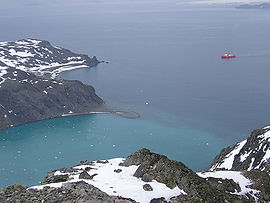
Española Cove
Encyclopedia
South Bay, Livingston Island
South Bay is a wide bay indenting for the south coast of Livingston Island in the South Shetland Islands, Antarctica. The bay is lying northwest of False Bay and east of Walker Bay, and is entered between Hannah Point and Miers Bluff....
in the South Shetland Islands
South Shetland Islands
The South Shetland Islands are a group of Antarctic islands, lying about north of the Antarctic Peninsula, with a total area of . By the Antarctic Treaty of 1959, the Islands' sovereignty is neither recognized nor disputed by the signatories and they are free for use by any signatory for...
, Antarctica. Entered between Ballester Point
Ballester Point
Ballester Point is a point forming the south side of the entrance to Johnsons Dock and the northeast side of the entrance to Española Cove in Hurd Peninsula, Livingston Island in the South Shetland Islands, Antarctica...
and Polish Bluff
Polish Bluff
Polish Bluff is a point forming the southwest side of the entrance to Española Cove and the northeast side of the entrance to Argentina Cove in Hurd Peninsula, Livingston Island in the South Shetland Islands, Antarctica...
. The cove is used for the transfer of people and cargo to the Spanish
Spain
Spain , officially the Kingdom of Spain languages]] under the European Charter for Regional or Minority Languages. In each of these, Spain's official name is as follows:;;;;;;), is a country and member state of the European Union located in southwestern Europe on the Iberian Peninsula...
base Juan Carlos I situated at its head. The area was frequented by early 19th century sealers
Seal hunting
Seal hunting, or sealing, is the personal or commercial hunting of seals. The hunt is currently practiced in five countries: Canada, where most of the world's seal hunting takes place, Namibia, the Danish region of Greenland, Norway and Russia...
operating from nearby Johnsons Dock
Johnsons Dock
Johnsons Dock is a sheltered 500 m wide cove indenting for 900 m the southeast coast of South Bay, Livingston Island in the South Shetland Islands, Antarctica. Entered north of Ballester Point. Surmounted by Charrúa Ridge on the northeast...
.
The feature was mapped and named by the Spanish Antarctic Expedition in 1991.
Location
The cove's midpoint is located at 62°39′35.2"S 60°22′59.8"W which is 1.83 km south-southwest of Hespérides PointHespérides Point
Hespérides Point is a rocky point of land projecting into South Bay north-northwest of Johnsons Dock, Livingston Island in the South Shetland Islands, Antarctica and forming the southwest side of the entrance to Emona Anchorage. Surmounted by Hesperides Hill...
and 7.25 km north-northeast of Miers Bluff
Miers Bluff
Miers Bluff is the point forming the southwest extremity of Hurd Peninsula, the southeast side of the entrance to South Bay and the northwest side of the entrance to False Bay in the South Shetland Islands, Antarctica....
(British mapping in and 1968, detailed Spanish mapping in 1991, and Bulgarian mapping in 1996, 2005 and 2009).
Maps
- Isla Livingston: Península Hurd. Mapa topográfico de escala 1:25 000. Madrid: Servicio Geográfico del Ejército, 1991.
- L.L. Ivanov. Livingston Island: Central-Eastern Region. Scale 1:25000 topographic map. Sofia: Antarctic Place-names Commission of Bulgaria, 1996.
- L.L. Ivanov et al. Antarctica: Livingston Island and Greenwich Island, South Shetland Islands. Scale 1:100000 topographic map. Sofia: Antarctic Place-names Commission of Bulgaria, 2005.
- L.L. Ivanov. Antarctica: Livingston Island and Greenwich, Robert, Snow and Smith Islands. Scale 1:120000 topographic map. Troyan: Manfred Wörner Foundation, 2009. ISBN 978-954-92032-6-4