

Ephraim Bluff
Encyclopedia
Breznik Heights
Breznik Heights rises to over 600 m in the southeast part of Greenwich Island. They extend 12 km between Santa Cruz Point in the north east and the base of the moraine spit at the mouth of Yankee Harbour in the southwest...
, Greenwich Island
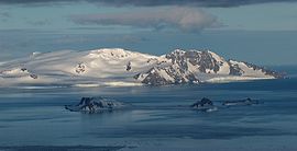
Greenwich Island (South Shetland Islands)
Greenwich Island is an island long and from wide, lying between Robert Island and Livingston Island in the South Shetland Islands. Surface area...
in the South Shetland Islands
South Shetland Islands
The South Shetland Islands are a group of Antarctic islands, lying about north of the Antarctic Peninsula, with a total area of . By the Antarctic Treaty of 1959, the Islands' sovereignty is neither recognized nor disputed by the signatories and they are free for use by any signatory for...
, Antarctica. The bluff is linked to Razgrad Peak
Razgrad Peak
Razgrad Peak is an ice-covered peak rising to 550 m in Breznik Heights, Greenwich Island, Antarctica. The peak is located 740 m southeast of Terter Peak, 1.7 km southwest of Momchil Peak, 2.7 km west of the summit of Viskyar Ridge, and 1.51 km north-northeast of the coastal point...
to the north-northeast and separates the termini
Glacier terminus
A glacier terminus, or snout, is the end of a glacier at any given point in time. Although glaciers seem motionless to the observer, in reality glaciers are in endless motion and the glacier terminus is always either advancing or retreating...
of Wulfila Glacier
Wulfila Glacier
Wulfila Glacier is located on the southern slopes of Breznik Heights, Greenwich Island in the South Shetland Islands, Antarctica and is bounded by Oborishte Ridge to the northwest, Nevlya Peak to the north, Terter Peak and Razgrad Peak to the northeast, and Ephraim Bluff to the southeast...
to the northwest and Zheravna Glacier
Zheravna Glacier
Zheravna Glacier is a glacier on Greenwich Island, Antarctica. The glacier is bounded by Razgrad Peak to the west, Ilinden Peak and Momchil Peak to the north, and Viskyar Ridge to the east, extending 2 km in the east-west direction, and 1.8 km in the north-south direction...
to the east.
The feature was charted and named 'Mount Ephraim' as early as 1820-22 by American sealers
Seal hunting
Seal hunting, or sealing, is the personal or commercial hunting of seals. The hunt is currently practiced in five countries: Canada, where most of the world's seal hunting takes place, Namibia, the Danish region of Greenland, Norway and Russia...
who used it as a lead mark for the nearby Yankee Harbour.
Location
The coastal point formed by the bluff is located at 62°33′24.2"S 59°43′14.5"W which is 3.3 km west by north of Sartorius PointSartorius Point
Sartorius Point is a sharp ice-free tipped point formed by an offshoot of Viskyar Ridge and marking the south extremity of Greenwich Island in the South Shetland Islands, Antarctica. The point separates the termini of Zheravna Glacier to the west and Targovishte Glacier to the east...
,
7.31 km northeast of Renier Point
Renier Point
Renier Point is a narrow point forming the east extremity of both Burgas Peninsula and Livingston Island in the South Shetland Islands, Antarctica. The feature was known to sealers as Point Renier as early as 1821. The name ‘Pin Point’, given by Discovery Investigations personnel on the...
, Livingston Island and 7.44 km southeast of Triangle Point
Triangle Point
Triangle Point is the low ice-free tipped point forming the northwest side of the entrance to Shopski Cove in the south coast of Parvomay Neck linking the northwest and southeast parts of Greenwich Island in the South Shetland Islands, Antarctica...
. British mapping in 1821, 1935 and 1968, Argentine in 1948, Chilean in 1974, and Bulgarian in 2005 and 2009.
Maps
- L.L. Ivanov et al. Antarctica: Livingston Island and Greenwich Island, South Shetland Islands. Scale 1:100000 topographic map. Sofia: Antarctic Place-names Commission of Bulgaria, 2005.
- L.L. Ivanov. Antarctica: Livingston Island and Greenwich, Robert, Snow and Smith Islands. Scale 1:120000 topographic map. Troyan: Manfred Wörner Foundation, 2009. ISBN 978-954-92032-6-4