
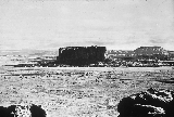
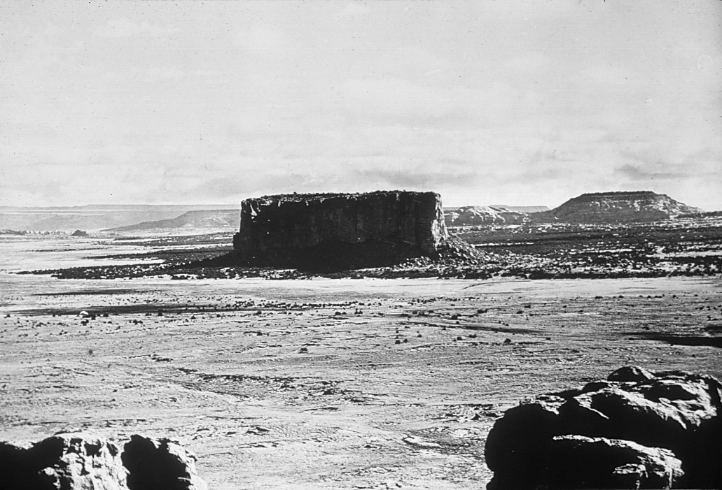
Enchanted Mesa
Encyclopedia
Butte
A butte is a conspicuous isolated hill with steep, often vertical sides and a small, relatively flat top; it is smaller than mesas, plateaus, and table landform tables. In some regions, such as the north central and northwestern United States, the word is used for any hill...
in Cibola County
Cibola County, New Mexico
-2010:Whereas according to the 2010 U.S. Census Bureau:*41.8% White*1.0% Black*41.0% Native American*0.5% Asian*0.1% Native Hawaiian or Pacific Islander*3.1% Two or more races*12.5% Other races*36.5% Hispanic or Latino -2000:...
, New Mexico, United States, about 2.5 miles (4 km) northeast of the pueblo of Acoma
Acoma Pueblo
Acoma Pueblo is a Native American pueblo approximately 60 miles west of Albuquerque, New Mexico in the United States. Three reservations make up Acoma Pueblo: Sky City , Acomita, and McCartys. The Acoma Pueblo tribe is a federally recognized tribal entity...
. It is called Mesa Encantada in Spanish and Katzimo or Kadzima in Keresan
Keresan languages
Keresan , also Keres , is a group of seven related languages spoken by Keres Pueblo peoples in New Mexico, U.S.A.. Each is mutually intelligible with its closest neighbors...
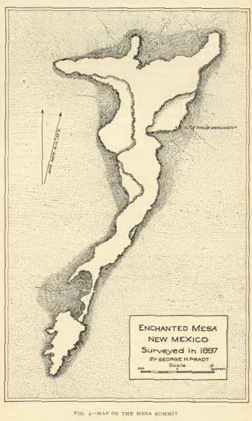
. Acoma tradition says that Enchanted Mesa was the home of the Acoma people until a severe storm and landslide destroyed the only approach. There are no longer any ruins on the flat top. The butte is high, long and only ft wide, at its widest. The elevation at the top is .
History
In 1892, when Charles F. LummisCharles Fletcher Lummis
Charles Fletcher Lummis was a United States journalist and Indian activist; he is also acclaimed as a historian, photographer, poet and librarian....
was visiting Acoma he listened to the old Indian governor, Martín Valle, who told the story of how the Acoma people used to live on Enchanted Mesa. Their access to the top was on the southern side where a large piece of the butte had spalled off and formed a ramp, a "stone ladder", up to the top. Their fields, and the springs that were their water source, were in the valley. In the summer, the entire village would descend into the valley to tend the crops. One afternoon a severe thunderstorm washed away the "stone ladder", leaving only sheer rock faces all the way around the butte. Legend has it that three old women and a young boy had been left in the village, but they could not get down, nor could anyone else get back to the village. A giant thunderbird swooped down and scooped up the four and carried them to the valley floor. The Acoma people abandoned Enchanted Mesa and moved to White Rock Mesa, now called Acoma.
In 1897, Professor William Libbey
William Libbey
William A. Libbey III was an American professor of physical geography at Princeton University. He was twice a member of the U.S. Olympic Rifle Team, and rose to the rank of colonel in the New Jersey National Guard...
from Princeton University climbed Enchanted Mesa to disprove the existence of ruins. His team used a cannon to shoot a rope over the end of the butte and using a pulley pulled himself up in a marine life-saving chair. Libbey and a newspaperman climbed to the top, spent two to three hours exploring, and returned empty-handed. Libbey announced that he had seen no ruins or artifacts, saying "Romantic Indian legend can never stand the acid test of scientific investigation." Archaeologist Frederick Webb Hodge did not take Libbey's word for it, and on a later expedition found plenty of evidence of occupation. Although the main ruins had been washed over the edge by centuries of thunderstorms, he found plenty of arrow points, stone tools, beads and pottery fragments lodged in crevices.
On 18 November 1974, an Acoma police officer indicated that he had seen a UFO over Enchanted Mesa. Over the next several days, other officers reported "a red light, faster than any aircraft". A helicopter was dispatched to the top with the governor of the pueblo and a police officer, but no direct evidence of a UFO was found.
Geology
The massive cliffs are formed by the Zuni Sandstone and the butte is topped by the Dakota SandstoneDakota Formation
The Dakota Formation is a geologic formation composed of sedimentary rocks deposited on the western side of the Late Cretaceous Western Interior Seaway. F.B. Meek and F.V. Hayden named it for exposures along the Missouri River near Dakota City, Nebraska...
.