

Elkhorn, California
Encyclopedia
Elkhorn is a census-designated place
(CDP) in Monterey County
, California
, United States
. Elkhorn was a stop on the Southern Pacific Railroad
13 miles (21 km) northwest of Prunedale
, at an elevation of 10 feet (3 m). The population of Elkhorn was 1,565 at the 2010 census, down from 1,591 at the 2000 census. Elkhorn was named after the elk in the area that have since gone extinct. Because Elkhorn is not incorporated, not all residents call the place they live Elkhorn. Some residents refer to Elkhorn as Castroville
, Prunedale, Watsonville
, or Salinas
on mailed documents because Elkhorn shares ZIP code
s with them. Other residents refer to Elkhorn as north Monterey County of which Elkhorn is a part. The Elkhorn Slough National Estuarine Research Reserve
, located in the area, promotes education about and preservation of the largest tidal salt marsh outside of San Francisco Bay, Elkhorn Slough
.
According to the United States Census Bureau
, the CDP has a total area of 4.8 square miles (12.4 km²), of which, 4.8 square miles (12.4 km²) of it is land and 0.02 square mile (0.0517997622 km²) of it (0.47%) is water.
was 324.0 people per square mile (125.1/km²). The racial makeup of Elkhorn was 1,122 (71.7%) White, 9 (0.6%) African American, 7 (0.4%) Native American, 63 (4.0%) Asian, 3 (0.2%) Pacific Islander, 286 (18.3%) from other races
, and 75 (4.8%) from two or more races. Hispanic or Latino of any race were 588 persons (37.6%).
The Census reported that 1,565 people (100% of the population) lived in households, 0 (0%) lived in non-institutionalized group quarters, and 0 (0%) were institutionalized.
There were 532 households, out of which 183 (34.4%) had children under the age of 18 living in them, 329 (61.8%) were opposite-sex married couples
living together, 58 (10.9%) had a female householder with no husband present, 27 (5.1%) had a male householder with no wife present. There were 33 (6.2%) unmarried opposite-sex partnerships
, and 2 (0.4%) same-sex married couples or partnerships. 95 households (17.9%) were made up of individuals and 29 (5.5%) had someone living alone who was 65 years of age or older. The average household size was 2.94. There were 414 families
(77.8% of all households); the average family size was 3.21.
The population was spread out with 364 people (23.3%) under the age of 18, 149 people (9.5%) aged 18 to 24, 349 people (22.3%) aged 25 to 44, 519 people (33.2%) aged 45 to 64, and 184 people (11.8%) who were 65 years of age or older. The median age was 41.5 years. For every 100 females there were 97.4 males. For every 100 females age 18 and over, there were 97.5 males.
There were 565 housing units at an average density of 117.0 per square mile (45.2/km²), of which 380 (71.4%) were owner-occupied, and 152 (28.6%) were occupied by renters. The homeowner vacancy rate was 1.3%; the rental vacancy rate was 0.6%. 1,098 people (70.2% of the population) lived in owner-occupied housing units and 467 people (29.8%) lived in rental housing units.
of 2000, there were 1,591 people, 523 households, and 411 families residing in the CDP. The population density
was 327.4 people per square mile (126.4/km²). There were 542 housing units at an average density of 111.5 per square mile (43.1/km²). Most residents live in detached single family homes with land, individual and shared water wells and leach fields. The racial makeup of the CDP was 72.16% White
, 1.01% Black
or African American
, 0.63% Native American
, 3.83% Asian
, 0.13% Pacific Islander
, 18.29% from other races
, and 3.96% from two or more races. 27.91% of the population were Hispanic or Latino
of any race.
There were 523 households out of which 35.4% had children under the age of 18 living with them, 65.8% were married couples
living together, 8.8% had a female householder with no husband present, and 21.4% were non-families. 14.1% of all households were made up of individuals and 3.3% had someone living alone who was 65 years of age or older. The average household size was 3.04 and the average family size was 3.34.
In the CDP the population was spread out with 25.7% under the age of 18, 7.6% from 18 to 24, 29.0% from 25 to 44, 28.5% from 45 to 64, and 9.2% who were 65 years of age or older. The median age was 38 years. For every 100 females there were 103.7 males. For every 100 females age 18 and over, there were 104.5 males.
The median income for a household in the CDP was $70,370, and the median income for a family was $71,296. Males had a median income of $40,662 versus $36,274 for females. The per capita income
for the CDP was $24,999. About 4.5% of families and 9.8% of the population were below the poverty line, including 5.7% of those under age 18 and 15.2% of those age 65 or over.
.
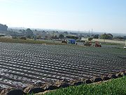 Agricultural is a major part of Elkhorn's small economy. Strawberries and artichokes are key crops. Most Elkhorn residents work in the surrounding areas of Castroville
, Prunedale
, Moss Landing
, and the nearby larger towns of Watsonville
, Salinas
, and Monterey
. Elkhorn shares zip codes with nearby Castroville, Watsonville, and Prunedale. Elkhorn has limited business and retail services. The only retail service in Elkhorn is the Elkhorn Superette which is located on the west side of Elkhorn Road, just north of Bayview Road. The nearest business and retail center is located about three miles (5 km) away in Castroville. However, many Elkhorn residents travel about 20 minutes to the nearby cities for greater retail and service needs such as department stores, movie theaters, and health services which are not located in Castroville.
. Dolan Road provides access to Highway 1
. Minor county roads include: Del Monte Farms, Bayview Road, Walker Valley Road, Long Valley Road, Amaral Road, Paradise Canyon Road.
, both located in Castroville. All local public schools are part of the North Monterey County Unified School District
http://www.nmcusd.org/.
Census-designated place
A census-designated place is a concentration of population identified by the United States Census Bureau for statistical purposes. CDPs are delineated for each decennial census as the statistical counterparts of incorporated places such as cities, towns and villages...
(CDP) in Monterey County
Monterey County, California
Monterey County is a county located on the Pacific coast of the U.S. state of California, its northwestern section forming the southern half of Monterey Bay. The northern half of the bay is in Santa Cruz County. As of 2010, the population was 415,057. The county seat and largest city is Salinas...
, California
California
California is a state located on the West Coast of the United States. It is by far the most populous U.S. state, and the third-largest by land area...
, United States
United States
The United States of America is a federal constitutional republic comprising fifty states and a federal district...
. Elkhorn was a stop on the Southern Pacific Railroad
Southern Pacific Railroad
The Southern Pacific Transportation Company , earlier Southern Pacific Railroad and Southern Pacific Company, and usually simply called the Southern Pacific or Espee, was an American railroad....
13 miles (21 km) northwest of Prunedale
Prunedale, California
Prunedale is a census-designated place in Monterey County, California, United States. Prunedale is located north of Salinas, at an elevation of 92 feet . The population was 17,560 residents at the time of the 2010 census, up from 16,432 at the 2000 census...
, at an elevation of 10 feet (3 m). The population of Elkhorn was 1,565 at the 2010 census, down from 1,591 at the 2000 census. Elkhorn was named after the elk in the area that have since gone extinct. Because Elkhorn is not incorporated, not all residents call the place they live Elkhorn. Some residents refer to Elkhorn as Castroville
Castroville, California
Castroville is a census-designated place in Monterey County, California, United States. Castroville is located northwest of Salinas, at an elevation of 23 feet . The population was 6,481 at the 2010 census, down from 6,724 at the 2000 census. Castroville calls itself "Artichoke Center of the...
, Prunedale, Watsonville
Watsonville, California
Watsonville is a city in Santa Cruz County, California, United States. The population was 51,199 according to the 2010 census.Located on the central coast of California, the economy centers predominantly around the farming industry. It is known for growing strawberries, apples, lettuce and a host...
, or Salinas
Salinas, California
Salinas is the county seat and the largest municipality of Monterey County, California. Salinas is located east-southeast of the mouth of the Salinas River, at an elevation of about 52 feet above sea level. The population was 150,441 at the 2010 census...
on mailed documents because Elkhorn shares ZIP code
ZIP Code
ZIP codes are a system of postal codes used by the United States Postal Service since 1963. The term ZIP, an acronym for Zone Improvement Plan, is properly written in capital letters and was chosen to suggest that the mail travels more efficiently, and therefore more quickly, when senders use the...
s with them. Other residents refer to Elkhorn as north Monterey County of which Elkhorn is a part. The Elkhorn Slough National Estuarine Research Reserve
Elkhorn Slough National Estuarine Research Reserve
The Elkhorn Slough National Estuarine Research Reserve is one of 28 National Estuarine Research Reserves established nationwide as field laboratories for scientific research and estuarine education. The Slough is located approximately south of San Francisco, California on the central shore of...
, located in the area, promotes education about and preservation of the largest tidal salt marsh outside of San Francisco Bay, Elkhorn Slough
Elkhorn Slough
Elkhorn Slough is a tidal slough and estuary on Monterey Bay in Monterey County, California. The community of Moss Landing and the huge Moss Landing Power Plant are located at the mouth of the slough on the bay....
.
Geography
Elkhorn is located at 36°49′28"N 121°44′26"W.According to the United States Census Bureau
United States Census Bureau
The United States Census Bureau is the government agency that is responsible for the United States Census. It also gathers other national demographic and economic data...
, the CDP has a total area of 4.8 square miles (12.4 km²), of which, 4.8 square miles (12.4 km²) of it is land and 0.02 square mile (0.0517997622 km²) of it (0.47%) is water.
2010
The 2010 United States Census reported that Elkhorn had a population of 1,565. The population densityPopulation density
Population density is a measurement of population per unit area or unit volume. It is frequently applied to living organisms, and particularly to humans...
was 324.0 people per square mile (125.1/km²). The racial makeup of Elkhorn was 1,122 (71.7%) White, 9 (0.6%) African American, 7 (0.4%) Native American, 63 (4.0%) Asian, 3 (0.2%) Pacific Islander, 286 (18.3%) from other races
Race (United States Census)
Race and ethnicity in the United States Census, as defined by the Federal Office of Management and Budget and the United States Census Bureau, are self-identification data items in which residents choose the race or races with which they most closely identify, and indicate whether or not they are...
, and 75 (4.8%) from two or more races. Hispanic or Latino of any race were 588 persons (37.6%).
The Census reported that 1,565 people (100% of the population) lived in households, 0 (0%) lived in non-institutionalized group quarters, and 0 (0%) were institutionalized.
There were 532 households, out of which 183 (34.4%) had children under the age of 18 living in them, 329 (61.8%) were opposite-sex married couples
Marriage
Marriage is a social union or legal contract between people that creates kinship. It is an institution in which interpersonal relationships, usually intimate and sexual, are acknowledged in a variety of ways, depending on the culture or subculture in which it is found...
living together, 58 (10.9%) had a female householder with no husband present, 27 (5.1%) had a male householder with no wife present. There were 33 (6.2%) unmarried opposite-sex partnerships
POSSLQ
POSSLQ is an abbreviation for "Persons of Opposite Sex Sharing Living Quarters," a term coined in the late 1970s by the United States Census Bureau as part of an effort to more accurately gauge the prevalence of cohabitation in American households....
, and 2 (0.4%) same-sex married couples or partnerships. 95 households (17.9%) were made up of individuals and 29 (5.5%) had someone living alone who was 65 years of age or older. The average household size was 2.94. There were 414 families
Family (U.S. Census)
A family or family household is defined by the United States Census Bureau for statistical purposes as "a householder and one or more other people related to the householder by birth, marriage, or adoption. They do not include same-sex married couples even if the marriage was performed in a state...
(77.8% of all households); the average family size was 3.21.
The population was spread out with 364 people (23.3%) under the age of 18, 149 people (9.5%) aged 18 to 24, 349 people (22.3%) aged 25 to 44, 519 people (33.2%) aged 45 to 64, and 184 people (11.8%) who were 65 years of age or older. The median age was 41.5 years. For every 100 females there were 97.4 males. For every 100 females age 18 and over, there were 97.5 males.
There were 565 housing units at an average density of 117.0 per square mile (45.2/km²), of which 380 (71.4%) were owner-occupied, and 152 (28.6%) were occupied by renters. The homeowner vacancy rate was 1.3%; the rental vacancy rate was 0.6%. 1,098 people (70.2% of the population) lived in owner-occupied housing units and 467 people (29.8%) lived in rental housing units.
2000
As of the censusCensus
A census is the procedure of systematically acquiring and recording information about the members of a given population. It is a regularly occurring and official count of a particular population. The term is used mostly in connection with national population and housing censuses; other common...
of 2000, there were 1,591 people, 523 households, and 411 families residing in the CDP. The population density
Population density
Population density is a measurement of population per unit area or unit volume. It is frequently applied to living organisms, and particularly to humans...
was 327.4 people per square mile (126.4/km²). There were 542 housing units at an average density of 111.5 per square mile (43.1/km²). Most residents live in detached single family homes with land, individual and shared water wells and leach fields. The racial makeup of the CDP was 72.16% White
Race (United States Census)
Race and ethnicity in the United States Census, as defined by the Federal Office of Management and Budget and the United States Census Bureau, are self-identification data items in which residents choose the race or races with which they most closely identify, and indicate whether or not they are...
, 1.01% Black
Race (United States Census)
Race and ethnicity in the United States Census, as defined by the Federal Office of Management and Budget and the United States Census Bureau, are self-identification data items in which residents choose the race or races with which they most closely identify, and indicate whether or not they are...
or African American
Race (United States Census)
Race and ethnicity in the United States Census, as defined by the Federal Office of Management and Budget and the United States Census Bureau, are self-identification data items in which residents choose the race or races with which they most closely identify, and indicate whether or not they are...
, 0.63% Native American
Race (United States Census)
Race and ethnicity in the United States Census, as defined by the Federal Office of Management and Budget and the United States Census Bureau, are self-identification data items in which residents choose the race or races with which they most closely identify, and indicate whether or not they are...
, 3.83% Asian
Race (United States Census)
Race and ethnicity in the United States Census, as defined by the Federal Office of Management and Budget and the United States Census Bureau, are self-identification data items in which residents choose the race or races with which they most closely identify, and indicate whether or not they are...
, 0.13% Pacific Islander
Race (United States Census)
Race and ethnicity in the United States Census, as defined by the Federal Office of Management and Budget and the United States Census Bureau, are self-identification data items in which residents choose the race or races with which they most closely identify, and indicate whether or not they are...
, 18.29% from other races
Race (United States Census)
Race and ethnicity in the United States Census, as defined by the Federal Office of Management and Budget and the United States Census Bureau, are self-identification data items in which residents choose the race or races with which they most closely identify, and indicate whether or not they are...
, and 3.96% from two or more races. 27.91% of the population were Hispanic or Latino
Race (United States Census)
Race and ethnicity in the United States Census, as defined by the Federal Office of Management and Budget and the United States Census Bureau, are self-identification data items in which residents choose the race or races with which they most closely identify, and indicate whether or not they are...
of any race.
There were 523 households out of which 35.4% had children under the age of 18 living with them, 65.8% were married couples
Marriage
Marriage is a social union or legal contract between people that creates kinship. It is an institution in which interpersonal relationships, usually intimate and sexual, are acknowledged in a variety of ways, depending on the culture or subculture in which it is found...
living together, 8.8% had a female householder with no husband present, and 21.4% were non-families. 14.1% of all households were made up of individuals and 3.3% had someone living alone who was 65 years of age or older. The average household size was 3.04 and the average family size was 3.34.
In the CDP the population was spread out with 25.7% under the age of 18, 7.6% from 18 to 24, 29.0% from 25 to 44, 28.5% from 45 to 64, and 9.2% who were 65 years of age or older. The median age was 38 years. For every 100 females there were 103.7 males. For every 100 females age 18 and over, there were 104.5 males.
The median income for a household in the CDP was $70,370, and the median income for a family was $71,296. Males had a median income of $40,662 versus $36,274 for females. The per capita income
Per capita income
Per capita income or income per person is a measure of mean income within an economic aggregate, such as a country or city. It is calculated by taking a measure of all sources of income in the aggregate and dividing it by the total population...
for the CDP was $24,999. About 4.5% of families and 9.8% of the population were below the poverty line, including 5.7% of those under age 18 and 15.2% of those age 65 or over.
Government
As an unincorporated area, the Monterey County Board of Supervisors administers Elkhorn. Elkhorn is part of District 2 whose current supervisor is Louis R. Calcagno. The Board is responsible for providing all local public services. Elkhorn is located in the Coastal Zone and all new development is subject to approval by the California Coastal CommissionCalifornia Coastal Commission
The California Coastal Commission is a state agency in the U.S. state of California with quasi-judicial regulatory oversight over land use and public access in the California coastal zone....
.
Industry
Castroville, California
Castroville is a census-designated place in Monterey County, California, United States. Castroville is located northwest of Salinas, at an elevation of 23 feet . The population was 6,481 at the 2010 census, down from 6,724 at the 2000 census. Castroville calls itself "Artichoke Center of the...
, Prunedale
Prunedale, California
Prunedale is a census-designated place in Monterey County, California, United States. Prunedale is located north of Salinas, at an elevation of 92 feet . The population was 17,560 residents at the time of the 2010 census, up from 16,432 at the 2000 census...
, Moss Landing
Moss Landing, California
Moss Landing is a census-designated place in Monterey County, California, United States. Moss Landing is located on the Pajaro Valley Consolidated Railroad north-northeast of Monterey, at an elevation of 10 feet . As of the 2010 census, the CDP population was 204, down from 300 at the 2000...
, and the nearby larger towns of Watsonville
Watsonville, California
Watsonville is a city in Santa Cruz County, California, United States. The population was 51,199 according to the 2010 census.Located on the central coast of California, the economy centers predominantly around the farming industry. It is known for growing strawberries, apples, lettuce and a host...
, Salinas
Salinas, California
Salinas is the county seat and the largest municipality of Monterey County, California. Salinas is located east-southeast of the mouth of the Salinas River, at an elevation of about 52 feet above sea level. The population was 150,441 at the 2010 census...
, and Monterey
Monterey, California
The City of Monterey in Monterey County is located on Monterey Bay along the Pacific coast in Central California. Monterey lies at an elevation of 26 feet above sea level. As of the 2010 census, the city population was 27,810. Monterey is of historical importance because it was the capital of...
. Elkhorn shares zip codes with nearby Castroville, Watsonville, and Prunedale. Elkhorn has limited business and retail services. The only retail service in Elkhorn is the Elkhorn Superette which is located on the west side of Elkhorn Road, just north of Bayview Road. The nearest business and retail center is located about three miles (5 km) away in Castroville. However, many Elkhorn residents travel about 20 minutes to the nearby cities for greater retail and service needs such as department stores, movie theaters, and health services which are not located in Castroville.
Streets
Main county roads include: Castroville Boulevard, Dolan Road, Elkhorn Road, and Meridian Road. Castroville Boulevard provides access to Highway 156California State Route 156
State Route 156 is a state highway in California, USA, running from Castroville to State Route 152 near Hollister.This route is eligible for the State Scenic Highway System.-Route description:...
. Dolan Road provides access to Highway 1
California State Route 1
State Route 1 , more often called Highway 1, is a state highway that runs along much of the Pacific coast of the U.S. state of California. It is famous for running along some of the most beautiful coastlines in the world, leading to its designation as an All-American Road.Highway 1 does not run...
. Minor county roads include: Del Monte Farms, Bayview Road, Walker Valley Road, Long Valley Road, Amaral Road, Paradise Canyon Road.
Schools
Elkhorn Elementary School is the only school located in Elkhorn, and it serves the surrounding K-6 student population. Elkhorn Elementary is the polling site for Elkhorn voters. Middle school students in grades 7 and 8 currently attend North Monterey County Middle School and high school students in grades 9-12 attend North Monterey County High SchoolNorth Monterey County High School
North Monterey County High School is a high school in Castroville, California and was founded in 1978. The high school serves the populations of Aromas, Castroville, Prunedale, Royal Oaks, Elkhorn, and portions of Salinas. North Monterey County High School is part of the North Monterey County...
, both located in Castroville. All local public schools are part of the North Monterey County Unified School District
North Monterey County Unified School District
North Monterey County Unified School Districtor NMCUSD is a school district in northern Monterey County. The school district serves 5581 pupils in the communities of Aromas, Castroville, Elkhorn, Prunedale, Royal Oaks, Moss Landing, and portions of Salinas, California. The district's average...
http://www.nmcusd.org/.