

Elizabeth, West Virginia
Encyclopedia
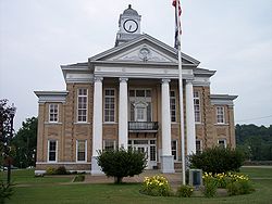
Wirt County, West Virginia
As of the census of 2000, there were 5,873 people, 2,284 households, and 1,699 families residing in the county. The population density was 25 people per square mile . There were 3,266 housing units at an average density of 14 per square mile...
, West Virginia
West Virginia
West Virginia is a state in the Appalachian and Southeastern regions of the United States, bordered by Virginia to the southeast, Kentucky to the southwest, Ohio to the northwest, Pennsylvania to the northeast and Maryland to the east...
along the Little Kanawha River
Little Kanawha River
The Little Kanawha River is a tributary of the Ohio River, 169 mi long, in western West Virginia in the United States. Via the Ohio, it is part of the watershed of the Mississippi River, draining an area of 2,320 mi² on the unglaciated portion of the Allegheny Plateau...
. The population was 994 at the 2000 census. It is the county seat
County seat
A county seat is an administrative center, or seat of government, for a county or civil parish. The term is primarily used in the United States....
of Wirt County
Wirt County, West Virginia
As of the census of 2000, there were 5,873 people, 2,284 households, and 1,699 families residing in the county. The population density was 25 people per square mile . There were 3,266 housing units at an average density of 14 per square mile...
. The townsite of Elizabeth was settled
Settler
A settler is a person who has migrated to an area and established permanent residence there, often to colonize the area. Settlers are generally people who take up residence on land and cultivate it, as opposed to nomads...
by William Beauchamp in 1796, and was known as "Beauchamp's Mills" until 1817, when it was named for Elizabeth Woodyard, the wife of David Beauchamp. Elizabeth was chartered
Municipal charter
A city charter or town charter is a legal document establishing a municipality such as a city or town. The concept developed in Europe during the middle ages....
by the Virginia General Assembly
Virginia General Assembly
The Virginia General Assembly is the legislative body of the Commonwealth of Virginia, and the oldest legislative body in the Western Hemisphere, established on July 30, 1619. The General Assembly is a bicameral body consisting of a lower house, the Virginia House of Delegates, with 100 members,...
in 1822.
Geography
Elizabeth is located at 39°3′46"N 81°23′44"W (39.062852, -81.395529).According to the United States Census Bureau
United States Census Bureau
The United States Census Bureau is the government agency that is responsible for the United States Census. It also gathers other national demographic and economic data...
, the town has a total area of 0.5 square mile (1.4 km²), of which 0.5 square mile (1.2 km²) is land and 0.1 square mile (0.2 km²) (11.32%) is water.
Demographics
As of the censusCensus
A census is the procedure of systematically acquiring and recording information about the members of a given population. It is a regularly occurring and official count of a particular population. The term is used mostly in connection with national population and housing censuses; other common...
of 2000, there were 994 people, 408 households, and 261 families residing in the town. The population density
Population density
Population density is a measurement of population per unit area or unit volume. It is frequently applied to living organisms, and particularly to humans...
was 2,091.3 inhabitants per square mile (799.6/km²). There were 466 housing units at an average density of 980.4 per square mile (374.8/km²). The racial makeup of the town was 99.20% White, 0.10% African American, 0.20% Native American, 0.30% from other races
Race (United States Census)
Race and ethnicity in the United States Census, as defined by the Federal Office of Management and Budget and the United States Census Bureau, are self-identification data items in which residents choose the race or races with which they most closely identify, and indicate whether or not they are...
, and 0.20% from two or more races.
There were 408 households out of which 37.5% had children under the age of 18 living with them, 43.9% were married couples
Marriage
Marriage is a social union or legal contract between people that creates kinship. It is an institution in which interpersonal relationships, usually intimate and sexual, are acknowledged in a variety of ways, depending on the culture or subculture in which it is found...
living together, 15.9% had a female householder with no husband present, and 36.0% were non-families. 33.3% of all households were made up of individuals and 19.9% had someone living alone who was 65 years of age or older. The average household size was 2.38 and the average family size was 2.98.
In the town the population was spread out with 28.3% under the age of 18, 8.2% from 18 to 24, 29.1% from 25 to 44, 19.7% from 45 to 64, and 14.7% who were 65 years of age or older. The median age was 34 years. For every 100 females there were 84.8 males. For every 100 females age 18 and over, there were 76.5 males.
The median income for a household in the town was $25,114, and the median income for a family was $30,104. Males had a median income of $24,306 versus $17,813 for females. The per capita income
Per capita income
Per capita income or income per person is a measure of mean income within an economic aggregate, such as a country or city. It is calculated by taking a measure of all sources of income in the aggregate and dividing it by the total population...
for the town was $12,704. About 20.2% of families and 23.8% of the population were below the poverty line, including 23.0% of those under age 18 and 18.5% of those age 65 or over.