Eina
Encyclopedia
Eina is a village in Vestre Toten
municipality, Oppland
, Norway
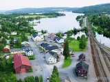
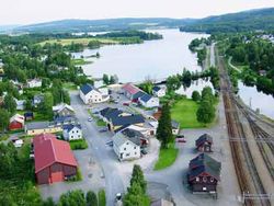
. The population is 677. The village is one of the destinations on the railroad track Gjøvikbanen
, between Jaren
and Raufoss
.
Eina is located a mere 12 km south of Raufoss
, and has its center just north of Einavatnet
(or Einafjorden). From Einavatnet
comes the river Hunnselva
which travels north to Mjøsa
. Some 1,500 people inhabit the area surrounding the lake, not including Eina.

being built, which brought passengers and freight to and through the village. In 1902, the local railroad station stood ready, and in 1908 Eina would become a municipality on its own when Vestre Toten
split into three (Eina, Kolbu
and Vestre Toten). At this time, Eina had 1,173 inhabitants, and was experiencing significant economic growth. In 1964, Eina merged with Vestre Toten
, by then having grown to 1,591 inhabitants.
Valdresbanen was built in 1906, and was originally a privately owned line, until the government assumed control in 1937. It covered the distance from Eina to Fagernes
, which is located in Nord-Aurdal
. The track was 109 km long, and was closed in 1988.
Vestre Toten
Vestre Toten is a municipality in Oppland county, Norway. It is part of the traditional region of Toten. The administrative centre of the municipality is the village of Raufoss.-Name:...
municipality, Oppland
Oppland
is a county in Norway, bordering Sør-Trøndelag, Møre og Romsdal, Sogn og Fjordane, Buskerud, Akershus, Oslo and Hedmark. The county administration is in Lillehammer. Oppland is, together with Hedmark, one of the only two landlocked counties of Norway....
, Norway
Norway
Norway , officially the Kingdom of Norway, is a Nordic unitary constitutional monarchy whose territory comprises the western portion of the Scandinavian Peninsula, Jan Mayen, and the Arctic archipelago of Svalbard and Bouvet Island. Norway has a total area of and a population of about 4.9 million...
. The population is 677. The village is one of the destinations on the railroad track Gjøvikbanen
Gjøvikbanen
The Gjøvik Line is a Norwegian railway line between Oslo and Gjøvik. It was originally named the North Line and ran between Grefsen and Røykenvik. The line was completed to Gjøvik in 1902...
, between Jaren
Jaren
Jaren is the administrative centre of Gran municipality, Norway. Together with Brandbu it forms an urban area with a population of 4,423....
and Raufoss
Raufoss
Raufoss is the municipal centre of Vestre Toten, a municipality in the county of Oppland, Norway, 10 kilomenters south of the larger town Gjøvik. It has approximately 6,000 inhabitants. The largest employer is what was earlier Raufoss Ammunitions factory, now split into several sub companies...
.
Eina is located a mere 12 km south of Raufoss
Raufoss
Raufoss is the municipal centre of Vestre Toten, a municipality in the county of Oppland, Norway, 10 kilomenters south of the larger town Gjøvik. It has approximately 6,000 inhabitants. The largest employer is what was earlier Raufoss Ammunitions factory, now split into several sub companies...
, and has its center just north of Einavatnet
Einavatnet
Einavatnet is a lake which lies in Vestre Toten municipality in Oppland county, Norway. It has an area of 13.52 km² and is 39.54 km around. It lies at an elevation of 398 m above sea level.-Name:...
(or Einafjorden). From Einavatnet
Einavatnet
Einavatnet is a lake which lies in Vestre Toten municipality in Oppland county, Norway. It has an area of 13.52 km² and is 39.54 km around. It lies at an elevation of 398 m above sea level.-Name:...
comes the river Hunnselva
Hunnselva
Hunnselva is a river in Norway which runs from the end of Einafjorden through the village of Eina in Vestre Toten municipality, northwards through Reinsvoll, Raufoss and Hunndalen before it runs into Mjøsa in Gjøvik...
which travels north to Mjøsa
Mjøsa
Mjøsa is Norway's largest lake, as well as one of the deepest lakes in Norway and in Europe as a whole, after Hornindalsvatnet. It is located in the southern part of Norway, about 100 km north of Oslo...
. Some 1,500 people inhabit the area surrounding the lake, not including Eina.

History
The area has been populated since before the early 11th century, but did not see significant growth until the Norwegian industrialization. This was due to the railroad line GjøvikbanenGjøvikbanen
The Gjøvik Line is a Norwegian railway line between Oslo and Gjøvik. It was originally named the North Line and ran between Grefsen and Røykenvik. The line was completed to Gjøvik in 1902...
being built, which brought passengers and freight to and through the village. In 1902, the local railroad station stood ready, and in 1908 Eina would become a municipality on its own when Vestre Toten
Vestre Toten
Vestre Toten is a municipality in Oppland county, Norway. It is part of the traditional region of Toten. The administrative centre of the municipality is the village of Raufoss.-Name:...
split into three (Eina, Kolbu
Kolbu
Kolbu is a village in Østre Toten municipality, Oppland county, Norway. It is located in the traditional region of Toten. Kolbu is situated about six kilometers southwest of the municipal center of Lena....
and Vestre Toten). At this time, Eina had 1,173 inhabitants, and was experiencing significant economic growth. In 1964, Eina merged with Vestre Toten
Vestre Toten
Vestre Toten is a municipality in Oppland county, Norway. It is part of the traditional region of Toten. The administrative centre of the municipality is the village of Raufoss.-Name:...
, by then having grown to 1,591 inhabitants.
Valdresbanen
Eina was also connected to Valdresbanen, another railroad line, until it closed.Valdresbanen was built in 1906, and was originally a privately owned line, until the government assumed control in 1937. It covered the distance from Eina to Fagernes
Fagernes
is the largest settlement in the valley of Valdres, Norway, with a population of 1,801. Fagernes is the administrative centre of the municipality of Nord-Aurdal.See video from the Fagernes Town : *...
, which is located in Nord-Aurdal
Nord-Aurdal
Nord-Aurdal is a municipality in Oppland county, Norway. It is part of the traditional region of Valdres. The administrative centre of the municipality is the village of Fagernes....
. The track was 109 km long, and was closed in 1988.

