

Eggardon Hill
Encyclopedia
Bridport
Bridport is a market town in Dorset, England. Located near the coast at the western end of Chesil Beach at the confluence of the River Brit and its Asker and Simene tributaries, it originally thrived as a fishing port and rope-making centre...
, in the English county of Dorset
Dorset
Dorset , is a county in South West England on the English Channel coast. The county town is Dorchester which is situated in the south. The Hampshire towns of Bournemouth and Christchurch joined the county with the reorganisation of local government in 1974...
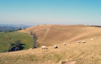
. It stands 250 metres (820 feet) above sea level, and provides panoramic views to the south, north and west. The southern half of the hill is owned and maintained by The National Trust
National Trust for Places of Historic Interest or Natural Beauty
The National Trust for Places of Historic Interest or Natural Beauty, usually known as the National Trust, is a conservation organisation in England, Wales and Northern Ireland...
(which permits free public access throughout the year) with the northern part in private ownership.
Eggardon Hill is first documented in the Domesday Book
Domesday Book
Domesday Book , now held at The National Archives, Kew, Richmond upon Thames in South West London, is the record of the great survey of much of England and parts of Wales completed in 1086...
of 1086. From about 300 BC
300 BC
Year 300 BC was a year of the pre-Julian Roman calendar. At the time it was known as the Year of the Consulship of Corvus and Pansa...
, it was used as a hill fort
Hill fort
A hill fort is a type of earthworks used as a fortified refuge or defended settlement, located to exploit a rise in elevation for defensive advantage. They are typically European and of the Bronze and Iron Ages. Some were used in the post-Roman period...
— an Iron Age
Iron Age
The Iron Age is the archaeological period generally occurring after the Bronze Age, marked by the prevalent use of iron. The early period of the age is characterized by the widespread use of iron or steel. The adoption of such material coincided with other changes in society, including differing...
defended settlement. It is usually held that such forts were captured and forcibly vacated by the Romans
Roman Empire
The Roman Empire was the post-Republican period of the ancient Roman civilization, characterised by an autocratic form of government and large territorial holdings in Europe and around the Mediterranean....
during the Claudian Invasion of 43
43
Year 43 was a common year starting on Tuesday of the Julian calendar. At the time, it was known as the Year of the Consulship of Caesar and Vitellius...
AD, although there is only indirect evidence for this; Eggardon Hill itself has never been excavated by archaeologists. The presence of several tumuli
Tumulus
A tumulus is a mound of earth and stones raised over a grave or graves. Tumuli are also known as barrows, burial mounds, Hügelgrab or kurgans, and can be found throughout much of the world. A tumulus composed largely or entirely of stones is usually referred to as a cairn...
(or barrows) on the hill provides another indication of prehistoric use.
Latterly, notorious smuggler Isaac Gulliver
Isaac Gulliver
The name of three generations of Gullivers from Semington in Wiltshire, England during the 18th and early 19th century; Isaac Gulliver was so successful as a smuggler on the south coast that he came to control its length from Lymington on The Solent in Hampshire, through Dorset to Torbay on the...
(1745-1822) (who owned Eggardon Hill Farm) is reputed to have planted a stand of pine trees on Eggardon Hill, to provide an aid to navigation for his ships as they approached the Dorset coast. Although the trees were later felled on government orders, the octagonal earthworks
Earthworks (engineering)
Earthworks are engineering works created through the moving or processing of quantities of soil or unformed rock.- Civil engineering use :Typical earthworks include roads, railway beds, causeways, dams, levees, canals, and berms...
used to protect them from the elements is still visible today, and marked on Ordnance Survey
Ordnance Survey
Ordnance Survey , an executive agency and non-ministerial government department of the Government of the United Kingdom, is the national mapping agency for Great Britain, producing maps of Great Britain , and one of the world's largest producers of maps.The name reflects its creation together with...
maps of the area.
The name Eggardon is derived from an Old English
Old English language
Old English or Anglo-Saxon is an early form of the English language that was spoken and written by the Anglo-Saxons and their descendants in parts of what are now England and southeastern Scotland between at least the mid-5th century and the mid-12th century...
place name, meaning the hill belonging to Eohhere.