

Ebstorf Map
Encyclopedia
Mappa mundi
Mappa mundi is a general term used to describe medieval European maps of the world. These maps range in size and complexity from simple schematic maps an inch or less across to elaborate wall maps, the largest of which was 11 ft. in diameter...
(a Medieval European map of the world) similar to the Hereford Map
Hereford Mappa Mundi
The Hereford Mappa Mundi is a mappa mundi, of a form deriving from the T and O pattern, dating to ca. 1300. It is currently on display in Hereford Cathedral in Hereford, England...
, made by Gervase of Ebstorf
Gervase of Ebstorf
Gervase of Ebstof is best known as the author of the Ebstorf Map, a medieval mappa mundi created in around 1234.He may or may not be the same man as Gervase of Tilbury, author of Otia Imperialia, "Recreation for an Emperor", written for Emperor Otto IV....
, who was possibly the same man as Gervase of Tilbury
Gervase of Tilbury
Gervase of Tilbury or Gervasius Tilberiensis was a 13th century canon lawyer, statesman and writer, apparently born in either East Tilbury or West Tilbury, in Essex, England.-Life and works:...
, some time in the thirteenth century.
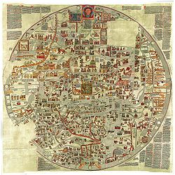
The map was found in a convent in Ebstorf
Ebstorf
Ebstorf is a municipality in the district of Uelzen, in Lower Saxony, Germany. It is situated approx. 12 km northwest of Uelzen, and 25 km south of Lüneburg....
, in northern Germany, in 1843. It is a very large map: painted on 30 goatskins sewn together, it measured around 3.6m x 3.6m. The head of Christ is depicted at the top of the map, with his hands on either side and his feet at the bottom. The Map is a greatly elaborated version of the common medieval tripartite or T and O map
T and O map
A T and O map or O-T or T-O map , is a type of medieval world map, sometimes also called a Beatine map or a Beatus map because one of the earliest known representations of this sort is attributed to Beatus of Liébana, an 8th-century Spanish monk...
, it is centered on Jerusalem with east on top of the map. It represents Rome
Rome
Rome is the capital of Italy and the country's largest and most populated city and comune, with over 2.7 million residents in . The city is located in the central-western portion of the Italian Peninsula, on the Tiber River within the Lazio region of Italy.Rome's history spans two and a half...
in the shape of a lion, and has an evident interest in the distribution of bishropics.
There is text around the map, which includes descriptions of animals, the creation of the world, definitions of terms, and a sketch of the more common T and O map
T and O map
A T and O map or O-T or T-O map , is a type of medieval world map, sometimes also called a Beatine map or a Beatus map because one of the earliest known representations of this sort is attributed to Beatus of Liébana, an 8th-century Spanish monk...
with an explanation of how the world is divided into three parts. The map incorporates pagan as well as Biblical history.
The arguments for Gervase of Tilbury
Gervase of Tilbury
Gervase of Tilbury or Gervasius Tilberiensis was a 13th century canon lawyer, statesman and writer, apparently born in either East Tilbury or West Tilbury, in Essex, England.-Life and works:...
being the mapmaker are based on the name Gervase, which was an uncommon name in Northern Germany at the time and on some similarities between the world view of the mapmaker and Gervase of Tilbury
Gervase of Tilbury
Gervase of Tilbury or Gervasius Tilberiensis was a 13th century canon lawyer, statesman and writer, apparently born in either East Tilbury or West Tilbury, in Essex, England.-Life and works:...
.
The editors of the Oxford Medieval Texts edition of Gervase of Tilbury
Gervase of Tilbury
Gervase of Tilbury or Gervasius Tilberiensis was a 13th century canon lawyer, statesman and writer, apparently born in either East Tilbury or West Tilbury, in Essex, England.-Life and works:...
's Otia Imperialia conclude that although them being the same man is an "attractive possibility", to accept it requires "too many improbable assumptions".
The original was destroyed in 1943, during the bombing of Hanover in World War II
World War II
World War II, or the Second World War , was a global conflict lasting from 1939 to 1945, involving most of the world's nations—including all of the great powers—eventually forming two opposing military alliances: the Allies and the Axis...
. There is a set of black and white photographs showing the original map, taken in 1891, and there are several colour copies of it made before it was destroyed.