
Earthquake scenario
Encyclopedia
Earthquake scenario is a planning tool to determine the appropriate emergency responses or building systems in seismic risk areas. It uses the basics of seismic hazard
studies, but usually places a set earthquake
on a specific fault, most likely near a high-population area. Most scenarios relate directly to urban seismic risk
, and seismic risk
in general.
Some earthquake scenarios follow some of the latest methodologies from the nuclear industry, namely a Seismic Margin Assessment (SMA) . In the process, a Review Level Earthquake (RLE) is chosen that challenges the system, has a reasonable probability, and is not totally overwhelming.
Scenarios have been developed for Seattle , New York City , and many of the faults in California
. In general, areas west of the Rockies use urban earthquakes of M7 (moment magnitude
), and eastern cities use an M6. Both types of earthquakes have about an equal chance of occurring in their respective areas, and both would cause equal disruption.
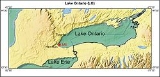
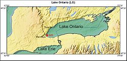 Some eastern cities do not have an earthquake scenario. As an example, the Greater Toronto area in Ontario, Canada has a local seismicity with about as much a chance for an M6 as most of the moderate earthquake zones of Eastern North America (ENA), including New York City. As seen on the map, the RLE would be an M6 located in the western end of Lake Ontario. It could be suspected that the damage would follow the New York City scenario, with extensive damage to lifelines, and brick buildings on soft ground.
Seismic hazard
Seismic hazard refers to the study of expected earthquake ground motions at the earth's surface, and its likely effects on existing natural conditions and man-made structures for public safety considerations; the results of such studies are published as seismic hazard maps, which identify the...
studies, but usually places a set earthquake
Earthquake
An earthquake is the result of a sudden release of energy in the Earth's crust that creates seismic waves. The seismicity, seismism or seismic activity of an area refers to the frequency, type and size of earthquakes experienced over a period of time...
on a specific fault, most likely near a high-population area. Most scenarios relate directly to urban seismic risk
Urban seismic risk
Urban seismic risk is a subset of the general term seismic risk which describes the problems specific to centers of population when they are subjected to earthquakes. Many risks can be minimised with good earthquake construction, and seismic analysis...
, and seismic risk
Seismic risk
Seismic risk uses the results of a seismic hazard analysis, and includes both consequence and probability. Seismic risk has been defined, for most management purposes, as the potential economic, social and environmental consequences of hazardous events that may occur in a specified period of time...
in general.
Some earthquake scenarios follow some of the latest methodologies from the nuclear industry, namely a Seismic Margin Assessment (SMA) . In the process, a Review Level Earthquake (RLE) is chosen that challenges the system, has a reasonable probability, and is not totally overwhelming.
Scenarios have been developed for Seattle , New York City , and many of the faults in California
California
California is a state located on the West Coast of the United States. It is by far the most populous U.S. state, and the third-largest by land area...
. In general, areas west of the Rockies use urban earthquakes of M7 (moment magnitude
Moment magnitude scale
The moment magnitude scale is used by seismologists to measure the size of earthquakes in terms of the energy released. The magnitude is based on the seismic moment of the earthquake, which is equal to the rigidity of the Earth multiplied by the average amount of slip on the fault and the size of...
), and eastern cities use an M6. Both types of earthquakes have about an equal chance of occurring in their respective areas, and both would cause equal disruption.