Earthquake location
Encyclopedia

Seismometer
Seismometers are instruments that measure motions of the ground, including those of seismic waves generated by earthquakes, volcanic eruptions, and other seismic sources...
is to locate the initiating points of earthquake
Earthquake
An earthquake is the result of a sudden release of energy in the Earth's crust that creates seismic waves. The seismicity, seismism or seismic activity of an area refers to the frequency, type and size of earthquakes experienced over a period of time...
epicenter
Epicenter
The epicenter or epicentre is the point on the Earth's surface that is directly above the hypocenter or focus, the point where an earthquake or underground explosion originates...
s. The secondary purpose, of determining the 'size' or Moment magnitude scale
Moment magnitude scale
The moment magnitude scale is used by seismologists to measure the size of earthquakes in terms of the energy released. The magnitude is based on the seismic moment of the earthquake, which is equal to the rigidity of the Earth multiplied by the average amount of slip on the fault and the size of...
must be calculated after the precise location is known.
The earliest seismographs were designed to give a sense of the direction of the first motions from an earthquake. The Chinese frog seismograph would have dropped its ball in the general compass direction of the earthquake, assuming a strong positive pulse. We now know that first motions can be in almost any direction depending on the type of initiating rupture (focal mechanism
Focal mechanism
The focal mechanism of an earthquake describes the inelastic deformation in the source region that generates the seismic waves. In the case of a fault-related event it refers to the orientation of the fault plane that slipped and the slip vector and is also known as a fault-plane solution...
).
The first refinement that allowed a more precise determination of the location, was the use of a time
Time
Time is a part of the measuring system used to sequence events, to compare the durations of events and the intervals between them, and to quantify rates of change such as the motions of objects....
scale. Instead of merely noting, or recording, the absolute motions of a pendulum
Pendulum
A pendulum is a weight suspended from a pivot so that it can swing freely. When a pendulum is displaced from its resting equilibrium position, it is subject to a restoring force due to gravity that will accelerate it back toward the equilibrium position...
, the displacement
Displacement (vector)
A displacement is the shortest distance from the initial to the final position of a point P. Thus, it is the length of an imaginary straight path, typically distinct from the path actually travelled by P...
s were plotted on a moving graph, driven by a clock
Clock
A clock is an instrument used to indicate, keep, and co-ordinate time. The word clock is derived ultimately from the Celtic words clagan and clocca meaning "bell". A silent instrument missing such a mechanism has traditionally been known as a timepiece...
mechanism. This was the first seismogram
Seismogram
A seismogram is a graph output by a seismograph. It is a record of the ground motion at a measuring station as a function of time. Seismograms typically record motions in three cartesian axes , with the z axis perpendicular to the Earth's surface and the x- and y- axes parallel to the surface...
, which allowed precise timing of the first ground motion, and an accurate plot of subsequent motions.
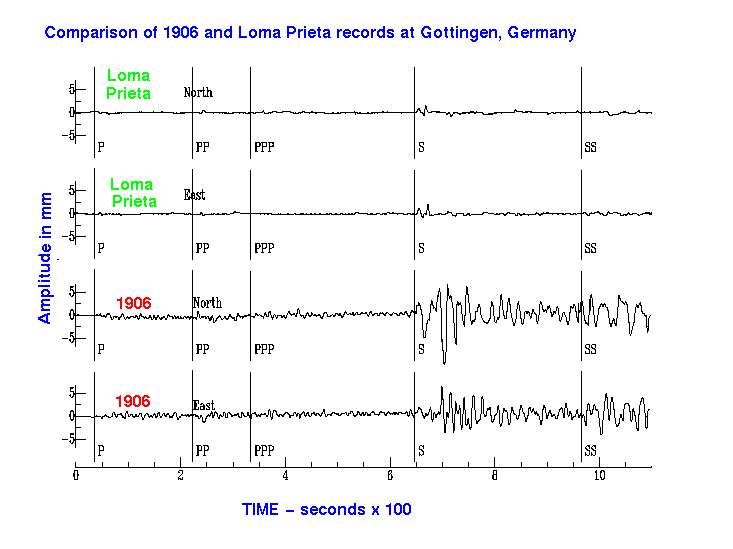
From the first seismograms, as seen on the figure, it was noticed that the trace was divided into two major portions. The first seismic wave to arrive was the P-wave
P-wave
P-waves are a type of elastic wave, also called seismic waves, that can travel through gases , solids and liquids, including the Earth. P-waves are produced by earthquakes and recorded by seismographs...
, followed closely by the S-wave
S-wave
A type of seismic wave, the S-wave, secondary wave, or shear wave is one of the two main types of elastic body waves, so named because they move through the body of an object, unlike surface waves....
. Knowing the relative 'velocities of propagation', it was a simple matter to calculate the distance of the earthquake.
One seismograph would give the distance, but that could be plotted as a circle, with an infinite number of possibilities. Two seismographs would give two intersecting circles, with two possible locations. Only with a third seismograph would there be a precise location.
The process of accurate location, was greatly improved with the advent of precise absolute timing. Early seismographs were almost always located at an astronomical observatory
Observatory
An observatory is a location used for observing terrestrial or celestial events. Astronomy, climatology/meteorology, geology, oceanography and volcanology are examples of disciplines for which observatories have been constructed...
, just for the purpose of timing. See the history of the Canadian Dominion Observatory
Dominion Observatory
The Dominion Observatory was an astronomical observatory in Ottawa, Canada that operated from 1902 to 1970. The Observatory was also an institution within the Canadian Federal Government. The observatory grew out of the Department of the Interior's need for the precise coordinates and timekeeping...
, is also the Geological Survey of Canada seismology laboratory. Recently, GPS
Global Positioning System
The Global Positioning System is a space-based global navigation satellite system that provides location and time information in all weather, anywhere on or near the Earth, where there is an unobstructed line of sight to four or more GPS satellites...
is being used for accurate time, and seismometers can be located almost anywhere.
Modern earthquake location still requires a minimum of three seismometers. Most likely, there are many, forming a seismic array. The emphasis is on precision, since much can be learned about the fault mechanics
Fault mechanics
Fault mechanics is a field of study that investigates the behavior of geologic faults.Behind every good earthquake is some weak rock. Whether the rock remains weak becomes an important point in determining the potential for bigger earthquakes....
and seismic hazard
Seismic hazard
Seismic hazard refers to the study of expected earthquake ground motions at the earth's surface, and its likely effects on existing natural conditions and man-made structures for public safety considerations; the results of such studies are published as seismic hazard maps, which identify the...
, if the locations can be determined to within a kilometer or two, for small earthquakes. For this, computer programs use an iterative process, involving a 'guess and correction' algorithm. As well, a very good model of the local crustal velocity structure is required: seismic velocities vary with the local geology. For P-waves, the relation between velocity and bulk density
Bulk density
Bulk density is a property of powders, granules and other "divided" solids, especially used in reference to mineral components , chemical substances, ingredients, foodstuff or any other masses of corpuscular or particulate matter. It is defined as the mass of many particles of the material...
of the medium has been quantified in Gardner's relation
Gardner's relation
Gardner's relation, or Gardner's equation, named after G. H. F. Gardner and L. W. Gardner, is an empirically derived equation that relates seismic P-wave velocity to the bulk density of the lithology in which the wave travels...
.

