
Dyer State Wayside
Encyclopedia
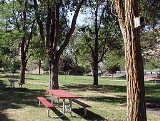
Dyer State Wayside, a rest stop with picnic tables and public toilets, lies about 10 miles (16.1 km) miles south of Condon
, along Oregon Route 19
. Named for J.W. Dyer, who gave the land to the state in 1931, it occupies 0.6 acres (2,428.1 m²) in a narrow canyon along a branch of Thirty Mile Creek at an elevation of 2438 feet (743.1 m).
In 1997, a group of volunteers called Dyer Partners renovated the park, which had become "an overgrown weed
patch with rotting picnic tables". They trimmed locust
trees, built fences, repaired picnic tables, and planted fruit trees. The federal Bureau of Land Management
donated two surplus toilets; the Oregon Parks and Recreation Department
built vaults for the toilets and installed an irrigation system, and Gilliam County
road crews made pathways and improved the parking lot.
Condon, Oregon
Condon is a city in Gilliam County, Oregon, United States. The population was 759 at the 2000 census. It is the county seat of Gilliam County. It is located on Oregon Route 19....
, along Oregon Route 19
Oregon Route 19
Oregon Route 19 is an Oregon state highway in the north-central part of the state. It runs from Interstate 84 at Arlington in the Columbia River Gorge to a junction with U.S. Route 26 in Grant County, near the Sheep Rock Unit of the John Day Fossil Beds National Monument. Oregon Route 19 is the...
. Named for J.W. Dyer, who gave the land to the state in 1931, it occupies 0.6 acres (2,428.1 m²) in a narrow canyon along a branch of Thirty Mile Creek at an elevation of 2438 feet (743.1 m).
In 1997, a group of volunteers called Dyer Partners renovated the park, which had become "an overgrown weed
patch with rotting picnic tables". They trimmed locust
trees, built fences, repaired picnic tables, and planted fruit trees. The federal Bureau of Land Management
Bureau of Land Management
The Bureau of Land Management is an agency within the United States Department of the Interior which administers America's public lands, totaling approximately , or one-eighth of the landmass of the country. The BLM also manages of subsurface mineral estate underlying federal, state and private...
donated two surplus toilets; the Oregon Parks and Recreation Department
Oregon Parks and Recreation Department
The Oregon Parks and Recreation Department , officially known as the State Parks and Recreation Department, is the government agency of the U.S. state of Oregon which operates its system of state parks...
built vaults for the toilets and installed an irrigation system, and Gilliam County
Gilliam County, Oregon
-Demographics:As of the census of 2000, there were 1,915 people, 819 households, and 543 families residing in the county. The population density was 2 people per square mile . There were 1,043 housing units at an average density of 1 per square mile...
road crews made pathways and improved the parking lot.