
Duder Regional Park
Encyclopedia

Auckland City
Auckland City was the city and local authority covering the Auckland isthmus and most of the islands of the Hauraki Gulf, in the North Island of New Zealand. On 1 November 2010 it was amalgamated into the wider Auckland Region under the authority of the new Auckland Council...
, New Zealand
New Zealand
New Zealand is an island country in the south-western Pacific Ocean comprising two main landmasses and numerous smaller islands. The country is situated some east of Australia across the Tasman Sea, and roughly south of the Pacific island nations of New Caledonia, Fiji, and Tonga...
.
History
The park was created in 1995 after the sale of the land by the Duder family to the Auckland Regional CouncilAuckland Regional Council
The Auckland Regional Council was the regional council of the Auckland Region. Its predecessor the Auckland Regional Authority was formed in 1963 and became the ARC in 1989...
. Prior to the sale the land had been farmed by descendants of Thomas Duder for about 130 years. The land was purchased in 1866 from the original Maori owners Ngai Tai
Ngai Tai
Ngāi Tai is a Māori tribal group in the area around Tōrere in the East Coast area of the North Island, New Zealand, and also at Clevedon near Auckland....
who had historically built a pa
Pa (Maori)
The word pā can refer to any Māori village or settlement, but in traditional use it referred to hillforts fortified with palisades and defensive terraces and also to fortified villages. They first came into being about 1450. They are located mainly in the North Island north of lake Taupo...
on the headland.
An extra 13.7 ha was added in 2010 to prevent coast development obstructing views from the park.
Description
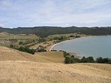
The park is a working farm bounded to the west by Duder's BeachDuder's Beach
Duders Beach is located in Manukau City, New Zealand, to the east of Maraetai on the North Road from Clevedon.The land was purchased in 1866 from the original Maori owners Ngai Tai by Thomas Duder...
. It is situated on a headland and offers commanding views of the Hauraki Gulf
Hauraki Gulf
The Hauraki Gulf is a coastal feature of the North Island of New Zealand. It has a total area of 4000 km², and lies between the Auckland Region, the Hauraki Plains, the Coromandel Peninsula and Great Barrier Island...
. There is limited native bush as most of the land is grassed. There are no designated picnic areas and facilities are limited.
Small numbers of the endangered tuturi whatu (New Zealand dotterel
New Zealand Dotterel
The New Zealand Dotterel, Red-breasted Plover, or New Zealand Plover is an endangered species found only in certain areas of New Zealand. Its Māori names include Tūturiwhatu, Pukunui, and Kūkuruatu...
) breed on shell banks south of the park. This area is not accessible to the public.
External links
- Auckland Regional Council Management plan - Gives descriptions of geology of Duder park, Waiheke and Hunua etc