
Don Juan Pond
Encyclopedia
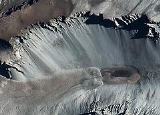
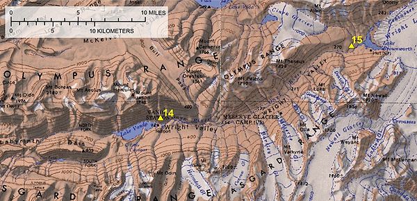
Don Juan Pond, also called Lake Don Juan, is a small and very shallow hypersaline lake in the west end of Wright Valley
(South Fork), Victoria Land
, Antarctica, 9 kilometres (5.6 mi) west from Lake Vanda
. It is wedged between the Asgard Range
in the south and the Dais
in the north. On the west end there is a small tributary and a feature that has been described as a rock glacier. Don Juan Pond is the saltiest body of water on earth with a salinity level of over 40%.
Don Juan Pond was discovered in 1961. It was named for two helicopter pilots, Lt Don Roe and Lt John Hickey, who piloted the helicopter involved with the first field party investigating the pond. On that initial investigation, the temperature was -30 C and the water remained in a liquid state.
than the Dead Sea
or even Lake Assal (Djibouti) (the same is true for Lake Vanda
and perhaps other lakes in the McMurdo Dry Valleys
). It has been claimed that the salinity in Don Juan Pond is over 18 times the ocean's salinity, compared to that of the Dead Sea at about 8 times that of the ocean. The fact that it is the only one of the Antarctic hypersaline lakes that almost never freezes is an indication of its top rank in salinity among the world's lakes.
The salinity is high enough that it doesn't freeze in winter. Therefore, unlike other lakes and ponds in the dry valleys, it has no ice cover. It has been described as a groundwater discharge zone. The dominant ions in solution are calcium and chloride. The area around Don Juan Pond is covered with sodium chloride and calcium chloride salts that have been precipitated as the water evaporated. Area and volume of Don Juan Pond varies over time. According to the USGS topo map published in 1977, the area was approximately 0.25 km² (61.8 acre), However, in recent years the size of the pond has shrunk considerably. The maximum depth in 1993–94 was described as "a foot deep" (1 feet (30.5 cm)). In January 1997, it was approximately 10 centimetres (3.9 in) deep; in December 1998 the pond was almost dry everywhere except for an area of a few tens of square meters. Most of the remaining water was in depressions around large boulders in the pond.
The calculated composition for its water is CaCl2 3.72 mol/kg and NaCl 0.50 mol/kg, at the temperature of -51.8°C.
That would be equivalent to 413 g of CaCl2 and 29 g of NaCl per kg of water.
Wright Valley
The Wright Valley is the central one of the three large Dry Valleys in the Transantarctic Mountains, located west of McMurdo Sound at approximately . Wright Valley contains the Onyx River, the largest river in Antarctica, Lake Brownworth, the origin of Onyx River, and Lake Vanda, which is fed by...
(South Fork), Victoria Land
Victoria Land
Victoria Land is a region of Antarctica bounded on the east by the Ross Ice Shelf and the Ross Sea and on the west by Oates Land and Wilkes Land. It was discovered by Captain James Clark Ross in January 1841 and named after the UK's Queen Victoria...
, Antarctica, 9 kilometres (5.6 mi) west from Lake Vanda
Lake Vanda
Lake Vanda is a lake in Wright Valley, Victoria Land, Ross Dependency, Antarctica. The lake is 5 km long and has a maximum depth of 69 m. On its shore, New Zealand maintained Vanda Station from 1968 to 1995...
. It is wedged between the Asgard Range
Asgard Range
The Asgard Range is a mountain range in Victoria Land, Antarctica. It dividies Wright Valley from Taylor Glacier and Taylor Valley, and was named by the Victoria University of Wellington Antarctic Expedition after Asgard, the home of the Norse gods....
in the south and the Dais
Dais
Dais is any raised platform located either in or outside of a room or enclosure, often for dignified occupancy, as at the front of a lecture hall or sanctuary....
in the north. On the west end there is a small tributary and a feature that has been described as a rock glacier. Don Juan Pond is the saltiest body of water on earth with a salinity level of over 40%.
Don Juan Pond was discovered in 1961. It was named for two helicopter pilots, Lt Don Roe and Lt John Hickey, who piloted the helicopter involved with the first field party investigating the pond. On that initial investigation, the temperature was -30 C and the water remained in a liquid state.
Salinity
Don Juan Pond is a shallow, flat-bottom, hyper-saline pond. It has greater salinitySalinity
Salinity is the saltiness or dissolved salt content of a body of water. It is a general term used to describe the levels of different salts such as sodium chloride, magnesium and calcium sulfates, and bicarbonates...
than the Dead Sea
Dead Sea
The Dead Sea , also called the Salt Sea, is a salt lake bordering Jordan to the east and Israel and the West Bank to the west. Its surface and shores are below sea level, the lowest elevation on the Earth's surface. The Dead Sea is deep, the deepest hypersaline lake in the world...
or even Lake Assal (Djibouti) (the same is true for Lake Vanda
Lake Vanda
Lake Vanda is a lake in Wright Valley, Victoria Land, Ross Dependency, Antarctica. The lake is 5 km long and has a maximum depth of 69 m. On its shore, New Zealand maintained Vanda Station from 1968 to 1995...
and perhaps other lakes in the McMurdo Dry Valleys
McMurdo Dry Valleys
The McMurdo Dry Valleys are a row of snow-free valleys in Antarctica located within Victoria Land west of McMurdo Sound. The region is one of the world's most extreme deserts, and includes many interesting features including Lake Vida and the Onyx River, Antarctica's longest river.-Climate:The Dry...
). It has been claimed that the salinity in Don Juan Pond is over 18 times the ocean's salinity, compared to that of the Dead Sea at about 8 times that of the ocean. The fact that it is the only one of the Antarctic hypersaline lakes that almost never freezes is an indication of its top rank in salinity among the world's lakes.
The salinity is high enough that it doesn't freeze in winter. Therefore, unlike other lakes and ponds in the dry valleys, it has no ice cover. It has been described as a groundwater discharge zone. The dominant ions in solution are calcium and chloride. The area around Don Juan Pond is covered with sodium chloride and calcium chloride salts that have been precipitated as the water evaporated. Area and volume of Don Juan Pond varies over time. According to the USGS topo map published in 1977, the area was approximately 0.25 km² (61.8 acre), However, in recent years the size of the pond has shrunk considerably. The maximum depth in 1993–94 was described as "a foot deep" (1 feet (30.5 cm)). In January 1997, it was approximately 10 centimetres (3.9 in) deep; in December 1998 the pond was almost dry everywhere except for an area of a few tens of square meters. Most of the remaining water was in depressions around large boulders in the pond.
The calculated composition for its water is CaCl2 3.72 mol/kg and NaCl 0.50 mol/kg, at the temperature of -51.8°C.
That would be equivalent to 413 g of CaCl2 and 29 g of NaCl per kg of water.
External links
- Great Zoom into Don Juan Pond, Antarctica
- McMurdo Dry Valleys MCM Lakes Data
- Don Juan Pond GigaPan picture