
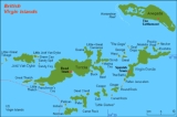
Districts of the British Virgin Islands
Encyclopedia
Administrative Districts
| Subdivision | Main town | Areakm² | Population(estimate 2006) |
|---|---|---|---|
| Anegada Anegada Anegada is the northernmost of the British Virgin Islands, a group of islands which form part of the archipelago of the Virgin Islands. It lies approximately north of Virgin Gorda. Anegada is the only inhabited British Virgin Island formed from coral and limestone, rather than being of volcanic... |
The Settlement | 38.6 | 204 |
| Jost Van Dyke Jost Van Dyke At roughly 8 square kilometers, and about 3 square miles Jost Van Dyke is the smallest of the four main islands of the British Virgin Islands, the northern portion of the archipelago of the Virgin Islands, located in the Atlantic Ocean and Caribbean Sea. Jost Van Dyke lies about 8 km to the... |
Great Harbour (Jost Van Dyke) | 8.3 | 176 |
| Tortola Tortola Tortola is the largest and most populated of the British Virgin Islands, a group of islands that form part of the archipelago of the Virgin Islands. Local tradition recounts that Christopher Columbus named it Tortola, meaning "land of the Turtle Dove". Columbus named the island Santa Ana... |
Road Town Road Town -See also:* Government House, the official residence of the Governor of the British Virgin Islands located in Road Town-External links:*****... |
59.2 | 16,630 |
| Virgin Gorda Virgin Gorda Virgin Gorda is the third-largest and second most populous of the British Virgin Islands . Located at approximately 18 degrees, 48 minutes North, and 64 degrees, 30 minutes West, it covers an area of about... |
Spanish Town Spanish Town, British Virgin Islands Spanish Town on southern Virgin Gorda is the second largest town on the British Virgin Islands. Also known as The Valley, Spanish Town offers numerous shopping possibilities featuring Mr. Nice Guy Store which is located in Spanish Town right across from the Virgin Gorda Yacht Harber... |
21.2 | 3,063 |
| Other Islands | Great Harbour (Peter Island Peter Island The 720 hectare Peter Island, is a private island located in the British Virgin Islands , about 5.2 miles south-west from Road Harbour , Tortola... ) |
23.7 | 181 |
| British Virgin Islands | Road Town Road Town -See also:* Government House, the official residence of the Governor of the British Virgin Islands located in Road Town-External links:*****... |
151.0 | 20,253 |
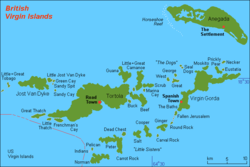
The "Other Islands" are mainly the islands south of Tortola (separated from it by the Sir Francis Drake Channel
Sir Francis Drake Channel
The Sir Francis Drake Channel is a strait in the British Virgin Islands separating the main island of Tortola from several smaller islands to the south....
and southwest of Virgin Gorda and detached Ginger Island
Ginger Island
Ginger Island is a presently uninhabited island of the British Virgin Islands in the Caribbean. It is one of the last undeveloped privately held islands in the Territory. It is the location of two of the better dive sites in the British Virgin Islands: "Alice in Wonderland" and "Ginger Steppes"...
, mainly Norman Island
Norman Island
Norman Island is located at the southern tip of the British Virgin Islands archipelago. It is reputed to be the inspiration for Robert Louis Stevenson's pirate novel Treasure Island.-History:...
, Peter Island
Peter Island
The 720 hectare Peter Island, is a private island located in the British Virgin Islands , about 5.2 miles south-west from Road Harbour , Tortola...
, Cooper Island
Cooper Island (British Virgin Islands)
The island lies adjacent to "wreck alley", a popular wreck diving site in the British Virgin Islands where a number of vessels have been deliberately sunk as dive sites. A local dive store near the beach club rents tanks to certified scuba divers.-External links:...
and Salt Island
Salt Island, British Virgin Islands
Salt Island is one of the islands of the archipelago of the British Virgin Islands located about 4.7 miles south east of Road Town, the main town on Tortola...
. These islands are also known under the informal name Little Sisters
Little Sisters
The Little Sisters is an informal name for a group of some of the smaller islands of the British Virgin Islands, south of Tortola and southwest of Virgin Gorda...
or Southern Islands.
Civil Registry Districts
There are six Civil RegistryCivil registry
Civil registration is the system by which a government records the vital events of its citizens and residents. The resulting repository or database is called civil register or registry, or population registry. The primary purpose of civil registration is to create legal documents that are used to...
Districts in the British Virgin Islands:
| Civil Registry District | Area |
|---|---|
| District A | Virgin Gorda Virgin Gorda Virgin Gorda is the third-largest and second most populous of the British Virgin Islands . Located at approximately 18 degrees, 48 minutes North, and 64 degrees, 30 minutes West, it covers an area of about... |
| District B | Anegada Anegada Anegada is the northernmost of the British Virgin Islands, a group of islands which form part of the archipelago of the Virgin Islands. It lies approximately north of Virgin Gorda. Anegada is the only inhabited British Virgin Island formed from coral and limestone, rather than being of volcanic... |
| District C | East End (Tortola Tortola Tortola is the largest and most populated of the British Virgin Islands, a group of islands that form part of the archipelago of the Virgin Islands. Local tradition recounts that Christopher Columbus named it Tortola, meaning "land of the Turtle Dove". Columbus named the island Santa Ana... ) |
| District D | Road Town Road Town -See also:* Government House, the official residence of the Governor of the British Virgin Islands located in Road Town-External links:*****... (Tortola Tortola Tortola is the largest and most populated of the British Virgin Islands, a group of islands that form part of the archipelago of the Virgin Islands. Local tradition recounts that Christopher Columbus named it Tortola, meaning "land of the Turtle Dove". Columbus named the island Santa Ana... ) |
| District E | West End (Tortola Tortola Tortola is the largest and most populated of the British Virgin Islands, a group of islands that form part of the archipelago of the Virgin Islands. Local tradition recounts that Christopher Columbus named it Tortola, meaning "land of the Turtle Dove". Columbus named the island Santa Ana... ) |
| District F | Jost Van Dyke Jost Van Dyke At roughly 8 square kilometers, and about 3 square miles Jost Van Dyke is the smallest of the four main islands of the British Virgin Islands, the northern portion of the archipelago of the Virgin Islands, located in the Atlantic Ocean and Caribbean Sea. Jost Van Dyke lies about 8 km to the... |
Civil Registry Districts C, D and E are subdivisions of the main island Tortola
Tortola
Tortola is the largest and most populated of the British Virgin Islands, a group of islands that form part of the archipelago of the Virgin Islands. Local tradition recounts that Christopher Columbus named it Tortola, meaning "land of the Turtle Dove". Columbus named the island Santa Ana...
.
Electoral Districts
- By the Constitution and Elections Ordinance 1954, which establishes a new Legislative Council with an elected majority, the presidency is divided into five districts. Road Town District (area of the capital) sent two members to the legislative council, the other districts one each.
- A new constitution of 1967 provided for seven electoral districts, with one representative per district.
- In 1977, the number of electoral districts was augmented to nine. Each electoral district sends a member to the Legislative Council, which has 13 seats (including four at large members).
| Electoral District | Area |
|---|---|
| First Electoral District | West End, Carrott Bay (Tortola Tortola Tortola is the largest and most populated of the British Virgin Islands, a group of islands that form part of the archipelago of the Virgin Islands. Local tradition recounts that Christopher Columbus named it Tortola, meaning "land of the Turtle Dove". Columbus named the island Santa Ana... ) |
| Second Electoral District | Meyers, Cane Garden Bay, Brewers Bay (Tortola Tortola Tortola is the largest and most populated of the British Virgin Islands, a group of islands that form part of the archipelago of the Virgin Islands. Local tradition recounts that Christopher Columbus named it Tortola, meaning "land of the Turtle Dove". Columbus named the island Santa Ana... ) and Jost Van Dyke Jost Van Dyke At roughly 8 square kilometers, and about 3 square miles Jost Van Dyke is the smallest of the four main islands of the British Virgin Islands, the northern portion of the archipelago of the Virgin Islands, located in the Atlantic Ocean and Caribbean Sea. Jost Van Dyke lies about 8 km to the... |
| Third Electoral District | Sea Cow's Bay and surroundings (Tortola Tortola Tortola is the largest and most populated of the British Virgin Islands, a group of islands that form part of the archipelago of the Virgin Islands. Local tradition recounts that Christopher Columbus named it Tortola, meaning "land of the Turtle Dove". Columbus named the island Santa Ana... ) |
| Fourth Electoral District | Road Town Road Town -See also:* Government House, the official residence of the Governor of the British Virgin Islands located in Road Town-External links:*****... and surroundings (Tortola Tortola Tortola is the largest and most populated of the British Virgin Islands, a group of islands that form part of the archipelago of the Virgin Islands. Local tradition recounts that Christopher Columbus named it Tortola, meaning "land of the Turtle Dove". Columbus named the island Santa Ana... ) |
| Fifth Electoral District | Huntum's Ghut and Long Trench (Tortola Tortola Tortola is the largest and most populated of the British Virgin Islands, a group of islands that form part of the archipelago of the Virgin Islands. Local tradition recounts that Christopher Columbus named it Tortola, meaning "land of the Turtle Dove". Columbus named the island Santa Ana... ) |
| Sixth Electoral District | Baugher's Bay and East Central Tortola |
| Seventh Electoral District | Long Look (Tortola Tortola Tortola is the largest and most populated of the British Virgin Islands, a group of islands that form part of the archipelago of the Virgin Islands. Local tradition recounts that Christopher Columbus named it Tortola, meaning "land of the Turtle Dove". Columbus named the island Santa Ana... ) and Beef Island Beef Island Beef Island is an island in the British Virgin Islands. It is located to the east of Tortola, and the two islands are connected by the Queen Elizabeth Bridge. Beef Island is the site of the Terrance B... |
| Eighth Electoral District | East End, Greenland and Hope Estate (Tortola Tortola Tortola is the largest and most populated of the British Virgin Islands, a group of islands that form part of the archipelago of the Virgin Islands. Local tradition recounts that Christopher Columbus named it Tortola, meaning "land of the Turtle Dove". Columbus named the island Santa Ana... ) |
| Ninth Electoral District | Virgin Gorda Virgin Gorda Virgin Gorda is the third-largest and second most populous of the British Virgin Islands . Located at approximately 18 degrees, 48 minutes North, and 64 degrees, 30 minutes West, it covers an area of about... and Anegada Anegada Anegada is the northernmost of the British Virgin Islands, a group of islands which form part of the archipelago of the Virgin Islands. It lies approximately north of Virgin Gorda. Anegada is the only inhabited British Virgin Island formed from coral and limestone, rather than being of volcanic... |