

Districts of Redditch
Encyclopedia
Redditch
is a town
and local government district
in north-east Worcestershire
, England
.
The town is divided into separate districts.
All street-name signs in Redditch have the street name in white lettering on a blue background and the district name in black lettering on a white background at the bottom of the sign. In the New Town areas the roads are usually named in alphabetical order and house numbering in the cul-de-sac closes is consecutive, starting with number 1 as the first house on the left as you enter, and the highest house number will be on the opposite side of the road as you leave.
Borough Council. They are;
has its ground (The Valley Stadium) in Batchley.
On 17 July 2008 a Batchley (Council) by-election was held. Here were there results;
Brenda Quinney (CON) 630 votes
Greg Chance (LAB) 539 votes
Maurice Field (BNP) 299 votes
Russel Taylor (LD) 121 votes
Orion Moon (IND) 25 votes
The district lends its name to Brockhill (HM Prison), a Young Offenders Institution at the Hewell Grange complex.
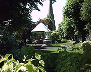 A commercial district and public space in the centre of Redditch, Church Green forms part of the town centre, however it is treated as a district and typically appears in addresses for buildings located there. Church Green forms a traditional centre for the town, like a village green or town square, and features a bandstand and fountain (see picture, right). Dominated by St Stephen's church, it is home to several banks, estate agents, charity shops, a Chinese restaurant and other businesses.
with North and South parts separated by Church Hill Way (a buses only road), with Church Hill Centre in the middle. Church Hill's geometric layout, a characteristic of planned new town developments, largely separates private (North) residents from social (South) residents in their day-to-day lives, whilst bringing together the children of both sides of the community at common schools (in particular, at Church Hill Middle School). Church Hill North previously had its own first school, known as Marfield Farm First School, however this has since been closed and demolished. It has been characterised by some as something of a social planning experiment..
The estate is named after St Leonards church and the hill it stands on slightly north of Church Hill at Beoley
.
is technically a separate village, but is still governed by Redditch Borough Council and counts as a district.
Feckenham village arose because it straddled the ancient saltway track between Alcester and Droitwich (later a Roman road, now the modern B4090 road), and the early stretches of the Bow Brook.
Feckenham Forest
once covered a substantial area of Worcestershire. It was used as a Norman royal hunting forest, and there was a royal hunting lodge near the village.
.
It still maintains the old village green, although it is now mostly a car park.
Keeping with the Redditch tradition of needle manufacture, Headless Cross once accommodated 3 needle works: the Needle Factory, located where Stonehouse Close is today; Phoenix Works on Birchfield Road and Mount Pleasant Mill on Evesham Road. A large brickworks
was situated on Marlpit Lane, as well as a smaller one along Birchfield Road.
There are 2 schools in Headless Cross: The Vaynor First School and Walkwood CE Middle School, both located on Feckenham Road.
Due to its slight altitude advantage, both of Redditch's water towers were built in Headless Cross. The old one still stands and has since been converted to a residential abode. The distinctive shape of the current water tower has become something of a local icon and can be seen dominating the skyline as far away as the Hollybush Inn.
Black Sabbath
's 1989
album Headless Cross
is named after this district.
. Ipsley is one of the few estates in the town to not have any Council owned housing. In common with Winyates Green, all homes in the Ipsley estate are privately owned.
Politically, Lodge Park is represented by two Redditch Councillors, they are;
Cllr Andrew Fry (Labour
)
Cllr Mark Shurmer (Labour)
The district takes its name from an ancient moated homestead which was founded by Monks and dates back to the 12th century. It is now a listed heritage site. The medieval homestead was inhabited by the Mohun family which is where the name "Moon's" Moat comes from (Mohun being an early name for Moon). The homestead was last in use in the 18th century, but by the end that century the Mohun's had died out. The homestead fell into disuse and became a ruin. What was left of the homestead was removed so that nothing visible now remains on the site.
The Moon's Moat site is believed to be haunted by the ghost of Lady Mohun who is said to appear on or near to the site on the eve of St Agnes (21 January). There is some folklore and history associated with the site concerning a suicide and a murder which may explain the ghost story.
Only a fifty minute walk from the town centre.
Politically, Park Farm comes under the Lodge Park ward represented by two Councillors from the Labour Party
.
 The primary commercial core of Redditch is the indoor shopping centre, the Kingfisher Centre. Designed like an out of town mall facility, with fully covered walkways and integrated multi-storey car park
s, the Kingfisher Centre was built in place of several established Redditch town centre streets. The walkways are named after these streets.
The centre, along with Church Green and municipal buildings such as the Borough Council, Redditch central library and FE College
are enclosed on three sides by the raised one-way, three-lane Redditch Ringway. Designed for access to the car parks, it illustrates the early roads for prosperity approach in new town design philosophy applied in the UK in the 1960s and 1980s.
, along with many smaller businesses. It is named after the Washford Mill, which is now a popular public house and restaurant. Though a Mill has stood on this shet since 1066 and it is mentioned in the Domesday Book
. A lot of the areas of Redditch been so.... Ipsley, Batchley, Feckenham and neighbouring Bordesley and beoley all been Saxon settlements.
Webheath is home to two first schools, located on Downsell road. They are:
Webheath is the final district to the West of the Redditch constituency. The constituency was created in 1997 were Labour's Jacqui Smith was elected until her defeat in 2010. Karen Lumley of the Conservative Party now represents Redditch in Westminster.
 Winyates is a new town estate in eastern Redditch. It comprises
West and East parts are separated by Winyates Way, a continuation of Church Hill Way and Matchborough Way. Winyates West adjoins Arrow Valley Park
, accessible by a footpath under Battens Drive.
Politically, Winyates has three Redditch Councillors;
Cllr Nigel Hicks (Liberal Democrats
)
Cllr Malcolm Hall (Liberal Democrats)
Cllr David Enderby (British National Party
)
Nigel Hicks & Malcolm Hall are 2 of 3 Liberal Democrat councillors on the Redditch borough council. David Enderby is the only BNP councillor on the Redditch council, he was the first BNP councillor to be elected in the whole of Worcestershire
.
Tenacres first school is located in Winyates East. Ipsley Middle School is located in Winyates West.
Redditch
Redditch is a town and local government district in north-east Worcestershire, England, approximately south of Birmingham. The district had a population of 79,216 in 2005. In the 19th century it became the international centre for the needle and fishing tackle industry...
is a town
Town
A town is a human settlement larger than a village but smaller than a city. The size a settlement must be in order to be called a "town" varies considerably in different parts of the world, so that, for example, many American "small towns" seem to British people to be no more than villages, while...
and local government district
Non-metropolitan district
Non-metropolitan districts, or colloquially shire districts, are a type of local government district in England. As created, they are sub-divisions of non-metropolitan counties in a so-called "two-tier" arrangement...
in north-east Worcestershire
Worcestershire
Worcestershire is a non-metropolitan county, established in antiquity, located in the West Midlands region of England. For Eurostat purposes it is a NUTS 3 region and is one of three counties that comprise the "Herefordshire, Worcestershire and Warwickshire" NUTS 2 region...
, England
England
England is a country that is part of the United Kingdom. It shares land borders with Scotland to the north and Wales to the west; the Irish Sea is to the north west, the Celtic Sea to the south west, with the North Sea to the east and the English Channel to the south separating it from continental...
.
The town is divided into separate districts.
All street-name signs in Redditch have the street name in white lettering on a blue background and the district name in black lettering on a white background at the bottom of the sign. In the New Town areas the roads are usually named in alphabetical order and house numbering in the cul-de-sac closes is consecutive, starting with number 1 as the first house on the left as you enter, and the highest house number will be on the opposite side of the road as you leave.
Abbeydale
Politically, Abbeydale is represented by two Councillors from the RedditchRedditch
Redditch is a town and local government district in north-east Worcestershire, England, approximately south of Birmingham. The district had a population of 79,216 in 2005. In the 19th century it became the international centre for the needle and fishing tackle industry...
Borough Council. They are;
- Cllr Diane Thomas (Liberal DemocratsLiberal DemocratsThe Liberal Democrats are a social liberal political party in the United Kingdom which supports constitutional and electoral reform, progressive taxation, wealth taxation, human rights laws, cultural liberalism, banking reform and civil liberties .The party was formed in 1988 by a merger of the...
) - Cllr Colin MacMillan (ConConservative Party (UK)The Conservative Party, formally the Conservative and Unionist Party, is a centre-right political party in the United Kingdom that adheres to the philosophies of conservatism and British unionism. It is the largest political party in the UK, and is currently the largest single party in the House...
)
Batchley
Redditch United F.C.Redditch United F.C.
Redditch United F.C. is an English football club based in Redditch, Worcestershire. The club are currently members of the Southern League Premier Division and play at the Valley.-Birmingham Combination:...
has its ground (The Valley Stadium) in Batchley.
On 17 July 2008 a Batchley (Council) by-election was held. Here were there results;
Brenda Quinney (CON) 630 votes
Greg Chance (LAB) 539 votes
Maurice Field (BNP) 299 votes
Russel Taylor (LD) 121 votes
Orion Moon (IND) 25 votes
Brockhill
Situated in the north west of the town. Almost entirely a residential area and home to many housing estates constructed in the last few years.The district lends its name to Brockhill (HM Prison), a Young Offenders Institution at the Hewell Grange complex.
Church Green
Church Hill
The largest estate in Redditch, occupying the north-east corner of the town, Church Hill Ward has yearly elections of Councillors due to its size and the number of councillors. The estate comprises Moons Moat, Marlfield Barn and Bomford Hill which boasts a Roman amphitheatre. Church Hill is divided into- Church Hill North - primarily private residential
- Church Hill Centre - a small commercial centre with a community centre and flats run by the YMCA, a medical centre, dentist, shops and a take-away, and first and middle schools.
- Church Hill South - primarily social housing
with North and South parts separated by Church Hill Way (a buses only road), with Church Hill Centre in the middle. Church Hill's geometric layout, a characteristic of planned new town developments, largely separates private (North) residents from social (South) residents in their day-to-day lives, whilst bringing together the children of both sides of the community at common schools (in particular, at Church Hill Middle School). Church Hill North previously had its own first school, known as Marfield Farm First School, however this has since been closed and demolished. It has been characterised by some as something of a social planning experiment..
The estate is named after St Leonards church and the hill it stands on slightly north of Church Hill at Beoley
Beoley
Beoley is a village and civil parish just north of Redditch in the Bromsgrove District of Worcestershire, and adjoins Warwickshire to the east. The 2001 census recorded a parish population of 945, most of whom live at Holt End...
.
Feckenham
FeckenhamFeckenham
Feckenham is a village and civil parish in the Borough of Redditch in Worcestershire, England. It lies some three miles south-west of the town of Redditch and is around twelve miles north-east of the ancient city of Worcester...
is technically a separate village, but is still governed by Redditch Borough Council and counts as a district.
Feckenham village arose because it straddled the ancient saltway track between Alcester and Droitwich (later a Roman road, now the modern B4090 road), and the early stretches of the Bow Brook.
Feckenham Forest
Feckenham Forest
Feckenham Forest was a royal forest, centred around the town of Feckenham, covering large parts of west Worcestershire and Warwickshire. As such, it was not entirely wooded, nor entirely the property of the King. Rather, the King had legal rights over game, wood and grazing within the forest, and...
once covered a substantial area of Worcestershire. It was used as a Norman royal hunting forest, and there was a royal hunting lodge near the village.
Headless Cross
Like Crabbs Cross, Headless Cross was once a village in its own right, it is thought to be named after Headless Cross farm, which was situated roughly where Vaynor Drive is today. Headless Cross may be derived from Smeethehedley, itself an indication of a role in Feckenham ForestFeckenham Forest
Feckenham Forest was a royal forest, centred around the town of Feckenham, covering large parts of west Worcestershire and Warwickshire. As such, it was not entirely wooded, nor entirely the property of the King. Rather, the King had legal rights over game, wood and grazing within the forest, and...
.
It still maintains the old village green, although it is now mostly a car park.
Keeping with the Redditch tradition of needle manufacture, Headless Cross once accommodated 3 needle works: the Needle Factory, located where Stonehouse Close is today; Phoenix Works on Birchfield Road and Mount Pleasant Mill on Evesham Road. A large brickworks
Brickworks
A brickworks also known as a brick factory, is a factory for the manufacturing of bricks, from clay or shale. Usually a brickworks is located on a clay bedrock often with a quarry for clay on site....
was situated on Marlpit Lane, as well as a smaller one along Birchfield Road.
There are 2 schools in Headless Cross: The Vaynor First School and Walkwood CE Middle School, both located on Feckenham Road.
Due to its slight altitude advantage, both of Redditch's water towers were built in Headless Cross. The old one still stands and has since been converted to a residential abode. The distinctive shape of the current water tower has become something of a local icon and can be seen dominating the skyline as far away as the Hollybush Inn.
Black Sabbath
Black Sabbath
Black Sabbath are an English heavy metal band, formed in Aston, Birmingham in 1969 by Ozzy Osbourne , Tony Iommi , Geezer Butler , and Bill Ward . The band has since experienced multiple line-up changes, with Tony Iommi the only constant presence in the band through the years. A total of 22...
's 1989
1989 in music
This is a list of notable events in music that took place in the year 1989.-Events:*January 14 – Paul McCartney releases Снова в СССР exclusively in the USSR...
album Headless Cross
Headless Cross
Headless Cross is the fourteenth album by heavy metal band Black Sabbath, released in April 1989.This is the band's second album to feature singer Tony Martin and the first to feature drummer Cozy Powell.-Album information:...
is named after this district.
Ipsley
Ipsley is home to the corporate headquarters of engineering firm GKNGKN
GKN plc is a multinational automotive and aerospace components company headquartered in Redditch, United Kingdom. The company was formerly known as Guest, Keen and Nettlefolds and can trace its origins back to 1759 and the birth of the Industrial Revolution.GKN is listed on the London Stock...
. Ipsley is one of the few estates in the town to not have any Council owned housing. In common with Winyates Green, all homes in the Ipsley estate are privately owned.
Lakeside
Lakeside is a largely industrial area of the town. Its location is within close proximity to the Arrow Valley Park. There is also a small housing estate.Lodge Park
Lodge Park is where St. Bede's Catholic Middle School is.Politically, Lodge Park is represented by two Redditch Councillors, they are;
Cllr Andrew Fry (Labour
Labour Party (UK)
The Labour Party is a centre-left democratic socialist party in the United Kingdom. It surpassed the Liberal Party in general elections during the early 1920s, forming minority governments under Ramsay MacDonald in 1924 and 1929-1931. The party was in a wartime coalition from 1940 to 1945, after...
)
Cllr Mark Shurmer (Labour)
Matchborough
Matchborough is a large district of Redditch. Its location lies between Winyates, Ipsley and Washford. Matchborough is the location of Arrow Vale High School and Matchborough First School. Matchborough consists of 2 areas, Matchborough East and Matchborough West, it also has a small shopping centre called Matchborugh Centre, similar to Church Hill and Winyates centres. Matchborough contains the areas most iconic feature, Matchborough Pond located near Arrow Vale High School.Moons Moat
The district of Moon's Moat is an industrial and business estate in the north east of Redditch between Church Hill and Winyates. Moon's Moat itself is located in Church Hill.The district takes its name from an ancient moated homestead which was founded by Monks and dates back to the 12th century. It is now a listed heritage site. The medieval homestead was inhabited by the Mohun family which is where the name "Moon's" Moat comes from (Mohun being an early name for Moon). The homestead was last in use in the 18th century, but by the end that century the Mohun's had died out. The homestead fell into disuse and became a ruin. What was left of the homestead was removed so that nothing visible now remains on the site.
The Moon's Moat site is believed to be haunted by the ghost of Lady Mohun who is said to appear on or near to the site on the eve of St Agnes (21 January). There is some folklore and history associated with the site concerning a suicide and a murder which may explain the ghost story.
Oakenshaw South
Was built in the 1980s and consists of ten small, quiet closes.Only a fifty minute walk from the town centre.
Park Farm
There is an Industrial Park in Park Farm. Park Farm is in the "Central Redditch" area.Politically, Park Farm comes under the Lodge Park ward represented by two Councillors from the Labour Party
Labour Party (UK)
The Labour Party is a centre-left democratic socialist party in the United Kingdom. It surpassed the Liberal Party in general elections during the early 1920s, forming minority governments under Ramsay MacDonald in 1924 and 1929-1931. The party was in a wartime coalition from 1940 to 1945, after...
.
Town Centre
Multi-storey car park
A multi-storey car-park is a building designed specifically to be for car parking and where there are a number of floors or levels on which parking takes place...
s, the Kingfisher Centre was built in place of several established Redditch town centre streets. The walkways are named after these streets.
The centre, along with Church Green and municipal buildings such as the Borough Council, Redditch central library and FE College
North East Worcestershire College
North East Worcestershire College is a general further education college with campuses at Slideslow Drive in Bromsgrove and Peakman Street, Albert Street and Fishing Line Road in Redditch, Worcestershire. The College also offers outreach courses in community and employer premises across...
are enclosed on three sides by the raised one-way, three-lane Redditch Ringway. Designed for access to the car parks, it illustrates the early roads for prosperity approach in new town design philosophy applied in the UK in the 1960s and 1980s.
Washford
Washford is primarily a modern industrial estate in south-east Redditch. It is home to the corporate headquarters of automotive and bicycle accessories retailer HalfordsHalfords
Halfords Group plc is a leading retailer of car parts, car enhancements and bicycles operating in the United Kingdom, Ireland, the Czech Republic and more recently in Poland, although it is currently pulling out of the latter two countries...
, along with many smaller businesses. It is named after the Washford Mill, which is now a popular public house and restaurant. Though a Mill has stood on this shet since 1066 and it is mentioned in the Domesday Book
Domesday Book
Domesday Book , now held at The National Archives, Kew, Richmond upon Thames in South West London, is the record of the great survey of much of England and parts of Wales completed in 1086...
. A lot of the areas of Redditch been so.... Ipsley, Batchley, Feckenham and neighbouring Bordesley and beoley all been Saxon settlements.
Webheath
Webheath is a district of Redditch, in Worcestershire, England. The district neighbours Batchley and the village of Callow Hill. It is also near Feckenham and Astwood Bank. Webheath used to be a village but has recently been swallowed up and now comes under the town of Redditch.Webheath is home to two first schools, located on Downsell road. They are:
- Webheath First School
- Mount Carmel Catholic First School
Politics
Webheath comes under the West ward on Redditch Borough Council. It is represented by two councillors, both from the Conservative party. Councillor Kath Banks and Councillor Michael Braley represent Webheath on a four year term.Webheath is the final district to the West of the Redditch constituency. The constituency was created in 1997 were Labour's Jacqui Smith was elected until her defeat in 2010. Karen Lumley of the Conservative Party now represents Redditch in Westminster.
Winyates
- Winyates West
- Winyates East
- Winyates Green, to the east of Winyates East
West and East parts are separated by Winyates Way, a continuation of Church Hill Way and Matchborough Way. Winyates West adjoins Arrow Valley Park
Arrow Valley Country Park
Arrow Valley Country Park is a country park on the River Arrow, at Redditch, Worcestershire, England....
, accessible by a footpath under Battens Drive.
Politically, Winyates has three Redditch Councillors;
Cllr Nigel Hicks (Liberal Democrats
Liberal Democrats
The Liberal Democrats are a social liberal political party in the United Kingdom which supports constitutional and electoral reform, progressive taxation, wealth taxation, human rights laws, cultural liberalism, banking reform and civil liberties .The party was formed in 1988 by a merger of the...
)
Cllr Malcolm Hall (Liberal Democrats)
Cllr David Enderby (British National Party
British National Party
The British National Party is a British far-right political party formed as a splinter group from the National Front by John Tyndall in 1982...
)
Nigel Hicks & Malcolm Hall are 2 of 3 Liberal Democrat councillors on the Redditch borough council. David Enderby is the only BNP councillor on the Redditch council, he was the first BNP councillor to be elected in the whole of Worcestershire
Worcestershire
Worcestershire is a non-metropolitan county, established in antiquity, located in the West Midlands region of England. For Eurostat purposes it is a NUTS 3 region and is one of three counties that comprise the "Herefordshire, Worcestershire and Warwickshire" NUTS 2 region...
.
Tenacres first school is located in Winyates East. Ipsley Middle School is located in Winyates West.