
.gif)
Devil's Gate (Wyoming)
Encyclopedia
Sweetwater River
Sweetwater River may refer to:*Sweetwater River , a river in San Diego County, California, USA*Sweetwater River , a river in Natrona County, Wyoming, USA...
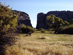
a few miles southwest of Independence Rock. The site, significant in the history of western pioneers
Mormon Pioneer
The Mormon pioneers were members of The Church of Jesus Christ of Latter-day Saints, also known as Latter-day Saints, who migrated across the United States from the Midwest to the Salt Lake Valley in what is today the U.S. state of Utah...
, was a major landmark on the Mormon Trail
Mormon Trail
The Mormon Trail or Mormon Pioneer Trail is the 1,300 mile route that members of The Church of Jesus Christ of Latter-day Saints traveled from 1846 to 1868...
and the Oregon Trail
Oregon Trail
The Oregon Trail is a historic east-west wagon route that connected the Missouri River to valleys in Oregon and locations in between.After 1840 steam-powered riverboats and steamboats traversing up and down the Ohio, Mississippi and Missouri rivers sped settlement and development in the flat...
although the actual routes of travel did not pass through the very narrow gorge. The earliest surviving photograph of this landmark was made in 1858 by Samuel C. Mills
Samuel C. Mills
A photographer from Washington, D.C., Samuel C. Mills produced the earliest surviving photographic record of the Oregon Trail and California Trail, from Fort Leavenworth, Kansas Territory, to Camp Floyd, Utah Territory.-Early years:...
, a photographer with the Captain Simpson Expedition
James H. Simpson
James Hervey Simpson was an officer in the U.S. Army and a member of the United States Topographical Engineers.-Early years:He was born in New Brunswick, New Jersey on March 9, 1813, the son of John Simpson and Mary Brunson. He graduated from the United States Military Academy in 1832 and was...
. It is accessible today from Wyoming Highway 220 (mile marker 57) between Casper
Casper, Wyoming
Casper is the county seat of Natrona County, Wyoming, United States.. Casper is the second-largest city in Wyoming , according to the 2010 census, with a population of 55,316...
and Muddy Gap, near the Mormon Handcart Historic Site and Martin's Cove
Martin's Cove
Martin's Cove is a historic site in Wyoming. The 933 acre cove is located 55 miles southwest of Casper, Wyoming, in Natrona County. It is located on the Mormon Trail and is also part of the North Platte-Sweetwater segment of the Oregon Trail...
.
Devil's Gate is a remarkable example of superposed or an antecedent drainage stream
Antecedent drainage stream
An antecedent stream or antecedent drainage is a stream that follows a course that formed before the tectonic uplift of the surrounding terrain and maintained its course through continuous downcutting of its valley. Also referred to as a "superposed stream."...
. The Sweetwater River cuts a narrow 100-meter deep slot through a granite ridge, yet had it flowed less than a kilometer to the south, it could have bypassed the ridge completely. The gorge was cut because the landscape was originally buried by valley fill sediments. The river cut downward and when it hit granite, kept on cutting. It was a matter of pure chance that the river hit the buried ridge where it did.
The site is accessible via semi-improved hiking trails from the Mormon Handcart Historical Center at the Sun Ranch
Tom Sun Ranch
Tom Sun Ranch, also known as Sun Ranch, is a historic site along the old Oregon Trail and Mormon Trail, about 6 mi west of Independence Rock, Wyoming on Wyoming Highway 220.-History:...
and from the old paved alignment of Wyoming Highway 220, approximately 60 miles from Casper and 12 miles northeast of Muddy Gap. It is on public land.