

Delaware Route 36
Encyclopedia
Delaware Route 36 is a state highway in Sussex County
, Delaware
. It runs in a generally northeast-southwest direction from Delaware Route 404 in Scotts Corner to Slaughter Beach
, a town along the Delaware Bay
. The road runs through the northern portion of Sussex County, passing through Greenwood
and Milford
. DE 36 was built as a state highway in stages during the 1920s and 1930s. The road was designated by 1938 from Delaware Route 16 east of Greenwood to Fort Saulsbury (present-day Slaughter Beach) and was extended west to DE 404 by 1994.
, Delaware Route 16 merges onto DE 36 and it assumes the name Hickman Road. The two routes continue into Greenwood, passing through the town on Market Street. On the eastern edge of Greenwood, it intersects U.S. Route 13
and it becomes the Beach Highway.
 In Saint Johnstown
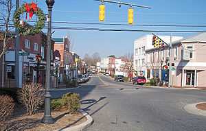
, Delaware Route 36 splits from DE 16 by heading to the northeast on Shawnee Road. It heads through countryside, and eventually reaches the city of Milford
. Upon reaching Milford, the road becomes Lakeview Avenue and intersects U.S. Route 113
. It heads northeast toward Silver Lake, a lake along the Mispillion River
, and DE 36 continues to the east on Causey Avenue. It then heads north on Walnut Street briefly before heading east on SE Front Street. It heads toward the eastern part of Milford where it intersects Delaware Route 1 Business (Rehoboth Boulevard).
DE 36 then heads to the northeast on Cedar Beach Road before angling to the east. It then intersects the Delaware Route 1 Milford Bypass at a diamond interchange
. DE 36 continues to the northeast on Cedar Beach Road toward Slaughter Beach
, where Delaware Route 36 ends at a drawbridge
over the Cedar Creek. The road continues past the drawbridge into Slaughter Beach where it becomes Bay Avenue and turns south and runs along the Delaware Bay
.
.
{| class=wikitable
!Location
!Mile
!Road
!Notes
|-
|Scotts Corner
|0.00
|
|Western terminus
|-
|rowspan=3|Greenwood
|3.60
|
|West end of DE 16 overlap
|-
|5.08
|
|
|-
|5.58
|
|East end of DE 16 overlap
|-
|rowspan=3|Milford
|15.85
|
|
|-
|17.56
|
|
|-
|
|
|Interchange
|-
|Slaughter Beach
|23.28
|Cedar Creek bridge
|Eastern terminus
|-
Sussex County, Delaware
Sussex County is a county located in the southern part of the U.S. state of Delaware. As of 2010 the population was 197,145, an increase of 25.9% over the previous decade. The county seat is Georgetown. The Seaford Micropolitan Statistical Area includes all of Sussex County.Sussex County is...
, Delaware
Delaware
Delaware is a U.S. state located on the Atlantic Coast in the Mid-Atlantic region of the United States. It is bordered to the south and west by Maryland, and to the north by Pennsylvania...
. It runs in a generally northeast-southwest direction from Delaware Route 404 in Scotts Corner to Slaughter Beach
Slaughter Beach, Delaware
As of the census of 2000, there were 198 people, 108 households, and 64 families residing in the town. The population density was 147.9 people per square mile . There were 253 housing units at an average density of 189.0 per square mile...
, a town along the Delaware Bay
Delaware Bay
Delaware Bay is a major estuary outlet of the Delaware River on the Northeast seaboard of the United States whose fresh water mixes for many miles with the waters of the Atlantic Ocean. It is in area. The bay is bordered by the State of New Jersey and the State of Delaware...
. The road runs through the northern portion of Sussex County, passing through Greenwood
Greenwood, Delaware
As of the census of 2000, there were 837 people, 335 households, and 211 families residing in the town. The population density was 1,267.2 people per square mile . There were 394 housing units at an average density of 596.5 per square mile...
and Milford
Milford, Delaware
Milford is a city in Kent and Sussex counties in the U.S. state of Delaware. According to the 2010 census, the population of the city is 9,559....
. DE 36 was built as a state highway in stages during the 1920s and 1930s. The road was designated by 1938 from Delaware Route 16 east of Greenwood to Fort Saulsbury (present-day Slaughter Beach) and was extended west to DE 404 by 1994.
Route description
Delaware Route 36 heads to the northeast from DE 404 on Scotts Store Road. West of GreenwoodGreenwood, Delaware
As of the census of 2000, there were 837 people, 335 households, and 211 families residing in the town. The population density was 1,267.2 people per square mile . There were 394 housing units at an average density of 596.5 per square mile...
, Delaware Route 16 merges onto DE 36 and it assumes the name Hickman Road. The two routes continue into Greenwood, passing through the town on Market Street. On the eastern edge of Greenwood, it intersects U.S. Route 13
U.S. Route 13
U.S. Route 13 is a north–south U.S. highway established in 1926 that runs for from Interstate 95 just north of Fayetteville, North Carolina to the northeastern suburbs of Philadelphia, Pennsylvania, in Morrisville. In all, it traverses five states in the Atlantic coastal plain region,...
and it becomes the Beach Highway.
Saint Johnstown, Delaware
Saint Johnstown, Delaware, USA was a stop on the now defunct Queen Anne's Railroad line between Ellendale and Greenwood. After the railroad closed down and the tracks were removed, all property owned by the railroad was returned to its previous landowners and several small towns built around the...
, Delaware Route 36 splits from DE 16 by heading to the northeast on Shawnee Road. It heads through countryside, and eventually reaches the city of Milford
Milford, Delaware
Milford is a city in Kent and Sussex counties in the U.S. state of Delaware. According to the 2010 census, the population of the city is 9,559....
. Upon reaching Milford, the road becomes Lakeview Avenue and intersects U.S. Route 113
U.S. Route 113
U.S. Route 113 is a spur of US 13 in the U.S. states of Maryland and Delaware. The U.S. Highway runs from US 13 in Pocomoke City, Maryland north to Delaware Route 1 in Milford, Delaware...
. It heads northeast toward Silver Lake, a lake along the Mispillion River
Mispillion River
The Mispillion River is a river flowing to Delaware Bay in southern Delaware in the United States. It is approximately 15 miles long and drains an area of 76 square miles on the Atlantic Coastal Plain....
, and DE 36 continues to the east on Causey Avenue. It then heads north on Walnut Street briefly before heading east on SE Front Street. It heads toward the eastern part of Milford where it intersects Delaware Route 1 Business (Rehoboth Boulevard).
DE 36 then heads to the northeast on Cedar Beach Road before angling to the east. It then intersects the Delaware Route 1 Milford Bypass at a diamond interchange
Diamond interchange
A diamond interchange is a common type of road junction, used where a freeway crosses a minor road. The freeway itself is grade-separated from the minor road, one crossing the other over a bridge...
. DE 36 continues to the northeast on Cedar Beach Road toward Slaughter Beach
Slaughter Beach, Delaware
As of the census of 2000, there were 198 people, 108 households, and 64 families residing in the town. The population density was 147.9 people per square mile . There were 253 housing units at an average density of 189.0 per square mile...
, where Delaware Route 36 ends at a drawbridge
Drawbridge
A drawbridge is a type of movable bridge typically associated with the entrance of a castle surrounded by a moat. The term is often used to describe all different types of movable bridges, like bascule bridges and lift bridges.-Castle drawbridges:...
over the Cedar Creek. The road continues past the drawbridge into Slaughter Beach where it becomes Bay Avenue and turns south and runs along the Delaware Bay
Delaware Bay
Delaware Bay is a major estuary outlet of the Delaware River on the Northeast seaboard of the United States whose fresh water mixes for many miles with the waters of the Atlantic Ocean. It is in area. The bay is bordered by the State of New Jersey and the State of Delaware...
.
History
By 1920, a section of present-day DE 36 southwest of Milford was completed as a state highway while a portion leading further northeast into Milford was under contract as one; the remainder of the route existed as an unimproved county road. The portion leading into Milford was completed by 1924, in addition to the segment of the road through Greenwood. By 1925, the state highway was under proposal between Greenwood and southwest of Milford. All of current DE 36 was completed by 1931 except for the easternmost part of the road. By 1938, DE 36 was designated to follow its current alignment between DE 16 east of Greenwood and Fort Saulsbury (now Slaughter Beach), with the entire route being paved except for the part near Fort Saulsbury. The unpaved portion was paved by 1939. By 1988, the portion of the current route west of Greenwood designated as Road 32. DE 36 was extended westward to its current terminus at DE 404 by 1994.Major intersections
The entire route is in Sussex CountySussex County, Delaware
Sussex County is a county located in the southern part of the U.S. state of Delaware. As of 2010 the population was 197,145, an increase of 25.9% over the previous decade. The county seat is Georgetown. The Seaford Micropolitan Statistical Area includes all of Sussex County.Sussex County is...
.
{| class=wikitable
!Location
!Mile
!Road
!Notes
|-
|Scotts Corner
|0.00
|
|Western terminus
|-
|rowspan=3|Greenwood
Greenwood, Delaware
As of the census of 2000, there were 837 people, 335 households, and 211 families residing in the town. The population density was 1,267.2 people per square mile . There were 394 housing units at an average density of 596.5 per square mile...
|3.60
|
|West end of DE 16 overlap
|-
|5.08
|
|
|-
|5.58
|
|East end of DE 16 overlap
|-
|rowspan=3|Milford
Milford, Delaware
Milford is a city in Kent and Sussex counties in the U.S. state of Delaware. According to the 2010 census, the population of the city is 9,559....
|15.85
|
|
|-
|17.56
|
|
|-
|
|
|Interchange
|-
|Slaughter Beach
Slaughter Beach, Delaware
As of the census of 2000, there were 198 people, 108 households, and 64 families residing in the town. The population density was 147.9 people per square mile . There were 253 housing units at an average density of 189.0 per square mile...
|23.28
|Cedar Creek bridge
|Eastern terminus
|-