
Dayville Historic District
Encyclopedia
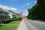
Dayville Historic District is a historic district
in the town of Killingly, Connecticut
, in the unincorporated community of Dayville.
The district was added to the National Register of Historic Places
in 1988.
The community or village of Dayville was named after Capt. John Day, who owned the water privileges on the Five Mile River
. With the opening of the Norwich and Worcester Railroad in 1830, Dayville also became a hub for freight transport for other manufacturing villages along the river. By 1849, the village had grown sufficiently in population to have its own church, the Dayville Congregational Church, a Greek revival building built by Alexander Blanchard. The church was heavily damaged in a hurricane in 1938.
Historic district (United States)
In the United States, a historic district is a group of buildings, properties, or sites that have been designated by one of several entities on different levels as historically or architecturally significant. Buildings, structures, objects and sites within a historic district are normally divided...
in the town of Killingly, Connecticut
Killingly, Connecticut
Killingly is a town in Windham County, Connecticut, United States. The population was 16,472 at the 2000 census. It consists of the borough of Danielson and the villages of Attawaugan, Ballouville, Dayville, East Killingly, Rogers, and South Killingly....
, in the unincorporated community of Dayville.
The district was added to the National Register of Historic Places
National Register of Historic Places
The National Register of Historic Places is the United States government's official list of districts, sites, buildings, structures, and objects deemed worthy of preservation...
in 1988.
The community or village of Dayville was named after Capt. John Day, who owned the water privileges on the Five Mile River
Five Mile River
The Five Mile River is a river approximately long, located in Connecticut's Northeast Corner. The original Nipmuc name was Assawaga, meaning "place between" or "halfway place." The Assawaga received its English name from the fact that the first land laid out upon it was "supposed to be about five...
. With the opening of the Norwich and Worcester Railroad in 1830, Dayville also became a hub for freight transport for other manufacturing villages along the river. By 1849, the village had grown sufficiently in population to have its own church, the Dayville Congregational Church, a Greek revival building built by Alexander Blanchard. The church was heavily damaged in a hurricane in 1938.