
Dayton, Alabama
Encyclopedia
Dayton is a town in Marengo County
, Alabama
, United States
. The population was 60 at the 2000 census.
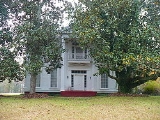
, oil mill, blacksmith shop, tavern, cabinet shop, drug store, and several general merchandise stores. The town also had several large homes, though most are now gone. One of the survivors, the William Poole House
, is listed on the National Register of Historic Places
. The decrease in agricultural activity over the last century has reduced the population to a fraction of what it once was.
of 2000, there were 60 people, 20 households, and 15 families residing in the town. The population density
was 60.1 people per square mile (23.2/km2). There were 28 housing units at an average density of 28.1 per square mile (10.8/km2). The racial makeup of the town was 65.00% Black
or African American
and 35.00% White
.
There were 20 households out of which 20.0% had children under the age of 18 living with them, 50.0% were married couples
living together, 20.0% had a female householder with no husband present, and 25.0% were non-families. 25.0% of all households were made up of individuals and 15.0% had someone living alone who was 65 years of age or older. The average household size was 3.00 and the average family size was 3.27.
In the town the population was spread out with 36.7% under the age of 18, 5.0% from 18 to 24, 13.3% from 25 to 44, 26.7% from 45 to 64, and 18.3% who were 65 years of age or older. The median age was 34 years. For every 100 females there were 76.5 males. For every 100 females age 18 and over, there were 58.3 males.
The median income for a household in the town was $12,500, and the median income for a family was $6,250. Males had a median income of $32,917 versus $30,417 for females. The per capita income
for the town was $10,235. There were 66.7% of families and 58.7% of the population living below the poverty line, including 50.0% of under eighteens and 50.0% of those over 64.
Marengo County, Alabama
Marengo County is a county of the U.S. state of Alabama. It is named in honor of a battlefield near Turin, Italy, where the French defeated the Austrians on June 14, 1800. As of 2010 the population was 21,027...
, Alabama
Alabama
Alabama is a state located in the southeastern region of the United States. It is bordered by Tennessee to the north, Georgia to the east, Florida and the Gulf of Mexico to the south, and Mississippi to the west. Alabama ranks 30th in total land area and ranks second in the size of its inland...
, United States
United States
The United States of America is a federal constitutional republic comprising fifty states and a federal district...
. The population was 60 at the 2000 census.
History
Dayton began to be settled in the early 19th century, with a town survey done and a "public well" established in 1832. The post office was established in 1837. It was incorporated on January 13, 1844. A devastating tornado hit the town in 1852. By 1860 the town had male and female academies, a hotel, cotton ginCotton gin
A cotton gin is a machine that quickly and easily separates cotton fibers from their seeds, a job formerly performed painstakingly by hand...
, oil mill, blacksmith shop, tavern, cabinet shop, drug store, and several general merchandise stores. The town also had several large homes, though most are now gone. One of the survivors, the William Poole House
William Poole House
The William Poole House, also known as the William Cade Thompson House, is a historic plantation house and historic district in Dayton, Alabama. The Greek Revival style house was completed in 1848...
, is listed on the National Register of Historic Places
National Register of Historic Places
The National Register of Historic Places is the United States government's official list of districts, sites, buildings, structures, and objects deemed worthy of preservation...
. The decrease in agricultural activity over the last century has reduced the population to a fraction of what it once was.
Geography
Dayton is located at 32°20′59"N 87°38′28"W (32.349733, -87.641247). According to the U.S. Census Bureau, the town has a total area of 1 square miles (2.6 km²), all of it land.Demographics
As of the censusCensus
A census is the procedure of systematically acquiring and recording information about the members of a given population. It is a regularly occurring and official count of a particular population. The term is used mostly in connection with national population and housing censuses; other common...
of 2000, there were 60 people, 20 households, and 15 families residing in the town. The population density
Population density
Population density is a measurement of population per unit area or unit volume. It is frequently applied to living organisms, and particularly to humans...
was 60.1 people per square mile (23.2/km2). There were 28 housing units at an average density of 28.1 per square mile (10.8/km2). The racial makeup of the town was 65.00% Black
Race (United States Census)
Race and ethnicity in the United States Census, as defined by the Federal Office of Management and Budget and the United States Census Bureau, are self-identification data items in which residents choose the race or races with which they most closely identify, and indicate whether or not they are...
or African American
Race (United States Census)
Race and ethnicity in the United States Census, as defined by the Federal Office of Management and Budget and the United States Census Bureau, are self-identification data items in which residents choose the race or races with which they most closely identify, and indicate whether or not they are...
and 35.00% White
Race (United States Census)
Race and ethnicity in the United States Census, as defined by the Federal Office of Management and Budget and the United States Census Bureau, are self-identification data items in which residents choose the race or races with which they most closely identify, and indicate whether or not they are...
.
There were 20 households out of which 20.0% had children under the age of 18 living with them, 50.0% were married couples
Marriage
Marriage is a social union or legal contract between people that creates kinship. It is an institution in which interpersonal relationships, usually intimate and sexual, are acknowledged in a variety of ways, depending on the culture or subculture in which it is found...
living together, 20.0% had a female householder with no husband present, and 25.0% were non-families. 25.0% of all households were made up of individuals and 15.0% had someone living alone who was 65 years of age or older. The average household size was 3.00 and the average family size was 3.27.
In the town the population was spread out with 36.7% under the age of 18, 5.0% from 18 to 24, 13.3% from 25 to 44, 26.7% from 45 to 64, and 18.3% who were 65 years of age or older. The median age was 34 years. For every 100 females there were 76.5 males. For every 100 females age 18 and over, there were 58.3 males.
The median income for a household in the town was $12,500, and the median income for a family was $6,250. Males had a median income of $32,917 versus $30,417 for females. The per capita income
Per capita income
Per capita income or income per person is a measure of mean income within an economic aggregate, such as a country or city. It is calculated by taking a measure of all sources of income in the aggregate and dividing it by the total population...
for the town was $10,235. There were 66.7% of families and 58.7% of the population living below the poverty line, including 50.0% of under eighteens and 50.0% of those over 64.