
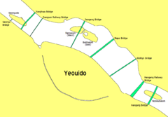
Dangsan Railway Bridge
Encyclopedia
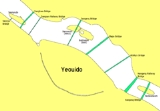
Han River (Korea)
The Han River is a major river in South Korea and the fourth longest river on the Korean peninsula after the Amnok, Duman, and Nakdong rivers. It is formed by the confluence of the Namhan River , which originates in Mount Daedeok, and the Bukhan River , which originates on the slopes of Mount...
in Seoul
Seoul
Seoul , officially the Seoul Special City, is the capital and largest metropolis of South Korea. A megacity with a population of over 10 million, it is the largest city proper in the OECD developed world...
. It is used exclusively by Seoul Subway Line 2
Seoul Subway Line 2
Seoul Subway Line 2 is a circular line of the Seoul Metropolitan Subway. The line running clockwise is called the "inner circle line" and the counter-clockwise line is called the "outer circle line." This is Seoul's most heavily used line, and the longest circular subway line in the world...
. Immediately on the south side of the bridge is Dangsan Station
Dangsan Station
Dangsan Station is an elevated station on the Seoul Subway Line 2. The station is located on the south bank of the Han River in Yeongdeungpo-gu. Because the station is elevated, trains exiting to or entering from the north make use of the Dangsan Railway Bridge. As of April 2009, the platform has...
in Yeongdeungpo-gu
Yeongdeungpo-gu
Yeongdeungpo-gu is an administrative district in southwest Seoul, South Korea. Although the origin of the name is uncertain, the first two syllables are thought to be from "yeongdeung" or "divine ascent", a shamanic rite. The third syllable is "po", representing water , referring to the...
, which is on an elevated platform. Hapjeong Station
Hapjeong Station
Hapjeong Station is a subterranean station of Seoul Subway Line 2 and Seoul Subway Line 6. The station is located just north of the Han River in Mapo-gu. The Line 2 platform has platform screen doors....
, a subterranean station in Mapo-gu
Mapo-gu
Mapo-gu is a gu, or district, within Seoul, South Korea. It lies northwest of the Han River. Several universities and government buildings are located here. Mapo is especially well-known for the Hongdae club district around Hongik University. Seoul Metropolitan Subway Line 1, Line 5, and Line 6...
, is located approximately 600 meters north of where the bridge makes landfall.
After the partial collapse of Seongsu Bridge
Seongsu Bridge
The Seongsu Bridge is a bridge over the Han River in Seoul, South Korea. The bridge links the Seongdong and Gangnam districts. The cantilever bridge was completed in 1979 and its total length is 1160 m. It became infamous when it collapsed on October 21, 1994....
, every bridge in Seoul was re-examined for safety and it was decided that Dangsan Bridge should be taken down and rebuilt. Amid considerable controversy, this bridge was closed for reconstruction on December 31st, 1996. The reconstruction finished on November 22nd, 1999.
See also
- List of Korea-related topics
- List of Han River bridges
- Seongsu BridgeSeongsu BridgeThe Seongsu Bridge is a bridge over the Han River in Seoul, South Korea. The bridge links the Seongdong and Gangnam districts. The cantilever bridge was completed in 1979 and its total length is 1160 m. It became infamous when it collapsed on October 21, 1994....