
Cyclone Cliff
Encyclopedia
Cyclone Cliff was the 14th Tropical Disturbance, 12th tropical depression and the sixth tropical cyclone
, as well as the last tropical disturbance, of the 2006–07 South Pacific cyclone season that formed west of 160E. Cliff was also the eighth tropical cyclone within the Southern Pacific Ocean as a whole. The Joint Typhoon Warning Center
also recognized Cliff as the 23rd Tropical Cyclone in the Southern Hemisphere
and the 10th within the South Pacific
.
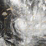
Cyclone Cliff formed as a tropical depression on April 3 to the northwest of Fiji. The next day after it had made landfall the depression was upgraded to tropical cyclone status and was named Cliff. Over the next few days Cliff gradually intensified in to a category two Cyclone on the Australian Tropical Cyclone Scale
whilst remaining at Tropical Storm status on the Saffir-Simpson Hurricane Scale
. As Cliff moved in to TCWC Wellington's area of responsibility Cliff started to show signs of starting its extra tropical transition so as a result TCWC Wellington issued their final advisory on April 6 on former tropical cyclone Cliff. Cyclone Cliff was responsible for one death. In the wake of the storm, an outbreak of typhoid and leptospirosis
infected 99 people and killed three across Fiji.
started to issue Special Weather Bulletins for Fiji on Tropical Depression 14F. This bulletin contained a Tropical Cyclone Alert for Vanua Levu
, Taveuni
as well as the Northern Lau Islands
. Later that day RSMC Nadi upgraded these alerts to a Cyclone Gale Warning for Eastern Vanua Levu
, Taveuni
, Naitaubu
, Yacata
, Kanacea
, Vanua Balavu
as well as Vatu Vara
. The next day RSMC Nadi canceled these warnings as Cliff moved further away from Fiji.
started to issue Special Weather Bulletins for Tonga on Tropical Cyclone Cliff. This Bulletin contained a Tropical Cyclone Alert for Tongatapu
and Eua Island
with a Strong wind warning in force for the rest of central Tonga
. Early the next day RSMC Nadi upgraded these Alerts to Cyclone Gale Warnings for Tongatapu
and Eua Island
with a Strong wind warning in force for the rest of central Tonga
. RSMC Nadi then stopped issuing these warnings the next day as Cliff moved away from Tonga.
in the eastern part of Vanua Levu
. However the 30 Students inside the school at the time all escaped any serious injuries as they fled to safety.
Cyclone Cliff was also responsible for flooded roads, minor damage to buildings as well as cut water supplies in eastern parts of Vanua Levu as well as on Taveuni Island. The people of Taveuni reported the loss of unaccountable acres of crops as the developing cyclone passed close to the island. Extensive damage was also reported in other parts of the Fijian Archpeigo including damaged crops & Trees as well as roofs being damaged. Cyclone Cliff was also indirectly responsible for one death in Fiji when a woman was swept from a flooded bridge. It is not known how much damage Cyclone Cliff caused.
experienced a power failure on April 4 at 2200 UTC. The standby power could not be restored so therefore operations were shifted to the National Emergency Operations Centre in Nukuʻalofa
which is the back up for the Met Service. The National Emergency Operations Centre continued to issue cyclone warnings until the threat posed by Cliff had passed. This was despite the met service being able to continue to operate on a mobile generator.
put a request forward to the World Meteorological Organization
s, RA V Tropical Cyclone Committee to have the name Cliff retired. This request was accepted with the name being replaced by Chip.
Tropical cyclone
A tropical cyclone is a storm system characterized by a large low-pressure center and numerous thunderstorms that produce strong winds and heavy rain. Tropical cyclones strengthen when water evaporated from the ocean is released as the saturated air rises, resulting in condensation of water vapor...
, as well as the last tropical disturbance, of the 2006–07 South Pacific cyclone season that formed west of 160E. Cliff was also the eighth tropical cyclone within the Southern Pacific Ocean as a whole. The Joint Typhoon Warning Center
Joint Typhoon Warning Center
The Joint Typhoon Warning Center is a joint United States Navy – United States Air Force task force located at the Naval Maritime Forecast Center in Pearl Harbor, Hawaii...
also recognized Cliff as the 23rd Tropical Cyclone in the Southern Hemisphere
Southern Hemisphere
The Southern Hemisphere is the part of Earth that lies south of the equator. The word hemisphere literally means 'half ball' or "half sphere"...
and the 10th within the South Pacific
Pacific Ocean
The Pacific Ocean is the largest of the Earth's oceanic divisions. It extends from the Arctic in the north to the Southern Ocean in the south, bounded by Asia and Australia in the west, and the Americas in the east.At 165.2 million square kilometres in area, this largest division of the World...
.
Cyclone Cliff formed as a tropical depression on April 3 to the northwest of Fiji. The next day after it had made landfall the depression was upgraded to tropical cyclone status and was named Cliff. Over the next few days Cliff gradually intensified in to a category two Cyclone on the Australian Tropical Cyclone Scale
Tropical cyclone scales
Tropical systems are officially ranked on one of several tropical cyclone scales according to their maximum sustained winds and in what oceanic basin they are located...
whilst remaining at Tropical Storm status on the Saffir-Simpson Hurricane Scale
Saffir-Simpson Hurricane Scale
The Saffir–Simpson Hurricane Scale , or the Saffir–Simpson Hurricane Wind Scale , classifies hurricanes — Western Hemisphere tropical cyclones that exceed the intensities of tropical depressions and tropical storms — into five categories distinguished by the intensities of their sustained winds...
. As Cliff moved in to TCWC Wellington's area of responsibility Cliff started to show signs of starting its extra tropical transition so as a result TCWC Wellington issued their final advisory on April 6 on former tropical cyclone Cliff. Cyclone Cliff was responsible for one death. In the wake of the storm, an outbreak of typhoid and leptospirosis
Leptospirosis
Leptospirosis is caused by infection with bacteria of the genus Leptospira, and affects humans as well as other mammals, birds, amphibians, and reptiles.The...
infected 99 people and killed three across Fiji.
Meteorological history
Early on April 1, 2007 RSMC Nadi reported that a tropical disturbance had formed about 210 km (130 mi) to the southwest of Rotuma. Over the next few days the disturbance remained weak as it moved towards the southwest before it was designated as Tropical Depression 14F early on February 3 despite the system being sheared with convection displaced from the low level circulation center.Fiji
Early on April 4 RSMC NadiFiji Meteorological Service
The Fiji Meteorological Service is a Department of the government of Fiji responsible for providing weather forecasts and is based in Nadi. Since 1995, FMS has been responsible for naming and tracking tropical cyclones in the Southwest Pacific region...
started to issue Special Weather Bulletins for Fiji on Tropical Depression 14F. This bulletin contained a Tropical Cyclone Alert for Vanua Levu
Vanua Levu
Vanua Levu , formerly known as Sandalwood Island, is the second largest island of Fiji. Located 64 kilometres to the north of the larger Viti Levu, the island has an area of 5,587.1 km² and a population of some 130,000.- Geography :...
, Taveuni
Taveuni
Taveuni is the third-largest island in Fiji, after Vanua Levu and Viti Levu, with a total land area of 435 square kilometers . The cigar-shaped island, a massive shield volcano which rises from the floor of the Pacific Ocean, is situated 6.5 kilometers to the east of Vanua Levu, across the...
as well as the Northern Lau Islands
Lau Islands
The Lau Islands of Fiji are situated in the southern Pacific Ocean, just east of the Koro Sea. Of this chain of about one hundred islands and islets, about thirty are inhabited...
. Later that day RSMC Nadi upgraded these alerts to a Cyclone Gale Warning for Eastern Vanua Levu
Vanua Levu
Vanua Levu , formerly known as Sandalwood Island, is the second largest island of Fiji. Located 64 kilometres to the north of the larger Viti Levu, the island has an area of 5,587.1 km² and a population of some 130,000.- Geography :...
, Taveuni
Taveuni
Taveuni is the third-largest island in Fiji, after Vanua Levu and Viti Levu, with a total land area of 435 square kilometers . The cigar-shaped island, a massive shield volcano which rises from the floor of the Pacific Ocean, is situated 6.5 kilometers to the east of Vanua Levu, across the...
, Naitaubu
Fiji
Fiji , officially the Republic of Fiji , is an island nation in Melanesia in the South Pacific Ocean about northeast of New Zealand's North Island...
, Yacata
Fiji
Fiji , officially the Republic of Fiji , is an island nation in Melanesia in the South Pacific Ocean about northeast of New Zealand's North Island...
, Kanacea
Kanacea
Kanacea is a volcanic island with seven peaks in Fiji's Lau archipelago. It is situated at 17.25° South and 179.171° East, 15 kilometers west of Vanua Balavu...
, Vanua Balavu
Vanua Balavu
Vanua Balavu is the second largest island in Fiji's Lau archipelago , and the main island of the Northern Lau Group.-Geography and infrastructure:...
as well as Vatu Vara
Vatu Vara
Vatu Vara Island lies in the northwest sector of Fiji's northern Lau Group of islands, 32 km west of Mago Island and some 60 km south-west of Vanua Balavu at Lat: 17° 26'00 S Long: 179° 31'00 W....
. The next day RSMC Nadi canceled these warnings as Cliff moved further away from Fiji.
Tonga
Late on April 4 RSMC NadiFiji Meteorological Service
The Fiji Meteorological Service is a Department of the government of Fiji responsible for providing weather forecasts and is based in Nadi. Since 1995, FMS has been responsible for naming and tracking tropical cyclones in the Southwest Pacific region...
started to issue Special Weather Bulletins for Tonga on Tropical Cyclone Cliff. This Bulletin contained a Tropical Cyclone Alert for Tongatapu
Tongatapu
Tongatapu is the main island of the Kingdom of Tonga and the location of its capital Nukualofa. It is located in Tonga's southern island group, to which it gives its name, and is the country's most populous island, with approximately 71,260 residents , 70.5% of the national population...
and Eua Island
Tonga
Tonga, officially the Kingdom of Tonga , is a state and an archipelago in the South Pacific Ocean, comprising 176 islands scattered over of ocean in the South Pacific...
with a Strong wind warning in force for the rest of central Tonga
Tonga
Tonga, officially the Kingdom of Tonga , is a state and an archipelago in the South Pacific Ocean, comprising 176 islands scattered over of ocean in the South Pacific...
. Early the next day RSMC Nadi upgraded these Alerts to Cyclone Gale Warnings for Tongatapu
Tongatapu
Tongatapu is the main island of the Kingdom of Tonga and the location of its capital Nukualofa. It is located in Tonga's southern island group, to which it gives its name, and is the country's most populous island, with approximately 71,260 residents , 70.5% of the national population...
and Eua Island
Tonga
Tonga, officially the Kingdom of Tonga , is a state and an archipelago in the South Pacific Ocean, comprising 176 islands scattered over of ocean in the South Pacific...
with a Strong wind warning in force for the rest of central Tonga
Tonga
Tonga, officially the Kingdom of Tonga , is a state and an archipelago in the South Pacific Ocean, comprising 176 islands scattered over of ocean in the South Pacific...
. RSMC Nadi then stopped issuing these warnings the next day as Cliff moved away from Tonga.
Fiji
Cyclone Cliff’s main impact on Fiji was to bring further flooding to the northern parts of Fiji which had been flooded 3 times during the cyclone season already. Cyclone Cliff was also responsible for a landslide which crashed in to a Primary School near Udu PointFiji
Fiji , officially the Republic of Fiji , is an island nation in Melanesia in the South Pacific Ocean about northeast of New Zealand's North Island...
in the eastern part of Vanua Levu
Vanua Levu
Vanua Levu , formerly known as Sandalwood Island, is the second largest island of Fiji. Located 64 kilometres to the north of the larger Viti Levu, the island has an area of 5,587.1 km² and a population of some 130,000.- Geography :...
. However the 30 Students inside the school at the time all escaped any serious injuries as they fled to safety.
Cyclone Cliff was also responsible for flooded roads, minor damage to buildings as well as cut water supplies in eastern parts of Vanua Levu as well as on Taveuni Island. The people of Taveuni reported the loss of unaccountable acres of crops as the developing cyclone passed close to the island. Extensive damage was also reported in other parts of the Fijian Archpeigo including damaged crops & Trees as well as roofs being damaged. Cyclone Cliff was also indirectly responsible for one death in Fiji when a woman was swept from a flooded bridge. It is not known how much damage Cyclone Cliff caused.
Tonga
There was no damage reported in Southern Tonga. However the Tonga's Meteorological Service based in Fua’amotuTonga
Tonga, officially the Kingdom of Tonga , is a state and an archipelago in the South Pacific Ocean, comprising 176 islands scattered over of ocean in the South Pacific...
experienced a power failure on April 4 at 2200 UTC. The standby power could not be restored so therefore operations were shifted to the National Emergency Operations Centre in Nukuʻalofa
Nukuʻalofa
Nukualofa is the capital of the Kingdom of Tonga. It is located on the north coast of the island of Tongatapu, in the southern most island group of Tonga.-Mythological origins:...
which is the back up for the Met Service. The National Emergency Operations Centre continued to issue cyclone warnings until the threat posed by Cliff had passed. This was despite the met service being able to continue to operate on a mobile generator.
Retirement
During 2008 RSMC NadiFiji Meteorological Service
The Fiji Meteorological Service is a Department of the government of Fiji responsible for providing weather forecasts and is based in Nadi. Since 1995, FMS has been responsible for naming and tracking tropical cyclones in the Southwest Pacific region...
put a request forward to the World Meteorological Organization
World Meteorological Organization
The World Meteorological Organization is an intergovernmental organization with a membership of 189 Member States and Territories. It originated from the International Meteorological Organization , which was founded in 1873...
s, RA V Tropical Cyclone Committee to have the name Cliff retired. This request was accepted with the name being replaced by Chip.
See also
- List of Southern Hemisphere tropical cyclone seasons
- 2006–07 South Pacific cyclone season