Cumulonimbus calvus
Encyclopedia
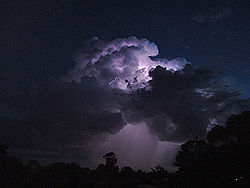
Cumulonimbus calvus is a moderately tall cumulonimbus cloud
which is capable of precipitation
, but has not yet reached the height where it forms into a cumulonimbus capillatus (fibrous-top) or cumulonimbus incus
(anvil-top). Cumulonimbus calvus develops from cumulus congestus, and its further development under auspicious conditions will result in cumulonimbus capillatus.
This cloud consists mainly of water droplets. By definition of cumulonimbus cloud
, at its top water droplets are transformed into ice crystals, but for cumulonimbus calvus content of ice crystals is small and freezing is in early stage, so cloud top still looks round and puffy.
Cumulonimbus calvus is characterized by distinctive (between other types of cumulonimbus cloud
) rounded shape and relatively sharp edges of its top area, unlike cumulonimbus incus
or cumulonimbus capillatus, which have cirriform tops. Developing cumulonimbus calvus loses sharp outlines of the top as more water droplets transform into ice crystals. Strong updrafts may form pileus
or thin vertical stripes protruding upwards out of the cloud. When upper part of the cloud freezes to greater extent and clearly visible cirriforms appears, cumulonimbus calvus turns into another species of cumulonimbus.
Cumulonimbus calvus arcus is a sub-type of cumulonimbus calvus, which has arcus cloud
ahead of cloud's front.

Cumulonimbus cloud
Cumulonimbus is a towering vertical cloud that is very tall, dense, and involved in thunderstorms and other inclement weather. Cumulonimbus originates from Latin: Cumulus "Heap" and nimbus "rain". It is a result of atmospheric instability. These clouds can form alone, in clusters, or along a cold...
which is capable of precipitation
Precipitation (meteorology)
In meteorology, precipitation In meteorology, precipitation In meteorology, precipitation (also known as one of the classes of hydrometeors, which are atmospheric water phenomena is any product of the condensation of atmospheric water vapor that falls under gravity. The main forms of precipitation...
, but has not yet reached the height where it forms into a cumulonimbus capillatus (fibrous-top) or cumulonimbus incus
Cumulonimbus incus
A cumulonimbus incus is a cumulonimbus cloud which has reached the level of stratospheric stability and has formed the characteristic flat, anvil-top shape...
(anvil-top). Cumulonimbus calvus develops from cumulus congestus, and its further development under auspicious conditions will result in cumulonimbus capillatus.
This cloud consists mainly of water droplets. By definition of cumulonimbus cloud
Cumulonimbus cloud
Cumulonimbus is a towering vertical cloud that is very tall, dense, and involved in thunderstorms and other inclement weather. Cumulonimbus originates from Latin: Cumulus "Heap" and nimbus "rain". It is a result of atmospheric instability. These clouds can form alone, in clusters, or along a cold...
, at its top water droplets are transformed into ice crystals, but for cumulonimbus calvus content of ice crystals is small and freezing is in early stage, so cloud top still looks round and puffy.
Cumulonimbus calvus is characterized by distinctive (between other types of cumulonimbus cloud
Cumulonimbus cloud
Cumulonimbus is a towering vertical cloud that is very tall, dense, and involved in thunderstorms and other inclement weather. Cumulonimbus originates from Latin: Cumulus "Heap" and nimbus "rain". It is a result of atmospheric instability. These clouds can form alone, in clusters, or along a cold...
) rounded shape and relatively sharp edges of its top area, unlike cumulonimbus incus
Cumulonimbus incus
A cumulonimbus incus is a cumulonimbus cloud which has reached the level of stratospheric stability and has formed the characteristic flat, anvil-top shape...
or cumulonimbus capillatus, which have cirriform tops. Developing cumulonimbus calvus loses sharp outlines of the top as more water droplets transform into ice crystals. Strong updrafts may form pileus
Pileus (meteorology)
A pileus , also called scarf cloud or cap cloud, is a small, horizontal cloud that can appear above a cumulus or cumulonimbus cloud, giving the parent cloud a characteristic "hoodlike" appearance. Pilei tend to change shape rapidly. They are formed by strong updrafts acting upon moist air at lower...
or thin vertical stripes protruding upwards out of the cloud. When upper part of the cloud freezes to greater extent and clearly visible cirriforms appears, cumulonimbus calvus turns into another species of cumulonimbus.
Cumulonimbus calvus arcus is a sub-type of cumulonimbus calvus, which has arcus cloud
Arcus cloud
An arcus cloud is a low, horizontal cloud formation. Roll clouds and shelf clouds are the two types of arcus clouds. A shelf cloud is usually associated with the leading edge of thunderstorm outflow; roll clouds are usually formed by outflows of cold air from sea breezes or cold fronts in the...
ahead of cloud's front.
Hazards
- LightningLightningLightning is an atmospheric electrostatic discharge accompanied by thunder, which typically occurs during thunderstorms, and sometimes during volcanic eruptions or dust storms...
; these clouds produce thunderstorms.
- WindWindWind is the flow of gases on a large scale. On Earth, wind consists of the bulk movement of air. In outer space, solar wind is the movement of gases or charged particles from the sun through space, while planetary wind is the outgassing of light chemical elements from a planet's atmosphere into space...
; these clouds may produce strong winds especially during a downburstDownburstA downburst is created by an area of significantly rain-cooled air that, after reaching ground level, spreads out in all directions producing strong winds. Unlike winds in a tornado, winds in a downburst are directed outwards from the point where it hits land or water...
- Further development; these clouds can become more powerful stormclouds.


