Crooked River (Missouri)
Encyclopedia

Tributary
A tributary or affluent is a stream or river that flows into a main stem river or a lake. A tributary does not flow directly into a sea or ocean...
of the Missouri River
Missouri River
The Missouri River flows through the central United States, and is a tributary of the Mississippi River. It is the longest river in North America and drains the third largest area, though only the thirteenth largest by discharge. The Missouri's watershed encompasses most of the American Great...
in west-central Missouri
Missouri
Missouri is a US state located in the Midwestern United States, bordered by Iowa, Illinois, Kentucky, Tennessee, Arkansas, Oklahoma, Kansas and Nebraska. With a 2010 population of 5,988,927, Missouri is the 18th most populous state in the nation and the fifth most populous in the Midwest. It...
in the United States
United States
The United States of America is a federal constitutional republic comprising fifty states and a federal district...
. The river was the site of the Battle of Crooked River
Battle of Crooked River
The Battle of Crooked River was a skirmish between Latter Day Saint forces and Missouri state militia unit from southeast of Elmira, Missouri in Ray County under the command of Samuel Bogart...
during the Mormon War of 1838. According to the Geographic Names Information System
Geographic Names Information System
The Geographic Names Information System is a database that contains name and locative information about more than two million physical and cultural features located throughout the United States of America and its territories. It is a type of gazetteer...
, the stream has also been known historically as "Big Creek," "Little River" and "Tiger River."
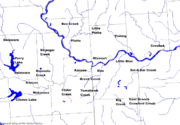
The Crooked River rises east of Lathrop
Lathrop, Missouri
Lathrop is a city in Clinton County, Missouri, United States. The population was 2,092 at the 2000 census.-Geography:Lathrop is located at .According to the United States Census Bureau, the city has a total area of , all of it land....
in southeastern Clinton County
Clinton County, Missouri
As of the census of 2000, there were 18,979 people, 7,152 households, and 5,299 families residing in the county. The population density was 45 people per square mile . There were 7,877 housing units at an average density of 19 per square mile...
and flows generally southeastwardly through Caldwell
Caldwell County, Missouri
Caldwell County is a county located in the U.S. state of Missouri. , the population was 8,969. Its county seat is Kingston. The county was organized in 1836 as a haven for the Mormons, who had been previously driven from Jackson County, Missouri in November of 1833 and had been refugees in...
and Ray counties. In southwestern Ray County it collects short east and west forks and flows into the Missouri River, about 4 miles (6 km) south of Hardin
Hardin, Missouri
Hardin is a city in Ray County, Missouri, United States. The population was 569 at the 2010 census.-Geography:Hardin is located at .According to the United States Census Bureau, the city has a total area of , all of it land....
.

