
Cripple Creek Historic District
Encyclopedia
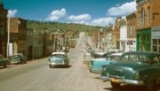
Cripple Creek Historic District is a historic district including Cripple Creek, Colorado
, USA and is significant for its gold mining era history.
It was declared a National Historic Landmark
in 1961.
Many Cripple Creek buildings post-date the gold mining era. The district includes a number of surviving structures, possibly including the following seven:
A photograph of each of the seven above is included in the NRHP Inventory documentation.
The boundary of the district is defined by high points around Cripple Creek to include the "natural setting reminiscent of the historic environment. Additionally, it encloses part of the extent of Poverty Gulch where some of the original ore discoveries were made as well as the County Hospital building which is located outside the town limits." (p.10) It runs from the peak of Mineral Hill (elevation 10,255 feet) southwest to a peak (elevation 9,855 feet), then to northeast corner of Mount Pisgah cemetery, then south along the east border of the cemetery to its southeast corner, then southeast to the peak that is 1600 feet to the northwest of Signal Hill (at elevation 9731), then northeast to the summit of Globe Hill (elevation 10,436), then northwest to peak of Carbonate Hill (elevation 10,335), finally east back to the peak of Mineral Hill.
Colorado State Highway 67
is the principal road through the area.
Cripple Creek, Colorado
The City of Cripple Creek is a Statutory City that is the county seat of Teller County, Colorado, United States. Cripple Creek is a former gold mining camp located southwest of Colorado Springs near the base of Pikes Peak. The Cripple Creek Historic District, which received National Historic...
, USA and is significant for its gold mining era history.
It was declared a National Historic Landmark
National Historic Landmark
A National Historic Landmark is a building, site, structure, object, or district, that is officially recognized by the United States government for its historical significance...
in 1961.
Many Cripple Creek buildings post-date the gold mining era. The district includes a number of surviving structures, possibly including the following seven:
- The Midland Terminal Depot
- Teller County Courthouse
- The Imperial Hotel
- The Old Homestead
- St. Paul's Catholic Church
- Mansard Roof House, on Warren Avenue
- The El Paso County Hospital, a brick Greek RevivalGreek Revival architectureThe Greek Revival was an architectural movement of the late 18th and early 19th centuries, predominantly in Northern Europe and the United States. A product of Hellenism, it may be looked upon as the last phase in the development of Neoclassical architecture...
style two story building.
A photograph of each of the seven above is included in the NRHP Inventory documentation.
The boundary of the district is defined by high points around Cripple Creek to include the "natural setting reminiscent of the historic environment. Additionally, it encloses part of the extent of Poverty Gulch where some of the original ore discoveries were made as well as the County Hospital building which is located outside the town limits." (p.10) It runs from the peak of Mineral Hill (elevation 10,255 feet) southwest to a peak (elevation 9,855 feet), then to northeast corner of Mount Pisgah cemetery, then south along the east border of the cemetery to its southeast corner, then southeast to the peak that is 1600 feet to the northwest of Signal Hill (at elevation 9731), then northeast to the summit of Globe Hill (elevation 10,436), then northwest to peak of Carbonate Hill (elevation 10,335), finally east back to the peak of Mineral Hill.
Colorado State Highway 67
Colorado State Highway 67
State Highway 67 is a long state highway encompassing five distinct segments in south-central Colorado. The route runs north from Wetmore to Sedalia, Colorado, traversing the former route of the Florence and Cripple Creek Railroad through Phantom Canyon as a county road and carrying part of the...
is the principal road through the area.