

Cresheim Creek
Encyclopedia
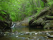
Stream
A stream is a body of water with a current, confined within a bed and stream banks. Depending on its locale or certain characteristics, a stream may be referred to as a branch, brook, beck, burn, creek, "crick", gill , kill, lick, rill, river, syke, bayou, rivulet, streamage, wash, run or...
in southeastern Pennsylvania
Pennsylvania
The Commonwealth of Pennsylvania is a U.S. state that is located in the Northeastern and Mid-Atlantic regions of the United States. The state borders Delaware and Maryland to the south, West Virginia to the southwest, Ohio to the west, New York and Ontario, Canada, to the north, and New Jersey to...
. Rising at Hill Crest in Cheltenham Township
Cheltenham Township, Pennsylvania
Cheltenham Township is a home rule municipality in Montgomery County, Pennsylvania, United States. Although it retains the word "Township" in its official name, it has been governed by a home rule charter since 1977 and is therefore not subject to the Pennsylvania Township Code. The population was...
(near the border between Montgomery County
Montgomery County, Pennsylvania
Montgomery County is a county located in the U.S. state of Pennsylvania, in the United States. As of 2010, the population was 799,874, making it the third most populous county in Pennsylvania . The county seat is Norristown.The county was created on September 10, 1784, out of land originally part...
and Northwest Philadelphia
Northwest Philadelphia
Northwest Philadelphia is a section of the city of Philadelphia, Pennsylvania. The official boundary is Stenton Avenue to the north, the Schuylkill river to the south, Spring Ln to the west, and Wister Street to the east. The area is divided by Wissahickon Creek into two subsections...
at Holy Sepulchre Cemetery
Holy Sepulchre Cemetery (Cheltenham Township, Pennsylvania)
Holy Sepulchre Cemetery is a Catholic cemetery in the U.S. state of Pennsylvania. It is a cemetery of the Archdiocese of Philadelphia. Located at 4001 West Cheltenham Avenue, it abuts the county line separating Cheltenham Township, Montgomery County from Northwest Philadelphia...
), it runs about 2.7 miles (4.3 km) southwest, passing through part of Northwest Philadelphia and dividing Mount Airy
Mount Airy, Philadelphia, Pennsylvania
Mount Airy is a neighborhood of Northwest Philadelphia in the state of Pennsylvania.-Boundaries:Mount Airy is bounded on the northwest by the Cresheim Valley, which is part of Fairmount Park. Beyond this lies Chestnut Hill. On the west side is the Wissahickon Gorge, which is also part of Fairmount...
from Chestnut Hill
Chestnut Hill, Philadelphia, Pennsylvania
Chestnut Hill is a neighborhood in the Northwest Philadelphia section of the United States city of Philadelphia, Pennsylvania.-Boundaries:Chestnut Hill is bounded as follows:...
, before emptying into the Wissahickon Creek
Wissahickon Creek
Wissahickon Creek is a stream in southeastern Pennsylvania. Rising in Montgomery County, Pennsylvania, it runs about 23 miles passing through and dividing Northwest Philadelphia before emptying into the Schuylkill River at Philadelphia...
at Devil's Pool not far south of the Valley Green Inn.
The Cresheim Valley is part of Fairmount Park
Fairmount Park
Fairmount Park is the municipal park system of Philadelphia, Pennsylvania. It consists of 63 parks, with , all overseen by the Philadelphia Department of Parks and Recreation, successor to the Fairmount Park Commission in 2010.-Fairmount Park proper:...
. The former railbed within it is also an easement for PECO
Exelon
Exelon Corporation is an electricity generating and distributing company headquartered in the Chase Tower in the Chicago Loop area of Chicago. It was created in October, 2000 by the merger of PECO Energy Company and Unicom, of Philadelphia and Chicago respectively. Unicom owned Commonwealth Edison...
powerlines
Electric power transmission
Electric-power transmission is the bulk transfer of electrical energy, from generating power plants to Electrical substations located near demand centers...
, which take advantage of the former railbed's grading and open space.
Cresheim Valley Drive runs beside the creek from Stenton Avenue until southwest of the tracks, where it bends away to become Emlen Street. The stone pergola
Pergola
A pergola, arbor or arbour is a garden feature forming a shaded walkway, passageway or sitting area of vertical posts or pillars that usually support cross-beams and a sturdy open lattice, often upon which woody vines are trained...
that stands at the southwest corner of the intersection of Germantown Avenue and Cresheim Valley Drive contains plaques honoring both the early German settlers of the Cresheim Valley and Samuel Newman Baxter, chief arborist of Fairmount Park from 1915 to 1945.
Pre-Euro-American and early-Euro-American periods
The area around Cresheim Creek was originally inhabited by the LenapeLenape
The Lenape are an Algonquian group of Native Americans of the Northeastern Woodlands. They are also called Delaware Indians. As a result of the American Revolutionary War and later Indian removals from the eastern United States, today the main groups live in Canada, where they are enrolled in the...
. 17th-century(1600s) settlers of the German Township
Germantown Township, Pennsylvania
Germantown Township, also known as German Township, is a defunct township that was located in Philadelphia County, Pennsylvania. The municipality ceased to exist and was incorporated into the City of Philadelphia following the passage of the Act of Consolidation, 1854.-History:Germantown Township,...
named the creek after the village from which they had emigrated (which is now part of Monsheim, Alzey-Worms, Rhineland-Palatinate
Monsheim
Monsheim is an Ortsgemeinde – a municipality belonging to a Verbandsgemeinde, a kind of collective municipality – in the Alzey-Worms district in Rhineland-Palatinate, Germany.- Location :...
). The aforementioned pergola plaque gives the settlers' spelling of the name as Krisheim. The settlers arrived in the 1680s. In 1700, they built Cresheim Cottage, the earliest permanent building in the vicinity, which is still standing at the intersection of Germantown Avenue and Gowen Avenue. (It's the smaller part of the present building; the larger part was built circa 1748.)
Cresheim Branch (Fort Washington Branch) of the Connecting Railway
From 1893 to 1953, a branch of the Connecting RailwayConnecting Railway
The Connecting Railway was a subsidiary of the Pennsylvania Railroad, incorporated to build a connection between the Philadelphia and Trenton Railroad and the PRR in the city of Philadelphia.-Connecting railway:...
, variously called the Cresheim Branch or Fort Washington Branch, diverged from the Chestnut Hill Branch (present-day Chestnut Hill West Line
Chestnut Hill West Line
The Chestnut Hill West Line , is a route of the SEPTA Regional Rail system. The route serves the northwestern section of Philadelphia with service to Germantown, Mount Airy, and Chestnut Hill...
) just north of Allen Lane station
Allen Lane (SEPTA station)
Allen Lane Station is a SEPTA Regional Rail station at 200 West Allens Lane in the Mount Airy neighborhood of Philadelphia, Pennsylvania, USA. The station stands at the intersection of Allens Lane and Cresheim Road. The station building was built circa 1880, according to the Philadelphia Architects...
(behind what is now the campus of New Covenant Church and several schools) and ran next to the creek's bank from there to the creek's headwaters at Hill Crest (near Holy Sepulchre Cemetery). (Incidentally, the headwaters of Tookany Creek
Frankford Creek
Frankford Creek is a minor tributary of the Delaware River in southeast Pennsylvania. The stream originates as Tookany Creek at Hill Crest in Cheltenham Township and meanders eastward, then southeastward, throughout Cheltenham Township, until a sharp bend near the Philadelphia border at Lawncrest,...
flow from this same hill eastward.) From Hill Crest, the railbed curved through Laverock to meet and follow the right-of-way that is now occupied by the Fort Washington Expressway portion of Route 309
Pennsylvania Route 309
Pennsylvania Route 309 is a major highway which runs for 134 miles through Pennsylvania in the United States. It connects Philadelphia and its northern suburbs to Allentown, Hazleton, and Wilkes-Barre. A limited-access highway portion of PA 309 in the Wilkes-Barre area is known as the North...
to Fort Hill, near Fort Washington, where it connected with the Trenton Cut-Off.
Outdoor enthusiasts of Northwest Philadelphia and various Montgomery County communities have encouraged their local legislators to effect the conversion of the Cresheim Branch's railbed into a rail trail
Rail trail
A rail trail is the conversion of a disused railway easement into a multi-use path, typically for walking, cycling and sometimes horse riding. The characteristics of former tracks—flat, long, frequently running through historical areas—are appealing for various development. The term sometimes also...
.,