

Connecticut Route 229
Encyclopedia
Route 229 is a state highway
in the western Greater Hartford
area of the U.S. state
of Connecticut
. It runs north–south from Interstate 84
in Southington to U.S. Route 6
in Bristol. Along the way, it intersects Route 72 in the Forestville section of Bristol.
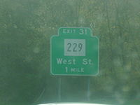 Route 229 nominally begins at the end of the eastbound Exit 31 off-ramp of I-84 in central Southington
, heading northward along West Street. State maintenance and the official southern end of Route 229 actually begins about 0.01 mile (0.0160934 km) south of the off-ramp. West Street is four lanes wide in the vicinity of the I-84 interchange, then becomes a two-lane urban arterial with operational turning lanes as it heads north. Just south of the Bristol
town line, Route 229 shifts to Middle Street and the road becomes four lanes wide.
Route 229 continues into Bristol, passing in front of the headquarters of ESPN
and the access road to the Lake Compounce
theme park. The four lane section ends at the bridge over the Pequabuck River. Route 229 meets and briefly overlaps with Route 72
(for 0.06 miles) in the Forestville section of the city just after crossing the river. North of Route 72, the road becomes known as King Street, which continues north for another 1.4 miles (2.3 km), passing in front of De Witt Page Park, until it reaches U.S. Route 6 (Farmington Avenue) in the Edgewood section of the city.
In the 1970s, several plans for spot improvements on Route 229 were announced by the Department of Transportatation. The original plan was to reconstruct Route 229 from I-84 to the Bristol
town line and widen it to four lanes. However, the plan had later changed to two lanes, with 8 feet (2.4 m) shoulders.
State highway
State highway, state road or state route can refer to one of three related concepts, two of them related to a state or provincial government in a country that is divided into states or provinces :#A...
in the western Greater Hartford
Greater Hartford
Greater Hartford is a region located in the state of Connecticut, centered on the state's capital of Hartford.Hartford's role as a focal point for the American insurance industry is known nationally. The vibrant music and arts scene defines the region's culture...
area of the U.S. state
U.S. state
A U.S. state is any one of the 50 federated states of the United States of America that share sovereignty with the federal government. Because of this shared sovereignty, an American is a citizen both of the federal entity and of his or her state of domicile. Four states use the official title of...
of Connecticut
Connecticut
Connecticut is a state in the New England region of the northeastern United States. It is bordered by Rhode Island to the east, Massachusetts to the north, and the state of New York to the west and the south .Connecticut is named for the Connecticut River, the major U.S. river that approximately...
. It runs north–south from Interstate 84
Interstate 84 in Connecticut
Interstate 84 is an East–West Interstate highway across the state of Connecticut into Danbury, Waterbury, Hartford and Union.-Route description:...
in Southington to U.S. Route 6
U.S. Route 6 in Connecticut
U.S. Route 6 is the portion of the cross-country U.S. Route 6 within the state of Connecticut. West of Hartford, the route either closely parallels or runs along Interstate 84. Interstate 84 has largely supplanted Route 6 as a through route in western Connecticut. East of Hartford, the route serves...
in Bristol. Along the way, it intersects Route 72 in the Forestville section of Bristol.
Route description
Southington, Connecticut
Southington is a town in Hartford County, Connecticut, United States. It is part of Connecticut's 1st congressional district. It is situated about 20 miles southwest of Hartford, about 80 miles northeast of New York City, 105 miles southwest of Boston and 77 miles west of Providence...
, heading northward along West Street. State maintenance and the official southern end of Route 229 actually begins about 0.01 mile (0.0160934 km) south of the off-ramp. West Street is four lanes wide in the vicinity of the I-84 interchange, then becomes a two-lane urban arterial with operational turning lanes as it heads north. Just south of the Bristol
Bristol, Connecticut
Bristol is a suburban city located in Hartford County, Connecticut, United States southwest of Hartford. According to 2006 Census Bureau estimates, the population of the city is 61,353. Bristol is primarily known as the home of ESPN, whose central studios are in the city. Bristol is also home to...
town line, Route 229 shifts to Middle Street and the road becomes four lanes wide.
Route 229 continues into Bristol, passing in front of the headquarters of ESPN
ESPN
Entertainment and Sports Programming Network, commonly known as ESPN, is an American global cable television network focusing on sports-related programming including live and pre-taped event telecasts, sports talk shows, and other original programming....
and the access road to the Lake Compounce
Lake Compounce
Lake Compounce is an amusement park located in Bristol, Connecticut, United States and a part of the neighboring town of Southington, Connecticut; the lake itself lies completely in Southington. It is the oldest continuously operating amusement park in North America, having operated every year...
theme park. The four lane section ends at the bridge over the Pequabuck River. Route 229 meets and briefly overlaps with Route 72
Route 72 (Connecticut)
Route 72 is a state highway in the western part of the Greater Hartford area. Route 72 is an L-shaped route with a north–south section in Plymouth and Harwinton and an east–west section from Bristol to New Britain...
(for 0.06 miles) in the Forestville section of the city just after crossing the river. North of Route 72, the road becomes known as King Street, which continues north for another 1.4 miles (2.3 km), passing in front of De Witt Page Park, until it reaches U.S. Route 6 (Farmington Avenue) in the Edgewood section of the city.
History
Route 229 was originally just a series of town roads before the late 1950s. In anticipation of increased traffic as a result of the construction of I-84, Southington lobbied for state maintenance of a section of West Street. This was accepted into the state highway system on October 14, 1959. Several years later, Bristol also applied to have Middle Street and King Street turned over to the state in anticipation of through traffic between I-84 and downtown Bristol. The Highway Department accepted those streets into the state highway system on August 20, 1962. Route 229 was formally designated in 1963 as a result of the Route Reclassification Act.In the 1970s, several plans for spot improvements on Route 229 were announced by the Department of Transportatation. The original plan was to reconstruct Route 229 from I-84 to the Bristol
Bristol
Bristol is a city, unitary authority area and ceremonial county in South West England, with an estimated population of 433,100 for the unitary authority in 2009, and a surrounding Larger Urban Zone with an estimated 1,070,000 residents in 2007...
town line and widen it to four lanes. However, the plan had later changed to two lanes, with 8 feet (2.4 m) shoulders.
Junction list
| Location | Mile | Roads intersected | Notes |
|---|