
Connecticut Route 117
Encyclopedia
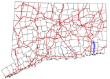
Route 117 is a state highway
in southeastern Connecticut
, running from Groton
to Preston
.
in the village of Poquonnock Bridge in Groton
. It starts out as Newtown Road then changes to North Road. About a mile north of US 1, Route 117 has an interchange with I-95 (Exit 88), then continues northward towards the village of Center Groton, where it meets Route 184. There is also access to the Star Plaza shopping area near this junction. Route 117 then enters the town of Ledyard
as Center Groton Road. It intersects with Route 214 in Ledyard Center then continues north for another 3.2 miles (5.1 km) until the town line with Preston
. In Preston, the road becomes known as Hallville-Poquetanuck Road. Just north of the town line it meets Route 2A
which joins Route 117 as they head north towards Route 2
in the village of Hallville. Immediately after crossing Indiantown Brook, Routes 117 and 2A end at Route 2.
Highway from its intersection with Route 184
in Groton to the Ledyard-Preston town line.
. Route 117 was established in 1963 as part of the 1962 Route Reclassification Act as a redesignation of old SR 588. One year later, the Route 117 designation was extended south to US 1 using a newly-constructed extension of North Road. A portion of the current route in Ledyard used to be an old alignment of Route 27
.
State highway
State highway, state road or state route can refer to one of three related concepts, two of them related to a state or provincial government in a country that is divided into states or provinces :#A...
in southeastern Connecticut
Connecticut
Connecticut is a state in the New England region of the northeastern United States. It is bordered by Rhode Island to the east, Massachusetts to the north, and the state of New York to the west and the south .Connecticut is named for the Connecticut River, the major U.S. river that approximately...
, running from Groton
Groton, Connecticut
Groton is a town located on the Thames River in New London County, Connecticut, United States. The population was 39,907 at the 2000 census....
to Preston
Preston, Connecticut
Preston is a town in New London County, Connecticut, United States. The population was 4,688 at the 2000 census. The town includes the villages of Long Society, Preston City, and Poquetanuck.-History:...
.
Route description
Route 117 begins at an intersection with US 1U.S. Route 1 in Connecticut
In the U.S. state of Connecticut, U.S. Route 1 is a major east–west state highway along Long Island Sound. It has been replaced by Interstate 95 as a through route, which it closely parallels, and now primarily serves as a local business route...
in the village of Poquonnock Bridge in Groton
Groton, Connecticut
Groton is a town located on the Thames River in New London County, Connecticut, United States. The population was 39,907 at the 2000 census....
. It starts out as Newtown Road then changes to North Road. About a mile north of US 1, Route 117 has an interchange with I-95 (Exit 88), then continues northward towards the village of Center Groton, where it meets Route 184. There is also access to the Star Plaza shopping area near this junction. Route 117 then enters the town of Ledyard
Ledyard, Connecticut
As of the census of 2000, there were 14,687 people, 5,286 households, and 4,101 families residing in the town. The population density was 385.1 people per square mile . There were 5,486 housing units at an average density of 143.8 per square mile...
as Center Groton Road. It intersects with Route 214 in Ledyard Center then continues north for another 3.2 miles (5.1 km) until the town line with Preston
Preston, Connecticut
Preston is a town in New London County, Connecticut, United States. The population was 4,688 at the 2000 census. The town includes the villages of Long Society, Preston City, and Poquetanuck.-History:...
. In Preston, the road becomes known as Hallville-Poquetanuck Road. Just north of the town line it meets Route 2A
Route 2A (Connecticut)
Route 2A is a state highway in the U.S. state of Connecticut. It is a mostly expressway alternate route of Route 2 that bypasses the downtown area of the city of Norwich and serves as the main access road to the Mohegan Sun casino....
which joins Route 117 as they head north towards Route 2
Route 2 (Connecticut)
Route 2 is a state highway in Connecticut and is in length. It is a primary state route, with a freeway section connecting Hartford to Norwich and a non-freeway section extending to Stonington.-Route description:...
in the village of Hallville. Immediately after crossing Indiantown Brook, Routes 117 and 2A end at Route 2.
Special Designation
Route 117 is designated the Colonel LedyardWilliam Ledyard
William Ledyard was a lieutenant colonel in the Connecticut militia who was killed in the American Revolutionary War....
Highway from its intersection with Route 184
Connecticut Route 184
Route 184 is a state highway in southeastern Connecticut, running from Groton to North Stonington.-Route description:Route 184 begins as a freeway from northbound Exit 86 of I-95 just north of the city of Groton. It crosses over Route 12 later at an interchange and soon becomes a surface street...
in Groton to the Ledyard-Preston town line.
History
Since the 1930s, the road between Center Groton and Ledyard center was an unsigned state road known as SR 588. In 1959, SR 588 was extended north using the Colonel Ledyard Highway to the village of PoquetanuckPoquetanuck
Poquetanuck is a village in the town of Preston, Connecticut, located near the banks of a bay known as Poquetanuck Cove that opens to the Thames River...
. Route 117 was established in 1963 as part of the 1962 Route Reclassification Act as a redesignation of old SR 588. One year later, the Route 117 designation was extended south to US 1 using a newly-constructed extension of North Road. A portion of the current route in Ledyard used to be an old alignment of Route 27
Route 27 (Connecticut)
Route 27 is a north–south state highway in southeastern Connecticut running for from U.S. Route 1 in Mystic to Route 184 in Old Mystic .- Route description:...
.