
Confluence, Pennsylvania
Encyclopedia
Confluence is a borough in Somerset County
, Pennsylvania
, United States
. It is part of the Johnstown, Pennsylvania
Metropolitan Statistical Area. The population was 834 at the 2000 census.
Confluence is so named for the juncture of the Casselman River
and Laurel Hill Creek
with the Youghiogheny River
. It therefore provides many opportunities for boating and fishing (and hiking, as Pennsylvania's highest point, Mount Davis
, is located nearby).
According to the United States Census Bureau
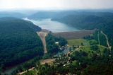
, the borough has a total area of 1.6 square miles (4.1 km²), of which, 1.6 square miles (4.1 km²) of it is land and 0.1 square mile (0.258998811 km²) of it (3.03%) is water. The borough is bordered to the south by the 2840 acres (11.5 km²) Youghiogheny River Lake
and to the north by the 19052 acres (77.1 km²) Ohiopyle State Park
.
of 2000, there were 834 people, 349 households, and 211 families residing in the borough. The population density
was 522.4 people per square mile (201.3/km²). There were 404 housing units at an average density of 253.0 per square mile (97.5/km²). The racial makeup of the borough was 99.52% White, 0.24% African American, and 0.24% from two or more races. Hispanic or Latino of any race were 0.24% of the population.
There were 349 households out of which 25.8% had children under the age of 18 living with them, 48.4% were married couples
living together, 9.2% had a female householder with no husband present, and 39.3% were non-families. 34.4% of all households were made up of individuals and 21.8% had someone living alone who was 65 years of age or older. The average household size was 2.26 and the average family size was 2.91.
In the borough the population was spread out with 20.3% under the age of 18, 7.0% from 18 to 24, 26.9% from 25 to 44, 22.7% from 45 to 64, and 23.3% who were 65 years of age or older. The median age was 42 years. For every 100 females there were 84.9 males. For every 100 females age 18 and over, there were 79.7 males.
The median income for a household in the borough was $23,462, and the median income for a family was $31,181. Males had a median income of $26,705 versus $19,750 for females. The per capita income
for the borough was $12,129. About 15.0% of families and 21.2% of the population were below the poverty line, including 28.7% of those under age 18 and 20.4% of those age 65 or over.
Somerset County, Pennsylvania
Somerset County is a county located in the state of Pennsylvania. As of 2010, the population was 77,742. Somerset County was created on April 17, 1795, from part of Bedford County and named for Somerset, United Kingdom. Its county seat is Somerset. It is part of the Johnstown, Pennsylvania,...
, Pennsylvania
Pennsylvania
The Commonwealth of Pennsylvania is a U.S. state that is located in the Northeastern and Mid-Atlantic regions of the United States. The state borders Delaware and Maryland to the south, West Virginia to the southwest, Ohio to the west, New York and Ontario, Canada, to the north, and New Jersey to...
, United States
United States
The United States of America is a federal constitutional republic comprising fifty states and a federal district...
. It is part of the Johnstown, Pennsylvania
Johnstown, Pennsylvania
Johnstown is a city in Cambria County, Pennsylvania, United States, west-southwest of Altoona, Pennsylvania and east of Pittsburgh. The population was 20,978 at the 2010 census. It is the principal city of the Johnstown, Pennsylvania, Metropolitan Statistical Area, which includes Cambria County...
Metropolitan Statistical Area. The population was 834 at the 2000 census.
Geography
Confluence is located at 39°48′36"N 79°21′24"W (39.809997, -79.356692).Confluence is so named for the juncture of the Casselman River
Casselman River
The Casselman River is a tributary of the Youghiogheny River in western Maryland and Pennsylvania in the United States.The Casselman River rises atop the plateau of western Maryland and then follows a great arc across the Laurel Highlands of Somerset County, Pennsylvania to the appropriately named...
and Laurel Hill Creek
Laurel Hill Creek
Laurel Hill Creek is a tributary of the Casselman River in Somerset County, Pennsylvania, in the United States. It is part of the Youghiogheny River watershed, flowing to the Monongahela River, the Ohio River, and ultimately the Mississippi River....
with the Youghiogheny River
Youghiogheny River
The Youghiogheny River , or the Yough for short, is a tributary of the Monongahela River in the U.S. states of West Virginia, Maryland, and Pennsylvania...
. It therefore provides many opportunities for boating and fishing (and hiking, as Pennsylvania's highest point, Mount Davis
Mount Davis (Pennsylvania)
Mount Davis is the highest point in Pennsylvania. Located in the 5,685 acre Forbes State Forest in Elk Lick Township, Somerset County, it rises to 3,213 ft...
, is located nearby).
According to the United States Census Bureau
United States Census Bureau
The United States Census Bureau is the government agency that is responsible for the United States Census. It also gathers other national demographic and economic data...
, the borough has a total area of 1.6 square miles (4.1 km²), of which, 1.6 square miles (4.1 km²) of it is land and 0.1 square mile (0.258998811 km²) of it (3.03%) is water. The borough is bordered to the south by the 2840 acres (11.5 km²) Youghiogheny River Lake
Youghiogheny River Lake
The Youghiogheny River Lake is a flood control reservoir in southwestern Pennsylvania and western Maryland. It was formed in 1944 by the damming of the Youghiogheny River upstream from Confluence, Pennsylvania....
and to the north by the 19052 acres (77.1 km²) Ohiopyle State Park
Ohiopyle State Park
Ohiopyle State Park is a Pennsylvania state park on in Dunbar, Henry Clay and Stewart Townships, Fayette County, Pennsylvania in the United States. The focal point of the park is the more than of the Youghiogheny River Gorge that passes through the park. The river provides some of the best...
.
Demographics
As of the censusCensus
A census is the procedure of systematically acquiring and recording information about the members of a given population. It is a regularly occurring and official count of a particular population. The term is used mostly in connection with national population and housing censuses; other common...
of 2000, there were 834 people, 349 households, and 211 families residing in the borough. The population density
Population density
Population density is a measurement of population per unit area or unit volume. It is frequently applied to living organisms, and particularly to humans...
was 522.4 people per square mile (201.3/km²). There were 404 housing units at an average density of 253.0 per square mile (97.5/km²). The racial makeup of the borough was 99.52% White, 0.24% African American, and 0.24% from two or more races. Hispanic or Latino of any race were 0.24% of the population.
There were 349 households out of which 25.8% had children under the age of 18 living with them, 48.4% were married couples
Marriage
Marriage is a social union or legal contract between people that creates kinship. It is an institution in which interpersonal relationships, usually intimate and sexual, are acknowledged in a variety of ways, depending on the culture or subculture in which it is found...
living together, 9.2% had a female householder with no husband present, and 39.3% were non-families. 34.4% of all households were made up of individuals and 21.8% had someone living alone who was 65 years of age or older. The average household size was 2.26 and the average family size was 2.91.
In the borough the population was spread out with 20.3% under the age of 18, 7.0% from 18 to 24, 26.9% from 25 to 44, 22.7% from 45 to 64, and 23.3% who were 65 years of age or older. The median age was 42 years. For every 100 females there were 84.9 males. For every 100 females age 18 and over, there were 79.7 males.
The median income for a household in the borough was $23,462, and the median income for a family was $31,181. Males had a median income of $26,705 versus $19,750 for females. The per capita income
Per capita income
Per capita income or income per person is a measure of mean income within an economic aggregate, such as a country or city. It is calculated by taking a measure of all sources of income in the aggregate and dividing it by the total population...
for the borough was $12,129. About 15.0% of families and 21.2% of the population were below the poverty line, including 28.7% of those under age 18 and 20.4% of those age 65 or over.