
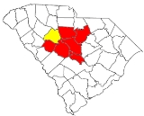
Columbia, South Carolina metropolitan area
Encyclopedia
South Carolina
South Carolina is a state in the Deep South of the United States that borders Georgia to the south, North Carolina to the north, and the Atlantic Ocean to the east. Originally part of the Province of Carolina, the Province of South Carolina was one of the 13 colonies that declared independence...
, anchored by the city of Columbia
Columbia, South Carolina
Columbia is the state capital and largest city in the U.S. state of South Carolina. The population was 129,272 according to the 2010 census. Columbia is the county seat of Richland County, but a portion of the city extends into neighboring Lexington County. The city is the center of a metropolitan...
. As of the 2000 census
United States Census, 2000
The Twenty-second United States Census, known as Census 2000 and conducted by the Census Bureau, determined the resident population of the United States on April 1, 2000, to be 281,421,906, an increase of 13.2% over the 248,709,873 persons enumerated during the 1990 Census...
, the MSA had a population of 647,158 (though a July 1, 2009 estimate placed the population at 744,730). It is the largest metropolitan statistical area in the state of South Carolina.
Counties
- CalhounCalhoun County, South CarolinaCalhoun County is a county located in the U.S. state of South Carolina. In 2000, its population was 15,185; a 2005 Census Bureau estimate placed the population at 15,100. It is named for John C. Calhoun, the former U.S. Vice-President, Senator, Representative and cabinet member from South...
- Fairfield
- Kershaw
- Lexington
- RichlandRichland County, South CarolinaRichland County is a county located in the U.S. state of South Carolina. The 2000 U.S. census recorded its population to be 320,677. In 2010, the U.S. Census Bureau recorded that its population had reached 384,504. It is the second most populous county in South Carolina, behind only Greenville...
- Saluda
Places with more than 100,000 inhabitants
- ColumbiaColumbia, South CarolinaColumbia is the state capital and largest city in the U.S. state of South Carolina. The population was 129,272 according to the 2010 census. Columbia is the county seat of Richland County, but a portion of the city extends into neighboring Lexington County. The city is the center of a metropolitan...
(Principal city)
Places with 10,000 to 25,000 inhabitants
- CayceCayce, South CarolinaCayce is a city in Lexington and Richland counties in the U.S. state of South Carolina, along the Congaree River. The population was 12,150 at the 2000 census...
- DentsvilleDentsville, South CarolinaDentsville is a census-designated place in Richland County, South Carolina, United States. The population was 13,009 at the 2000 census. It is part of the Columbia, South Carolina Metropolitan Statistical Area.-Geography:...
(census-designated place) - Forest AcresForest Acres, South CarolinaForest Acres is an upscale city in Richland County, South Carolina, United States. The population was 10,558 at the 2000 census. It is part of the Columbia, South Carolina Metropolitan Statistical Area.-Geography:...
- IrmoIrmo, South CarolinaIrmo is a town in Lexington and Richland counties in the U.S. state of South Carolina and a suburb of Columbia. It is 12 miles outside of the city center of Columbia and is part of the Columbia Metropolitan Statistical Area...
- LexingtonLexington, South CarolinaLexington is a town in and the county seat of Lexington County, South Carolina, United States. The population was 17,870 at the 2010 census.-Geography:Lexington is located at ....
- Seven OaksSeven Oaks, South CarolinaSeven Oaks is a census-designated place in Lexington County, South Carolina, United States, 6 miles outside of Columbia. The population was 15,755 at the 2000 census...
(census-designated place) - St. AndrewsSt. Andrews, South CarolinaSt. Andrews is a census-designated place in Richland County, South Carolina, United States. The population was 21,814 at the 2000 census. It is part of the Columbia, South Carolina Metropolitan Statistical Area.-Geography:St...
(census-designated place) - West ColumbiaWest Columbia, South CarolinaWest Columbia is a city in Lexington County, South Carolina, United States. The population was 13,064 at the 2000 census. It is part of the Columbia, South Carolina Metropolitan Statistical Area....
Places with 5,000 to 10,000 inhabitants
- Batesburg-LeesvilleBatesburg-Leesville, South CarolinaBatesburg-Leesville is a town in Lexington and Saluda counties in the U.S. state of South Carolina. The population was 5,517 at the 2000 census...
- CamdenCamden, South CarolinaCamden is the fourth oldest city in the U.S. state of South Carolina and is also the county seat of Kershaw County, South Carolina, United States. The population was an estimated 7,103 in 2009...
- LugoffLugoff, South CarolinaLugoff is a small census-designated place in Kershaw County, South Carolina, United States. The population was 6,278 at the 2000 census. The population was nearly 85% rural in 2000...
(census-designated place) - Oak GroveOak Grove, South CarolinaOak Grove is a census-designated place in Lexington County, South Carolina, United States. The population was 8,183 at the 2000 census. It is part of the Columbia, South Carolina Metropolitan Statistical Area.-Geography:...
(census-designated place) - Red BankRed Bank, South CarolinaRed Bank is a census-designated place in Lexington County, South Carolina, United States. The population was 8,811 at the 2000 census. It is part of the Columbia, South Carolina Metropolitan Statistical Area-Geography:...
(census-designated place) - WoodfieldWoodfield, South CarolinaWoodfield is a census-designated place in Richland County, South Carolina, United States. The population was 9,238 at the 2000 census. It is part of the Columbia, South Carolina Metropolitan Statistical Area.-Geography:Woodfield is located at ....
(census-designated place)
Places with 1,000 to 5,000 inhabitants
- GastonGaston, South CarolinaGaston is a town in Lexington County, South Carolina, United States. The population was 1,645 at the 2010 census. It is part of the Columbia, South Carolina Metropolitan Statistical Area.-Geography:Gaston is located at ....
- Lake Murray of RichlandLake Murray of Richland, South CarolinaLake Murray of Richland is a census-designated place in Richland County, South Carolina, United States. The population was 3,526 at the 2000 census...
(census-designated place) - Pine RidgePine Ridge, South CarolinaPine Ridge is a town in Lexington County, South Carolina, United States. The population was 1,593 at the 2000 census. It is part of the Columbia, South Carolina Metropolitan Statistical Area.-Geography:Pine Ridge is located at ....
- St. MatthewsSt. Matthews, South CarolinaSt. Matthews is a town in Calhoun County, South Carolina, United States. The population was 2,107 at the 2000 census. It is the county seat of Calhoun County.St. Matthews is part of the Columbia, South Carolina Metropolitan Statistical Area.-Geography:St...
- SaludaSaluda, South CarolinaSaluda is a town in Saluda County, South Carolina, along the Little Saluda River. The population was 3,066 at the 2000 census. It is the county seat of Saluda County.Saluda is part of the Columbia, South Carolina Metropolitan Statistical Area.-Geography:...
- South CongareeSouth Congaree, South CarolinaSouth Congaree is a town in Lexington County, South Carolina, United States. The population was 2,266 at the 2000 census. It is part of the Columbia, South Carolina Metropolitan Statistical Area.-Geography:...
- SpringdaleSpringdale, Lexington County, South CarolinaSpringdale is a town in Lexington County, South Carolina, in the United States. The population was 2,877 at the 2000 census. It is part of the Columbia, South Carolina Metropolitan Statistical Area.1226835-Geography:...
- Winnsboro MillsWinnsboro Mills, South CarolinaWinnsboro Mills is a census-designated place in Fairfield County, South Carolina, United States. The population was 2,263 at the 2000 census...
(census-designated place) - WinnsboroWinnsboro, South CarolinaWinnsboro is a town in Fairfield County, South Carolina, United States. The population was 3,599 at the 2000 census. It is the county seat of Fairfield County. Winnsboro is part of the Columbia, South Carolina Metropolitan Statistical Area....
Places with less than 1,000 inhabitants
- Arcadia LakesArcadia Lakes, South CarolinaArcadia Lakes is a town in Richland County, South Carolina, United States. The population was 882 at the 2000 census. It is part of the Columbia, South Carolina Metropolitan Statistical Area.-Geography:Arcadia Lakes is located at ....
- BethuneBethune, South CarolinaBethune is a town in Kershaw County, South Carolina, United States. The population was 352 at the 2000 census. It is part of the Columbia, South Carolina Metropolitan Statistical Area.-Geography:Bethune is located at ....
- BlythewoodBlythewood, South CarolinaBlythewood is a town in Fairfield and Richland counties in the U.S. state of South Carolina. The population was 2,034 at the 2010 census. It is part of the Columbia, South Carolina Metropolitan Statistical Area....
- CameronCameron, South CarolinaCameron is a town in Calhoun County, South Carolina, United States. The population was 449 at the 2000 census. It is part of the Columbia, South Carolina Metropolitan Statistical Area.-Geography:Cameron is located at ....
- ChapinChapin, South CarolinaChapin, also known as the capital of Lake Murray, is a town located in Lexington County, South Carolina. Chapin was founded by Martin Chapin in 1889. The following year, 1890, the railroad was built to connect Chapin to Columbia, South Carolina and other major regions. The population of Chapin was...
- EastoverEastover, South CarolinaEastover is a town in Richland County, South Carolina, United States. The population was 830 at the 2000 census. It is part of the Columbia, South Carolina Metropolitan Statistical Area.-Geography:Eastover is located at ....
- ElginElgin, Kershaw County, South CarolinaElgin is a town in Kershaw County, South Carolina, United States. The population was 806 at the 2000 census. The population was nearly 94% rural in 2010. It is part of the Columbia, South Carolina Metropolitan Statistical Area.-Geography:...
- GilbertGilbert, South CarolinaGilbert is a town in Lexington County, South Carolina, United States. The population was 500 at the 2000 census. It is part of the Columbia, South Carolina Metropolitan Statistical Area.-Town Overview:Gilbert is located at ....
- MonettaMonetta, South CarolinaMonetta is a town in Aiken and Saluda counties in the U.S. state of South Carolina. The population was 220 at the 2000 census.The Saluda County portion of Monetta is part of the Columbia, South Carolina Metropolitan Statistical Area, while the Aiken County portion is part of the Augusta, Georgia...
(partial) - PelionPelion, South CarolinaPelion is a town in Lexington County, South Carolina, United States. The population was 553 at the 2000 census. It is part of the Columbia, South Carolina Metropolitan Statistical Area...
- Ridge SpringRidge Spring, South CarolinaRidge Spring is a town in Saluda County, South Carolina, United States. The population was 823 at the 2000 census. It is part of the Columbia, South Carolina Metropolitan Statistical Area.-Geography:Ridge Spring is located at ....
- RidgewayRidgeway, South CarolinaRidgeway is a town in Fairfield County, South Carolina, United States. The population was 328 at the 2000 census. It is part of the Columbia, South Carolina Metropolitan Statistical Area.-Geography:Ridgeway is located at ....
- SummitSummit, South CarolinaSummit is a town in Lexington County, South Carolina, United States. The population was 219 at the 2000 census. It is part of the Columbia, South Carolina Metropolitan Statistical Area.-Geography:Summit is located at ....
- SwanseaSwansea, South CarolinaSwansea is a town in Lexington County, South Carolina, United States. The population was 827 at the 2010 census. It is part of the Columbia, South Carolina Metropolitan Statistical Area.-Geography:Swansea is located at...
- WardWard, South CarolinaWard is a town in Saluda County, South Carolina, United States. The population was 110 at the 2000 census. It is part of the Columbia, South Carolina Metropolitan Statistical Area.-Geography:Ward is located at ....
Unincorporated places
- AntiochAntioch, South CarolinaAntioch is a small unincorporated community in Kershaw County, South Carolina, United States, east of Camden. The community is part of the Columbia, South Carolina Metropolitan Statistical Area....
- Arthurtown
- BallentineBallentine, South CarolinaBallentine is an unincorporated community in Richland County, South Carolina, United States. It is part of the Columbia, South Carolina Metropolitan Statistical Area....
- Boyden Arbor
- Boykin
- Cassatt
- Creston
- Feasterville
- Fort Motte
- GadsdenGadsden, South CarolinaGadsden is an unincorporated community in Richland County, South Carolina serving SC 48 and SC 769. The population of the town is 799 and it is part of the Columbia, South Carolina metropolitan area.-External links:...
- Harbison
- Hilton
- HopkinsHopkins, South CarolinaHopkins is an unincorporated community in Richland County, South Carolina, United States that was founded in circa 1836 named after John Hopkins...
- Horrell HillHorrell Hill, South CarolinaHorrel Hill is an unincorporated community in Lower Richland County, South Carolina, South Carolina. Situated south of Fort Jackson and northwest of McEntire Joint National Guard Base, it is centered at about the intersection of Garner's Ferry Road and Harmon Road/Horrel Hill Road...
- Killian
- Kingville
- Leesburg
- Liberty Hill
- Lone StarLone Star, South CarolinaLone Star is an unincorporated community in Calhoun County, South Carolina, United States. The community has the ZIP Code of 29030 and lies at approximately 33.63 latitude and -80.59 longitude, with an elevation of 171 feet. It is part of the Columbia, South Carolina Metropolitan Statistical...
- Lykes
- MitfordMitford, South CarolinaMitford is an unincorporated community in Fairfield County, South Carolina, United States. Its altitude is 568 feet .-References:...
- Olympia
- Pontiac
- Sandy RunSandy Run, South CarolinaSandy Run is an unincorporated community in Calhoun County, South Carolina, United States. Its elevation is 154 feet .-References:...
- Spring Hill
- State Park
- Wateree
- WestvilleWestville, South CarolinaWestville is an unincorporated community in Kershaw County, South Carolina, United States. It is part of the Columbia, South Carolina Metropolitan Statistical Area....
- White RockWhite Rock, South CarolinaWhite Rock is an unincorporated community in northwestern Richland County, South Carolina, United States, a few miles north of Lake Murray. Although it is unincorporated, it has a post office, with the ZIP Code of 29177. The population of the ZCTA for ZIP Code 29177 was 463 at the 2000...
- Windsor Estates
Demographics
As of the censusCensus
A census is the procedure of systematically acquiring and recording information about the members of a given population. It is a regularly occurring and official count of a particular population. The term is used mostly in connection with national population and housing censuses; other common...
of 2000, there were 647,158 people, 245,347 households, and 167,105 families residing within the MSA. The racial makeup of the MSA was 63.40% White, 32.90% African American, 0.27% Native American, 1.24% Asian, 0.06% Pacific Islander, 1.01% from other races
Race (United States Census)
Race and ethnicity in the United States Census, as defined by the Federal Office of Management and Budget and the United States Census Bureau, are self-identification data items in which residents choose the race or races with which they most closely identify, and indicate whether or not they are...
, and 1.12% from two or more races. Hispanic or Latino of any race were 2.41% of the population.
The median income for a household in the MSA was $37,051, and the median income for a family was $44,051. Males had a median income of $32,119 versus $23,312 for females. The per capita income
Per capita income
Per capita income or income per person is a measure of mean income within an economic aggregate, such as a country or city. It is calculated by taking a measure of all sources of income in the aggregate and dividing it by the total population...
for the MSA was $18,150.
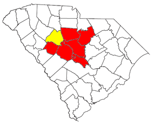
Combined Statistical Area
The Columbia–NewberryNewberry, South Carolina
Newberry is a city in Newberry County, South Carolina, 43 miles west -northwest of Columbia. The charter was adopted in 1894. In 1890, 3,020 people lived in Newberry, South Carolina; in 1900, 4,607; in 1910, 5,028; and in 1940, 7,510. The population was 10,580 at the 2000 census. It is the county...
Combined Statistical Area is made up of seven counties in central South Carolina. The statistical area includes one metropolitan area
United States metropolitan area
In the United States a metropolitan statistical area is a geographical region with a relatively high population density at its core and close economic ties throughout the area. Such regions are not legally incorporated as a city or town would be, nor are they legal administrative divisions like...
and one micropolitan area
United States micropolitan area
United States Micropolitan Statistical Areas , as defined by the United States Office of Management and Budget, are urban areas in the United States based around a core city or town with a population of 10,000 to 49,999. The micropolitan area designation was created in 2003...
. As of the 2000 Census, the CSA had a population of 683,266 (though a July 1, 2009 estimate placed the population at 783,493), and is the second largest CSA in South Carolina.
- Metropolitan Statistical Areas (MSAs)
- Columbia (Calhoun, Fairfield, Kershaw, Lexington, Saluda, and Richland counties)
- Micropolitan Statistical Areas (μSAs)
- Newberry (Newberry County)