
Cockayne, North Yorkshire
Encyclopedia
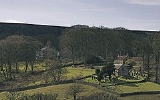
Cockayne is a hamlet and ridge in North Yorkshire
, England
.
It is the largest settlement in the civil parish
of Bransdale, in the North York Moors
national park, near the village of Chop Gate (3 miles, 5 km as the crow flies, though much further by road.)
The nearest towns are Helmsley
(9 miles, 14 km) and Kirkbymoorside
(10 miles, 16 km.)
The Cleveland Way
long distance footpath crosses the northern end of the ridge, reaching a summit of 441 m at Cockayne Head.
The settlement, under the southern tip of the ridge, is a mere 225 m above sea level, according to the Ordnance Survey
.
Cockayne is at the head of Bransdale, a southward facing valley cut into the moors.
The hamlet is, with the exception of the Church and Glebe, entirely owned by the National Trust. The overwhelming part of the 1925 acre Bransdale estate was transferred to the National Trust
through National Land Fund
procedures in 1972 and comprises all the farmland and a small amount of woodland in the valley.


North Yorkshire
North Yorkshire is a non-metropolitan or shire county located in the Yorkshire and the Humber region of England, and a ceremonial county primarily in that region but partly in North East England. Created in 1974 by the Local Government Act 1972 it covers an area of , making it the largest...
, England
England
England is a country that is part of the United Kingdom. It shares land borders with Scotland to the north and Wales to the west; the Irish Sea is to the north west, the Celtic Sea to the south west, with the North Sea to the east and the English Channel to the south separating it from continental...
.
It is the largest settlement in the civil parish
Civil parish
In England, a civil parish is a territorial designation and, where they are found, the lowest tier of local government below districts and counties...
of Bransdale, in the North York Moors
North York Moors
The North York Moors is a national park in North Yorkshire, England. The moors are one of the largest expanses of heather moorland in the United Kingdom. It covers an area of , and it has a population of about 25,000...
national park, near the village of Chop Gate (3 miles, 5 km as the crow flies, though much further by road.)
The nearest towns are Helmsley
Helmsley
Helmsley is a market town and civil parish in the Ryedale district of North Yorkshire, England. The town is located at the point where the valleys of Bilsdale and Ryedale leave the higher moorland and join the flat Vale of Pickering. It is situated on the River Rye and lies on the A170 road, east...
(9 miles, 14 km) and Kirkbymoorside
Kirkbymoorside
Kirkbymoorside is a small market town and civil parish in the Ryedale district of North Yorkshire, England which lies approximately 25 miles north of York midway between Pickering and Helmsley, and has a population of approximately 3,000.-History:...
(10 miles, 16 km.)
The Cleveland Way
Cleveland Way
The Cleveland Way is a National Trail in ancient Cleveland in Northern England. It runs 110 miles from Helmsley to Filey, skirting the North York Moors National Park.-History:The trail was opened in 1969...
long distance footpath crosses the northern end of the ridge, reaching a summit of 441 m at Cockayne Head.
The settlement, under the southern tip of the ridge, is a mere 225 m above sea level, according to the Ordnance Survey
Ordnance Survey
Ordnance Survey , an executive agency and non-ministerial government department of the Government of the United Kingdom, is the national mapping agency for Great Britain, producing maps of Great Britain , and one of the world's largest producers of maps.The name reflects its creation together with...
.
Cockayne is at the head of Bransdale, a southward facing valley cut into the moors.
The hamlet is, with the exception of the Church and Glebe, entirely owned by the National Trust. The overwhelming part of the 1925 acre Bransdale estate was transferred to the National Trust
National Trust for Places of Historic Interest or Natural Beauty
The National Trust for Places of Historic Interest or Natural Beauty, usually known as the National Trust, is a conservation organisation in England, Wales and Northern Ireland...
through National Land Fund
National Land Fund
The National Land Fund of the United Kingdom was created in 1946 to secure culturally significant property for the nation as a memorial to the dead of World War II. Proposed by Chancellor of the Exchequer, Hugh Dalton, the Fund was confirmed in section 48 of the Finance Act 1946 with a sum of...
procedures in 1972 and comprises all the farmland and a small amount of woodland in the valley.