Clearing, Chicago
Encyclopedia
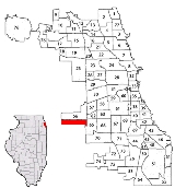
Clearing, one of the 77 official community areas
, is located on the southwest side of the City of Chicago, Illinois. The southern portion of Chicago Midway International Airport is located in this community area.
The Clearing Industrial District was founded in 1907. The area gets its name from the fact that farm goods from the area were "cleared" (delivered) through the airport and railroad yards. Clearing was first incorporated as a town in 1912. The Clearing area quickly became a part of Chicago
in 1915 because the growing population needed services provided by the city. It is bordered on the west by Harlem Avenue, on the east by railroad tracks just east of Cicero Ave., to the North by 59th street and to the south by 65th street. The southern portion of Midway airport is in Clearing.
A small strip of residential hugs the southerly border of Midway Airport, while remaining in the Chicago city limits. A modestly sized park, 6.2 acres (25,090.5 m²), Lawler Park, is located in Clearing. Created in 1947, Lawler Park is home to organized Little League softball, a brick recreation building, sandboxes, and other playground equipment. Hale Park and Nathan Hale Elementary School, at 61st and Melvina, are also located in Clearing. Hale Park is home to an outdoor swimming pool, field house, ball fields, and playground equipment.
This neighborhood, along with Garfield Ridge, is commonly known as "Midway." This is because Midway airport is located in both neighborhoods.
Community areas of Chicago
Community areas in Chicago refers to the work of the Social Science Research Committee at University of Chicago which has unofficially divided the City of Chicago into 77 community areas. These areas are well-defined and static...
, is located on the southwest side of the City of Chicago, Illinois. The southern portion of Chicago Midway International Airport is located in this community area.
History
The history of Clearing begins shrouded in mystery. An anomalous subdivision begins showing up in maps as early as 1870. Local author and historian Robert Hill calls this the "Lost Village". This subdivision appears between present day Nashville and Narragansett and between 59th and 63rd streets. Though when names appear they are different than they are currently. For example Narragansett is Major. Which then of course moved several blocks to the east eventually.The Clearing Industrial District was founded in 1907. The area gets its name from the fact that farm goods from the area were "cleared" (delivered) through the airport and railroad yards. Clearing was first incorporated as a town in 1912. The Clearing area quickly became a part of Chicago
Chicago
Chicago is the largest city in the US state of Illinois. With nearly 2.7 million residents, it is the most populous city in the Midwestern United States and the third most populous in the US, after New York City and Los Angeles...
in 1915 because the growing population needed services provided by the city. It is bordered on the west by Harlem Avenue, on the east by railroad tracks just east of Cicero Ave., to the North by 59th street and to the south by 65th street. The southern portion of Midway airport is in Clearing.
A small strip of residential hugs the southerly border of Midway Airport, while remaining in the Chicago city limits. A modestly sized park, 6.2 acres (25,090.5 m²), Lawler Park, is located in Clearing. Created in 1947, Lawler Park is home to organized Little League softball, a brick recreation building, sandboxes, and other playground equipment. Hale Park and Nathan Hale Elementary School, at 61st and Melvina, are also located in Clearing. Hale Park is home to an outdoor swimming pool, field house, ball fields, and playground equipment.
This neighborhood, along with Garfield Ridge, is commonly known as "Midway." This is because Midway airport is located in both neighborhoods.

