

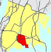
Clason Point, Bronx
Encyclopedia
Bronx Community Board 9
Bronx Community Board 9 is a local government unit of the city of New York, encompassing the neighborhoods of Castle Hill, Parkchester, Soundview, Bruckner, Harding Park, Bronx River, Clason Point and Unionport...
. Its boundaries, starting from the north and moving clockwise are: The Cross-Bronx Expressway
Cross-Bronx Expressway
The Cross Bronx Expressway is a major expressway in the New York City borough of the Bronx, conceived by Robert Moses and built between 1948 and 1972. It carries traffic on Interstate 95 through the city, and serves as a portion of Interstate 295 toward Long Island; a portion is also designated U.S...
to the north, White Plains Road
White Plains Road
White Plains Road is a major thoroughfare which runs the length of the Bronx, New York, from Castle Hill and Clason Point in the south to Wakefield in the north, where it crosses the city line and becomes West 1st Street of Mount Vernon, New York. The Bronx River Parkway lies to its west and...
to the east, the East River
East River
The East River is a tidal strait in New York City. It connects Upper New York Bay on its south end to Long Island Sound on its north end. It separates Long Island from the island of Manhattan and the Bronx on the North American mainland...
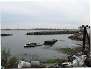
to the south, and the Bronx River
Bronx River
The Bronx River, approximately long, flows through southeast New York in the United States. It is named after colonial settler Jonas Bronck. The Bronx River is the only fresh water river in New York City....
to the west. Soundview Avenue is the primary thoroughfare through Clason Point. The local subway is the 6
6 (New York City Subway service)
The 6 Lexington Avenue and Pelham Local and Lexington Avenue Local and Pelham Express are two rapid transit services of the New York City Subway. The 6 local has a circle shape while the ' express has a diamond shape...
line; operating along Westchester Avenue. ZIP codes include 10472 and 10473. The area is patrolled by the 43rd Precinct located at 900 Fteley Avenue. NYCHA property in the area is patrolled by PSA 8 at 2794 Randall Avenue in the Throggs Neck section of the Bronx.
History
In ancient times, the Bronx River area to the West was known to the SiwanoySiwanoy
The Native American Siwanoy or Sinanoy were a band of Algonquian-speaking people, the Wappinger, in what is now the New York City area. By the mid-17th century, when their territory became hotly contested between Dutch and English colonial interests, the Siwanoy were settled along the East River...
s as "Aquahung". The site of a large Native American
Native Americans in the United States
Native Americans in the United States are the indigenous peoples in North America within the boundaries of the present-day continental United States, parts of Alaska, and the island state of Hawaii. They are composed of numerous, distinct tribes, states, and ethnic groups, many of which survive as...
settlement, comprising more than seventy dwellings, Clason Point was then known to natives as "Snakapins", or "Land By The Two Waters". There was a local and plentiful food source of oak acorn nuts for grinding purposes here.
In more modern times, an early English settler, Thomas Cornell, began farming here from 1654, for which the area became known as Cornell's Neck. Clason Point was named after Isaac Clason, a Scottish merchant and a major land owner. Development in the 19th century soon attracted resort seekers and the area became known for its amusements and entertainment. From 1883-1927, it was the site of the Clason Point Military Academy
La Salle Military Academy
La Salle Military Academy was a Catholic school with middle school/junior high school and high school divisions located in Oakdale, New York. It closed in 2001, and the school's extensive campus is now owned by St...
.
Clason Point in the early-20th century was an era of trolley cars on the main thoroughfare, Soundview Avenue or, as it was were, Clason Point Road. Clason Point was a mixture of mansions, farmland and plenty of undeveloped fields and swampland. There were ferryboat and steamer excursions from "The Point" to downtown (Manhattan
Manhattan
Manhattan is the oldest and the most densely populated of the five boroughs of New York City. Located primarily on the island of Manhattan at the mouth of the Hudson River, the boundaries of the borough are identical to those of New York County, an original county of the state of New York...
) as well as local service across the East River to College Point, Queens
College Point, Queens
College Point is a working-middle class neighborhood in the New York City borough of Queens. It is located north of Flushing on Flushing Bay and the East River and is part of the Queens Community Board 7. Willets Point Boulevard and the Whitestone Expressway are often the neighborhood's...
. The last boat to College Point terminated during World War II.
The area was then known for dance halls, roller coasters, picnic groves and baseball games, as well as the world's largest saltwater outdoor swimming pool known as "The Inkwell". There was a volunteer fire department, even a small airport and docks for sailboats and motorboats.
Clason Point was an area for family outings, children’s parades and, in contrast to the heavily built metropolis of today, open fields consisting of wild rabbit and pheasant.
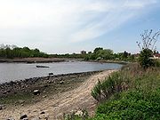
There were also many shoreline fishing spots where fish such as porgie, flounder, striped bass and bluefish could be caught. Alternatively, there were also plenty of saloons and novelty shops.
Kanes' was a major saloon in the Clason Point area in the 1920s which featured Helen Kane
Helen Kane
Helen Kane was an American popular singer; her signature song was "I Wanna Be Loved By You". Kane's voice and appearance were a likely source for Fleischer Studios animator Grim Natwick when creating Betty Boop, although It-girl Clara Bow is another possible influence.-Early life:Born as Helen...
, a singer who coined the phrase "Boop-oop-a-doop". Cartoon flapper Betty Boop
Betty Boop
Betty Boop is an animated cartoon character created by Max Fleischer, with help from animators including Grim Natwick. She originally appeared in the Talkartoon and Betty Boop film series, which were produced by Fleischer Studios and released by Paramount Pictures. She has also been featured in...
was modeled after her. After World War II, Kane's became the site for the Shorehaven Beach Club. The Shorehaven Beach Club was purchased by Soundview Associates an investment group including investors such as Sly Stallone & Zeckondorf and was to become the Shorehaven Condominiums. The Shorehaven Condominiums was planned to be composed of 1,183 condominium townhomes in a gated community. With all the amusement park rides and novelties in 'Clason Point Park' the Harding Park area of Clason Point was then known as "The Coney Island
Coney Island
Coney Island is a peninsula and beach on the Atlantic Ocean in southern Brooklyn, New York, United States. The site was formerly an outer barrier island, but became partially connected to the mainland by landfill....
of the Bronx".
Today the Harding Park section of Clason Point is known as "Little Puerto Rico
Puerto Rico
Puerto Rico , officially the Commonwealth of Puerto Rico , is an unincorporated territory of the United States, located in the northeastern Caribbean, east of the Dominican Republic and west of both the United States Virgin Islands and the British Virgin Islands.Puerto Rico comprises an...
" with narrow streets and bungalow type homes along the waterfront.
Subsections
Bronx RiverBronx River is a subsection of Clason Point. Its boundaries, starting from the north and moving clockwise are: The Cross-Bronx Expressway
Cross-Bronx Expressway
The Cross Bronx Expressway is a major expressway in the New York City borough of the Bronx, conceived by Robert Moses and built between 1948 and 1972. It carries traffic on Interstate 95 through the city, and serves as a portion of Interstate 295 toward Long Island; a portion is also designated U.S...
to the north, White Plains Road to the east, Westchester Avenue to the south, and the Bronx River to the west. Bronx River includes the Bronx River Houses. The area is usually included in the Soundview section.
Harding Park
Harding Park, Bronx
Harding Park is a working class residential neighborhood geographically located in the south central Bronx in New York City. The neighborhood is part of Bronx Community Board 9. Its boundaries, starting from the north and moving clockwise are: Lacombe Avenue to the north, Pugsley's Creek to the...
is a subsection of Clason Point. Its boundaries, starting from the north and moving clockwise are: Lacombe Avenue to the north, Pugsley's Creek to the east, the East River to the south, and the Bronx River to the west. Harding Park includes "Little Puerto Rico". The area is also referred to as Clason Point.
Soundview-Bruckner
Soundview-Bruckner is a subsection of Clason Point. Its boundaries, starting from the north and moving clockwise are: Westchester Avenue to the north, White Plains Road to the east, the Bruckner Expressway to the south, and the Bronx River to the west. Soundview-Bruckner includes the Bronxdale Houses. The area is usually included in the Soundview section.
Soundview
Soundview
Soundview, Bronx
Soundview is primarily a residential neighborhood geographically located in the South Central section of the Borough of The Bronx in New York City. The neighborhood is part of Bronx Community Board 9...
is a subsection of Clason Point. Its boundaries, starting from the north and moving clockwise are: the Bruckner Expressway to the north, White Plains Road to the east, Lacombe Avenue to the south, and the Bronx River to the west. Soundview includes Soundview Park as well as multiple low income public housing developments.
Transportation
- Bx27: to Simpson St stationSimpson Street (IRT White Plains Road Line)Simpson Street is a local station on the IRT White Plains Road Line of the New York City Subway. Located at the intersection of Simpson Street and Westchester Avenue in the Bronx, it is served by the 2 train at all times, and the 5 train at all times except late nights and rush hours in the peak...
(via Rosedale Av) - Bx39: to Wakefield - 241st Street station (via White Plains Rd)
Facts
- Soundview Avenue once stretched from White Plains Road and O'brien Avenue in Harding Park to Westchester and Morrison Avenues in Soundview-Bruckner before the construction of the Bronx River ParkwayBronx River ParkwayThe Bronx River Parkway is a long parkway in downstate New York. It is named for the nearby Bronx River, which it parallels. The southern terminus of the parkway is at Story Avenue near Bruckner Expressway in the Bronx neighborhood of Soundview...
. It was then known as Clason's Point Road. - P.S. 100 in Soundview was named after Isaac Clason.
- The Clason Point Gardens, located in Soundview, was the first NYCHA development in the Bronx.
- The Clason's Point Branch of The New York Public Library is located at 1215 Morrison Avenue, just north of Westchester Avenue in Bronx River.
- The Clason Point post office is located at 873 Soundview Avenue just south of Story Avenue in Soundview.
- The Bruckner ExpresswayBruckner ExpresswayThe Bruckner Expressway is a freeway in The Bronx. It carries Interstate 278 and Interstate 95 from the Robert F. Kennedy Bridge to the south end of the New England Thruway at the Pelham Parkway interchange....
which now bisects the area along the center was once known as Ludlow Avenue.