
City of South Barwon
Encyclopedia
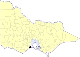
The City of South Barwon was a Local Government Area in Victoria
, Australia
, which contained some Geelong
suburbs south of the Barwon River
, and extending to Torquay
in the south and Barwon Heads
to the east. The city covered an area of 165.4 square kilometres (63.9 sq mi), and existed from 1863 until 1994.
on 2 June 1857. It then covered 9 square miles (23.3 km²) and 600 households. It was incorporated as a borough on 21 October 1863, and became a town on 24 December 1874 when it was almagmated with the Connewarre Road District, and now covered 64 square miles (165.8 km²) and 1714 people. It was proclaimed as a city on 6 December 1974.
The first council offices were in Mount Pleasant Road in Belmont, opened in 1884 at a cost of 1400 pounds. New chambers were built in 1970, and in 1974 plans were made for a new Civic Centre on the corner of the Princes Highway and Reynolds Road in Belmont. Plans were approved in 1976, a tender was accepted and the first sod turned in August 1977, and on May 24 1978 it was officially opened. The Mount Pleasant Road offices became a community centre. After amalgamation the Civic Centre was used by the City of Greater Geelong as offices, before being sold to Barwon Health.
On 18 May 1993, the City was abolished, and merged into the City of Greater Geelong
, despite concerns expressed by the coastal town of Torquay
that it was a separate community of interest from Geelong. The Shire of Barrabool
, which had been significantly reduced by the creation of the City and had lost much of its rates base, joined Torquay residents in suggesting the Kennett
Liberal
government create a coastal shire which united Torquay and Anglesea
. On 9 March 1994, the southern part of the City south of Mount Duneed Road merged with the remainder of the Shire of Barrabool
and Shire of Winchelsea
to create the Surf Coast Shire
, which established its administrative centre at Torquay.
 The City of South Barwon was divided into four wards on 19 May 1978, each of which elected three councillors:
* Estimate in the 1958 Victorian Year Book.
Victoria (Australia)
Victoria is the second most populous state in Australia. Geographically the smallest mainland state, Victoria is bordered by New South Wales, South Australia, and Tasmania on Boundary Islet to the north, west and south respectively....
, Australia
Australia
Australia , officially the Commonwealth of Australia, is a country in the Southern Hemisphere comprising the mainland of the Australian continent, the island of Tasmania, and numerous smaller islands in the Indian and Pacific Oceans. It is the world's sixth-largest country by total area...
, which contained some Geelong
Geelong, Victoria
Geelong is a port city located on Corio Bay and the Barwon River, in the state of Victoria, Australia, south-west of the state capital; Melbourne. It is the second most populated city in Victoria and the fifth most populated non-capital city in Australia...
suburbs south of the Barwon River
Barwon River (Victoria)
The Barwon River rises in the Otway Ranges of Victoria, Australia, runs through Winchelsea and the city of Geelong, where it is joined by the Moorabool River, and enters the sea at Barwon Heads after passing through Lake Connewarre on the Bellarine Peninsula...
, and extending to Torquay
Torquay, Victoria
Torquay is a township in Victoria, Australia, which faces Bass Strait, 21 km. south of Geelong and is the gateway to the Great Ocean Road. It is bordered on the west by Spring Creek and its coastal features include Point Danger and Zeally Bay...
in the south and Barwon Heads
Barwon Heads, Victoria
Barwon Heads is a coastal township on the Bellarine Peninsula, near Geelong, Victoria, Australia. It is situated on the west bank of the mouth of the Barwon River below Lake Connewarre, while it is bounded to the west by farmland, golf courses and the ephemeral saline wetland Murtnaghurt...
to the east. The city covered an area of 165.4 square kilometres (63.9 sq mi), and existed from 1863 until 1994.
History
South Barwon was formed as a Roads District when it was severed from the Corporation of GeelongCity of Geelong
The City of Geelong was a Local Government Area located about southwest of Melbourne, the state capital of Victoria, Australia. The city covered an area of , and existed from 1849 until 1994.-History:...
on 2 June 1857. It then covered 9 square miles (23.3 km²) and 600 households. It was incorporated as a borough on 21 October 1863, and became a town on 24 December 1874 when it was almagmated with the Connewarre Road District, and now covered 64 square miles (165.8 km²) and 1714 people. It was proclaimed as a city on 6 December 1974.
The first council offices were in Mount Pleasant Road in Belmont, opened in 1884 at a cost of 1400 pounds. New chambers were built in 1970, and in 1974 plans were made for a new Civic Centre on the corner of the Princes Highway and Reynolds Road in Belmont. Plans were approved in 1976, a tender was accepted and the first sod turned in August 1977, and on May 24 1978 it was officially opened. The Mount Pleasant Road offices became a community centre. After amalgamation the Civic Centre was used by the City of Greater Geelong as offices, before being sold to Barwon Health.
On 18 May 1993, the City was abolished, and merged into the City of Greater Geelong
City of Greater Geelong
The City of Greater Geelong is a Local Government Area in Victoria, Australia.It is located in the western part of the state, south-west of Melbourne. It has an area of 1,240 square kilometres. In 2006 it had a population of 191,000...
, despite concerns expressed by the coastal town of Torquay
Torquay, Victoria
Torquay is a township in Victoria, Australia, which faces Bass Strait, 21 km. south of Geelong and is the gateway to the Great Ocean Road. It is bordered on the west by Spring Creek and its coastal features include Point Danger and Zeally Bay...
that it was a separate community of interest from Geelong. The Shire of Barrabool
Shire of Barrabool
The Shire of Barrabool was a Local Government Area located about southwest of Melbourne, the state capital of Victoria, Australia. The shire covered an area of , and existed from 1853 until 1994.-History:...
, which had been significantly reduced by the creation of the City and had lost much of its rates base, joined Torquay residents in suggesting the Kennett
Jeff Kennett
Jeffrey Gibb Kennett AC , a former Australian politician, was the Premier of Victoria between 1992 and 1999. He is currently the President of Hawthorn Football Club. He is the founding Chairman of beyondblue, a national depression initiative.- Early life :Kennett was born in Melbourne on 2 March...
Liberal
Liberal Party of Australia
The Liberal Party of Australia is an Australian political party.Founded a year after the 1943 federal election to replace the United Australia Party, the centre-right Liberal Party typically competes with the centre-left Australian Labor Party for political office...
government create a coastal shire which united Torquay and Anglesea
Anglesea, Victoria
Anglesea is a town in Victoria, Australia. It is located on the Great Ocean Road in the Surf Coast Shire local government area. At the 2006 census, Anglesea had a population of 2,290....
. On 9 March 1994, the southern part of the City south of Mount Duneed Road merged with the remainder of the Shire of Barrabool
Shire of Barrabool
The Shire of Barrabool was a Local Government Area located about southwest of Melbourne, the state capital of Victoria, Australia. The shire covered an area of , and existed from 1853 until 1994.-History:...
and Shire of Winchelsea
Shire of Winchelsea
The Shire of Winchelsea was a Local Government Area located about southwest of Melbourne, the state capital of Victoria, Australia. The shire covered an area of , and existed from 1860 until 1994.-History:...
to create the Surf Coast Shire
Surf Coast Shire
Surf Coast Shire is a Local Government Area in Victoria, Australia. It is located in the southern part of the state, near Geelong. It includes the towns of Aireys Inlet, Anglesea, Lorne, Moriac, Torquay and Winchelsea. It has an area of 1,553 square kilometres. It had a population of 24,124 in 2006...
, which established its administrative centre at Torquay.
Wards
- Belmont Ward
- Connewarre Ward
- Grovedale Ward
- Highton Ward
Towns and Localities
- Barwon HeadsBarwon Heads, VictoriaBarwon Heads is a coastal township on the Bellarine Peninsula, near Geelong, Victoria, Australia. It is situated on the west bank of the mouth of the Barwon River below Lake Connewarre, while it is bounded to the west by farmland, golf courses and the ephemeral saline wetland Murtnaghurt...
- BelmontBelmont, VictoriaBelmont is a southern suburb of Geelong, Victoria, Australia. The name means "beautiful hill". Belmont is geographically separated from the Geelong central business district by the Barwon River. The suburb is primarily residential, with some light industry along Barwon Heads Road...
- BreamleaBreamlea, VictoriaBreamlea, Victoria, Australia, is a secluded seaside hamlet located 28 km south of Geelong on the south coast of Australia halfway between Barwon Heads and Torquay on the Bellarine Peninsula. At the 2006 census, Breamlea and the surrounding area had a population of 244.-Geography:Breamlea is...
- ConnewarreConnewarre, VictoriaConnewarre, Victoria, Australia, is located in southern Australia in an area that is sparsely populated. At the 2006 census, Connewarre and the surrounding area had a population of 78....
- GrovedaleGrovedale, VictoriaGrovedale is a mainly residential southern suburb of Geelong, Victoria, Australia.The suburb is bounded by the Waurn Ponds Creek, Rossack Drive, Boundary Road and Barwarre Road.-Toponomy:...
- HightonHighton, VictoriaHighton is a residential suburb of Geelong, Victoria, Australia. It is bordered by the Barrabool Hills and Wandana Heights to the west, the Barwon River to the north and east, the former Kardinia Creek to the south-east, and the Princes Highway and Pigdons Road to the south.-History:Grazier John...
- MarshallMarshall, VictoriaMarshall, formerly known as Marshalltown, is a residential suburb of Geelong, Victoria, Australia.The section of the locality south of the Marshall Railway Station is part of the large Armstrong Creek Growth Area with development beginning in 2010....
- Mount DuneedMount Duneed, VictoriaMount Duneed is a suburb of Geelong, Victoria, Australia. The Geelong Airport is located in Mount Duneed. Though the airport continues to operate, the site is for sale as of July 2005 , and it appears likely that it will be demolished to make way for housing....
(split with BarraboolShire of BarraboolThe Shire of Barrabool was a Local Government Area located about southwest of Melbourne, the state capital of Victoria, Australia. The shire covered an area of , and existed from 1853 until 1994.-History:...
) - TorquayTorquay, VictoriaTorquay is a township in Victoria, Australia, which faces Bass Strait, 21 km. south of Geelong and is the gateway to the Great Ocean Road. It is bordered on the west by Spring Creek and its coastal features include Point Danger and Zeally Bay...
(split with BarraboolShire of BarraboolThe Shire of Barrabool was a Local Government Area located about southwest of Melbourne, the state capital of Victoria, Australia. The shire covered an area of , and existed from 1853 until 1994.-History:...
)
Population
| Year | Population |
|---|---|
| 1954 | 11,016 |
| 1958 | 14,520* |
| 1961 | 16,794 |
| 1966 | 22,049 |
| 1971 | 26,764 |
| 1976 | 32,411 |
| 1981 | 35,307 |
| 1986 | 38,019 |
| 1991 | 40,772 |
* Estimate in the 1958 Victorian Year Book.