
City of Joondalup
Encyclopedia
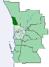
The City of Joondalup is a council and Local Government Area
with City status in Perth, Western Australia
. It covers the metropolitan Perth city of Joondalup in its entirety, as well as the town centres of Hillarys
and Warwick
.
The City covers an area of 98.9 square kilometres (38.2 sq mi) from Kinross in the north, to Warwick in the south, with a population of about 150,000 at the 2006 census. At the 2001 census, 18% of the population were born in the United Kingdom, while the area was also home to significant Italian, Polish, Chinese and Malaysian minorities.
to the south, Wanneroo Road
and Lake Joondalup
to the east, Tamala Park
to the north and the Indian Ocean
to the west.
and the construction of the Joondalup railway line.
Until 1998, the area had been controlled by the City of Wanneroo and its predecessors. An independent commission suggested the creation of Joondalup out of the coastal areas of Wanneroo, and the City of Joondalup came into existence on 1 July 1998.
), Peter Clough, Michael Anderson, Anne Fox and Steve Smith. The Council's power was temporarily transferred to the Commissioners, for a period envisioned to last until the Local Government elections in May 2005 (as it turned out, the next elections were in fact held in May 2006, under Section 4.14 of the Local Government Act 1995 http://www.waec.wa.gov.au/local/wards.asp?agencyid=48&electdate=6-May-2006&electionid=230).
A subsequent inquiry, referred to as the McIntyre Inquiry after its Chairman Greg McIntyre, revealed in October 2005 that the Council had effectively split into two opposing groups over a controversy surrounding the qualifications of the city's Chief Executive Officer (CEO). The CEO in question, Denis Smith, was accused of misrepresenting his educational qualifications by Deputy Mayor Don Carlos. Don Carlos demanded Denis Smith's immediate dismissal, but his motion was unsuccessful. The Councillors opposed to Denis Smith's dismissal expressed the view that the CEO should not be dismissed as his performance was satisfactory. Instead, the council passed a motion forbidding Don Carlos from publicly criticizing Denis Smith.
Don Carlos subsequently became Mayor of Joondalup at the next election.
* Part of Woodvale is located within the City of Wanneroo.
Local Government Areas of Western Australia
The Australian state of Western Australia is divided into 141 local government areas...
with City status in Perth, Western Australia
Perth, Western Australia
Perth is the capital and largest city of the Australian state of Western Australia and the fourth most populous city in Australia. The Perth metropolitan area has an estimated population of almost 1,700,000....
. It covers the metropolitan Perth city of Joondalup in its entirety, as well as the town centres of Hillarys
Hillarys, Western Australia
Hillarys is a northern coastal suburb of Perth, the capital city of Western Australia. Its Local Government Area is the City of Joondalup. It is part of the Whitfords precinct, and is located 21 km north-northwest of Perth's central business district via Mitchell Freeway and Hepburn...
and Warwick
Warwick, Western Australia
Warwick is a suburb of Perth, Western Australia, located within the City of Joondalup. Its postcode is 6024. The eastern third of the suburb is a native bushland area known as the Warwick Open Space....
.
The City covers an area of 98.9 square kilometres (38.2 sq mi) from Kinross in the north, to Warwick in the south, with a population of about 150,000 at the 2006 census. At the 2001 census, 18% of the population were born in the United Kingdom, while the area was also home to significant Italian, Polish, Chinese and Malaysian minorities.
Geography
The City is bounded by Beach RoadBeach Road, Perth
Beach Road is a major east-west road in the northern suburbs of Perth, Western Australia, connecting Perth's inner northern beachside suburbs and inland state housing areas with shopping and public transport facilities at Warwick and the Malaga industrial area...
to the south, Wanneroo Road
Wanneroo Road
Wanneroo Road is an important arterial road in Perth, Australia. It is about 75 kilometres long. It links Perth with the City of Wanneroo, and the Towns of Yanchep and Lancelin...
and Lake Joondalup
Lake Joondalup
Lake Joondalup is a medium sized lake in Perth, Western Australia. It is located in the Perth northern suburbs of Joondalup, Wanneroo, and Edgewater. It is a nature reserve and part of the Yellagonga Regional Park.-Features:...
to the east, Tamala Park
Tamala Park, Western Australia
Tamala Park is an unpopulated locality in Perth, Western Australia. It sits on the border between the City of Wanneroo and the City of Joondalup local authorities, and separates the Clarkson-Butler region from the suburbs of Joondalup.-History:...
to the north and the Indian Ocean
Indian Ocean
The Indian Ocean is the third largest of the world's oceanic divisions, covering approximately 20% of the water on the Earth's surface. It is bounded on the north by the Indian Subcontinent and Arabian Peninsula ; on the west by eastern Africa; on the east by Indochina, the Sunda Islands, and...
to the west.
History
Prior to the 1970s, the region now known as the City of Joondalup was sparsely populated. During the 1980s and 1990s, massive growth occurred, partly due to State Government policies which made Joondalup a regional centre, including the extension of the Mitchell FreewayMitchell Freeway
Mitchell Freeway is a long freeway in Perth, Western Australia, linking Perth's central business district with its outer northern suburbs. It is allocated Route 2 for its entire length and is named after former state Premier and Governor Sir James Mitchell....
and the construction of the Joondalup railway line.
Until 1998, the area had been controlled by the City of Wanneroo and its predecessors. An independent commission suggested the creation of Joondalup out of the coastal areas of Wanneroo, and the City of Joondalup came into existence on 1 July 1998.
Mayors
- 1998-2003 John Bombak
- 2003 Don Carlos
- 2003-2006 (suspended)
- 2006–present Troy Pickard
2003-2004 Council controversy
Joondalup City's elected Council (including the Mayor) was suspended by Tom Stephens, the Minister for Local Government, on 5 December 2003 after receiving complaints indicating that the Council had become dysfunctional. The Council was replaced by five Commissioners; Chairman John Paterson (former Mayor of NedlandsNedlands, Western Australia
The City of Nedlands is a Local Government Area in the inner western suburbs of the Western Australian capital city of Perth, located about west of Perth's central business district...
), Peter Clough, Michael Anderson, Anne Fox and Steve Smith. The Council's power was temporarily transferred to the Commissioners, for a period envisioned to last until the Local Government elections in May 2005 (as it turned out, the next elections were in fact held in May 2006, under Section 4.14 of the Local Government Act 1995 http://www.waec.wa.gov.au/local/wards.asp?agencyid=48&electdate=6-May-2006&electionid=230).
A subsequent inquiry, referred to as the McIntyre Inquiry after its Chairman Greg McIntyre, revealed in October 2005 that the Council had effectively split into two opposing groups over a controversy surrounding the qualifications of the city's Chief Executive Officer (CEO). The CEO in question, Denis Smith, was accused of misrepresenting his educational qualifications by Deputy Mayor Don Carlos. Don Carlos demanded Denis Smith's immediate dismissal, but his motion was unsuccessful. The Councillors opposed to Denis Smith's dismissal expressed the view that the CEO should not be dismissed as his performance was satisfactory. Instead, the council passed a motion forbidding Don Carlos from publicly criticizing Denis Smith.
Don Carlos subsequently became Mayor of Joondalup at the next election.
Wards & Suburbs
The suburbs of the City of Joondalup are grouped into six wards, each represented by two Councillors:| Ward | Suburbs, villages and districts |
|---|---|
| North Ward | Burns Beach Burns Beach, Western Australia Burns Beach is a suburb of Perth, Western Australia, located north of Perth's central business district at the northern fringe of the City of Joondalup... , Connolly Connolly, Western Australia Connolly is a northern suburb of Perth, Western Australia, located within the City of Joondalup adjacent to Joondalup's central business district. It was built in the late 1980s as a golf course estate. Its eastern border backs onto the Mitchell Freeway road reserve... , Currambine Currambine, Western Australia Currambine is a northern suburb of Perth, the capital city of Western Australia, and is located 30 km north of Perth's central business district. Its Local Government Area is the City of Joondalup. It contains the Currambine Market Place shopping centre and cinema complex.-History:Currambine... , Iluka Iluka, Western Australia Iluka is a far northern, fast-developing beachside suburb of Perth, Western Australia, located within the City of Joondalup. The popular surfing spots in the region include Mullaloo Beach, Sorrento Beach and Hillarys Beach... , Joondalup City Centre Joondalup (suburb) Joondalup is a suburb of Perth, Western Australia, which includes the central business district of the regional city of Joondalup, as well as the council chambers for the City of Joondalup local authority.-History:... , Kinross Kinross, Western Australia Kinross is a small suburb in the City of Joondalup located in the northern suburbs of Perth, Australia. Kinross was constructed around 1992-3 in various stages. It is bordered by Neerabup National Park, and is the City of Joondalup's most northerly suburb.... |
| North Central Ward | Edgewater Edgewater, Western Australia Edgewater is a suburb of Perth, Western Australia, located north of Perth's central business district. Edgewater was approved as a suburb name in 1974, and its local government area is the City of Joondalup... , Heathridge, Mullaloo Mullaloo, Western Australia Mullaloo is a northern coastal suburb of Perth, Western Australia, located within the City of Joondalup.-History:Mullaloo is named after an Aboriginal word, believed to mean "place of the rat kangaroo". It was first recorded in 1919 as Moolalloo Point, but the spelling was later changed to Mullaloo... , Ocean Reef Ocean Reef, Western Australia Ocean Reef is a suburb in northern Perth, Western Australia. It is located within the City of Joondalup. The name was coined by developers in the 1970s from the line of a reef visible several kilometres offshore... |
| Central Ward | Beldon Beldon, Western Australia Beldon is a small suburb of Perth, Western Australia, located within the City of Joondalup, to the north of Craigie. Beldon contains two schools — Beldon Primary School and Belridge Senior High School.... , Craigie Craigie, Western Australia Craigie is located in the northern suburbs of the Perth metropolitan area. Craigie was chosen as a suburb name in 1970 and honours an early councillor of the City of Wanneroo who did much work in developing the City... , Kallaroo Kallaroo, Western Australia Kallaroo is one of the four 'Whitfords' suburbs that resulted from the StateGovernment rezoning large areas of coastal land for development in 1969. Kallaroo was chosen as a suburb name in 1970 and is an Aboriginal word meaning ‘road to the water’. The suburb is home to one primary school,... , Woodvale Woodvale, Western Australia Woodvale is a suburb of Perth, Western Australia, located within the City of Joondalup and the City of Wanneroo. Its postcode is 6026.Woodvale is bounded to the south by Whitfords Avenue, to the west by the Mitchell Freeway, to the north by Ocean Reef Road and to the east by Wanneroo Road... * |
| South West Ward | Hillarys Hillarys, Western Australia Hillarys is a northern coastal suburb of Perth, the capital city of Western Australia. Its Local Government Area is the City of Joondalup. It is part of the Whitfords precinct, and is located 21 km north-northwest of Perth's central business district via Mitchell Freeway and Hepburn... , Padbury Padbury, Western Australia Padbury is a suburb of Perth, Western Australia, located within the City of Joondalup. Its postcode is 6025. The suburb was named in 1971 after the notable Western Australian settler Walter Padbury... , Sorrento Sorrento, Western Australia Sorrento is a northern coastal suburb of Perth, the capital city of Western Australia. Its Local Government Area is the City of Joondalup. At its northwestern corner is the Hillarys Boat Harbour, built in the late 1980s.-History:... |
| South Ward | Duncraig Duncraig, Western Australia Duncraig is a large northern suburb of Perth, the capital city of Western Australia, Australia, and is located north of Perth's central business district between Marmion Avenue and Mitchell Freeway... , Marmion Marmion, Western Australia Marmion is a northern coastal suburb of Perth, the capital city of Western Australia. Its Local Government Area is the City of Joondalup.-History:... , Warwick Warwick, Western Australia Warwick is a suburb of Perth, Western Australia, located within the City of Joondalup. Its postcode is 6024. The eastern third of the suburb is a native bushland area known as the Warwick Open Space.... |
| South East Ward | Greenwood Greenwood, Western Australia Greenwood, is a suburb of Perth, Western Australia, located in the City of Joondalup. The suburb is located 18 km from Perth's central business district.-History:... , Kingsley Kingsley, Western Australia Kingsley is a suburb of Perth, Western Australia, located within the City of Joondalup. Kingsley is bounded to the north by Whitfords Avenue, to the south by Hepburn Avenue, to the west by the Mitchell Freeway and to the east by Wanneroo Road.... |
* Part of Woodvale is located within the City of Wanneroo.
Population
| Year | Population |
|---|---|
| 1991 | 122,152 |
| 1996 | 140,193 |
| 2001 | 147,126 |
| 2006 | 149,673 |